Maps are the basic building blocks for my railfan guides.
They offer the railfan a perspective which is lacking in other forms of railfan
guides, not to say that there aren't some good non-map oriented guides out
there. But a map which is annotated with the things that interest railfans
helps you plan your trip. You can see for yourself if a particular item is
something you want to spend your time chasing after. Some railfans may
like the old buildings, some not. Some guys like to visit the yards,
others do not. Some just want to know where the busiest place is so they
can maximize their photo time. So I present to ya'll everything I know of
that might interest any and all of you. I also know that a lot of railfans
are into the fire and police scene, so I try to include those points of interest
on my maps (and any other "neat" things).
Since starting the Baltimore Guide, I have expanded the
scope and selection by covering DC, and also have a Central
Maryland section.
Please note: This and all of my pages
are done with Frontpage, a Microsoft product. If you use a non-uS browser
such as Mozilla or Firefox, I can not guarantee that you will see the pages the
way I designed them.....
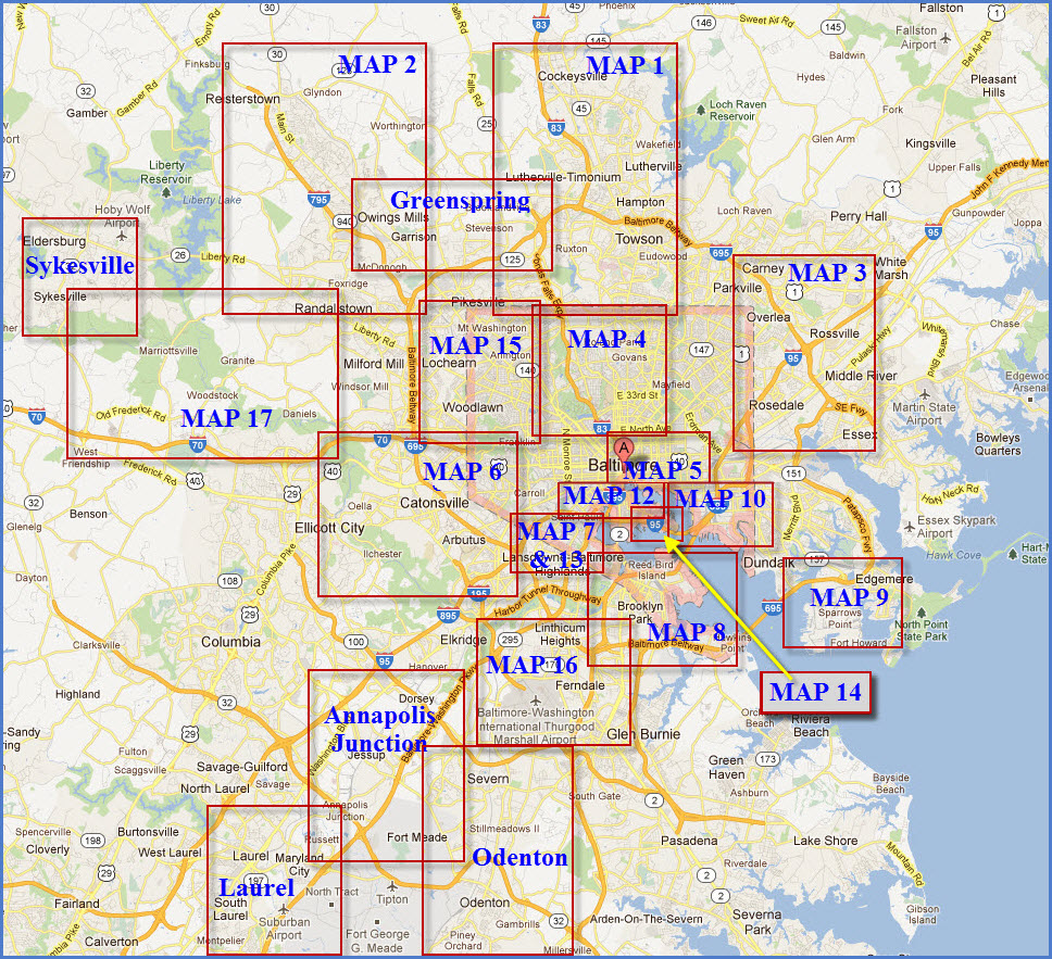
MAP 1 ............ Northern Suburbs of Baltimore -- Towson, utherville, Timonium, and the Cockeysville areas MAP 2 ............ NW Suburbs of Baltimore -- Glyndon, Reisterstown, Owings Mills, Pikesville, the Metro, and the old WM MAP 3 ............ NE Suburbs of Baltimore -- Rt 40/Pulaski Highway, Middle River, Golden Ring, and Whitemarsh MAP 4 ............ Northern Baltimore City -- from North Ave and north MAP 5N ......... Central Baltimore City -- from North Ave down to Baltimore St MAP 5S ......... Central Baltimore City MAP 6 ............ West Suburbs of Baltimore -- Catonsville, Ellicott City, Elkridge, and Thomas Viaduct MAP 7 ............ Southwest Baltimore -- Carroll Viaduct, Mt Winan's Yard, and a full CPL MAP 8 ............ South Baltimore -- mostly the CSX yards MAP 9 ............ SE Suburbs of Baltimore -- mostly the Sparrows Point area MAP 10 .......... East Baltimore 1 -- Highlandtown, Canton, and the docks MAP 11 .......... East Baltimore 2 -- the CSX & NS Bayview Yards area MAP 12 .......... South Downtown Baltimore -- CSX's Bailey Wye area and the B&O Transportation Museum MAP 13 .......... CSX Mt Winans Yard and Zepp's Bridge (detail map for MAP 7) MAP 14 .......... SE Downtown Baltimore -- Riverside and Locust Point (workin on it) MAP 15 .......... NW Baltimore - Following the WM and Metro out of town MAP 16 .......... SW Suburbs of Baltimore -- the Glen Burnie, Ferndale and BWI areas MAP 17 .......... West of Baltimore -- Following the Old Main Line - Ellicott City to Sykesville
Also, starting in 2016, I broke out individual areas of each map into their own page, for instance, MAP 1 covers Towson, Ruxton, Riderwood, Lutherville, Timonium, Texas, Cockeysville, Hunt Valley, and Monkton.
Most of these have their own pages now.
In case you're wondering how I came to number the maps... there's no system to it, it was pretty much when I did the maps, starting with the Towson to Cockeysville area I live in. I generally
went from north to south, wound up numbering one of them 16 for some unknown reason, then a few years later, came back and added maps 14 and 15, realizing that the areas covered by them
wasn't covered by any of the other maps.
RAILFAN MAPS of MARYLAND and the CENTRAL MARYLAND RAILFAN GUIDE
In an effort to keep overhead simple for me, I have decided to direct you to the appropriate pages for specific sections instead of trying to keep 3 or 4 pages updated with the same info....
So please see my master map guide for Maryland at: https://railfanguides.us/#MARYLAND