Getting around and knowing where to go is the worst part of being in a strange
town, trust me, I have been there many, many times in places like Minneapolis,
Portland OR, Boston, Kansas City, St Louis, Los Angeles, and especially Chicago.
I usually keep notes and hand drawn maps of most of the places I visit, but it takes
an immense amount of time to transcribe those hand drawn notes into something really
useful, like what you see here and in the rest of my guides at
www.railfanguides.us.
With that said, almost every one of my guides has a map created by myself to
augment what you can see on your GPS or cellphone maps. Most DO NOT show
anything railroad oriented, unless they are major in nature, like Penn Station
or Grand Central Terminal.
Location / Name:
The Baltimore area consists of:
-- Baltimore City (self contained, does not reside in any county like Atlanta does (It's in five different counties!)
-- Baltimore County (to the west, north, and east)
-- Anne Arundel County (to the southwest)
What's Here:
Stations: Penn Station, Camden, Mt Royal, Riderwood, Monkton, Maple Rd, Greensping, Lake Ave
Yards: Riverside, Grays, Locust Point,
Railroads: CSX, NS, Amtrak, Canton, MARC, Baltimore Industrial Railroad
Access by train/transit:
Amtrak
MARC - Maryland Rail Commuter
Geography:
flat to very hilly in places, especially the further away from the harbor you get, especially going north
The Scoop:
I've lived in Baltimore since 1966. Because of that, the guides to
stuff in and around Baltimore will be the largest collection of guides for any
one area, with Philadelphia coming in second.
This guide, as all of mine are, is map oriented. There are a several other web sites and guides around
for Baltimore, but most don't go into much detail except for several excellent
CSX Tours. You'll find
other links in the link section. If you prefer text versions of guides, they exist too, but they
aren't much help if you get lost.
Acknowledgements:
Denver Todd
Google Maps
Bing Maps
Open Railway Map
Wikipedia
So... When you think of Baltimore and trains, what railroads come to mind?
Baltimore was the home to quite a few railroads:
The first railroad in the United States, the Baltimore
and Ohio RR
The Western Maryland Rwy, which later became part of
the Chessie System and then CSX
The Maryland & Pennsylvania RR,
affectionately known as the Ma & Pa
The Canton RR
The Patapsco & Back River RR,
once part of the huge Bethlehem Steel continuum
The Baltimore & Susquehanna RR,
Baltimore's second railroad which later became the Northern Central, and then part of the Pennsy
The Baltimore & Annapolis RR
The only railroad that serviced Baltimore, and did not call it home, was the
Pennsylvania RR.
Up till 1963, Baltimore had seven railroads for the railfan to enjoy, now there
are five, plus the two transit lines (do they really count?):
CSX
Norfolk Southern
Amtrak
The Canton RR
MARC
The Light Rail system
The Metro Subway
With the former Beth Steel plant now shut down, the P&BRRR hasn't been running for some time.
Today, the B&O is CSX, (via the Chessie
System). The passenger
portion of the Pennsy is the Amtrak Northeast Corridor
(NEC)(via the Penn Central), and the freight portion became
Norfolk Southern (via the Penn Central and
Conrail). We did lose long distance freights on the Northern Central
branch back in PC era of 1972 with the advent of Hurricane Agnes, and then the
local in 2005 when the MTA double-tracked the line.
The state run Canton Railroad still services
a few local industries and offers a break from the big Class one's....
Last but not least, over on the southeast side of town at the (former) Beth Steel plant
is the Patapsco and River RR.
With no activity at "the Point", the railroad is no longer in operation.
Another railroad that we lost back
in the 1990's, is the Baltimore & Annapolis RR,
which was taken over by the MTA when they headed south to Cromwell.
Baltimore has been fortunate in this day and age of consolidations and "trimming
the fat" that it has not lost much in the way of trackage.
One exception is the former Western Maryland's Port
Covington yard. Other than that, Baltimore pretty much still has all the
track it had 40 years ago.
Although not heavily emphasized by
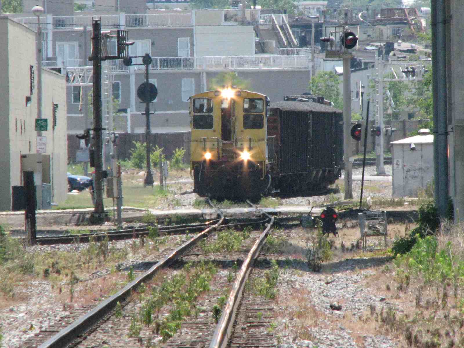
railfans, there is plenty of railroad action in
Baltimore. There is plenty of CSX action available all day long, and Norfolk
Southern can be found most of the time, but generally not on the Corridor until
after 10pm (except for a few locals). There are plenty of stations, structures,
and what-nots to take in, if you're into that kind of thing.
A note which I feel rather strongly about... if
you are a railfan, go out and take pictures of everything.
The reason I say this is because as a youngster in my late teens and 20's (in
the late 60's and into the 70's), I didn't get out as much as I should have.
One reason was being poor while you're of college age, and back then, you didn't
have the digital format, where you could take thousands of pictures for next to
nothing. Print pictures were pretty crappy, and slides weren't all that
cheap. So it was tough trying to go to school, have a part time job paying
a buck seventy-five an hour, and then paying three bucks for a roll of
slide film and another 2 or 3 to get it developed.... ouch! Also, I went
up to Connecticut back in 1994 with several other railfans, and one of them
didn't particularly care to take pictures of the CT Centrals old dilapidated
engines with multiple paint schemes showing through. Too bad, for the
railroad disappeared, and he has precious few pix of the stuff we saw!
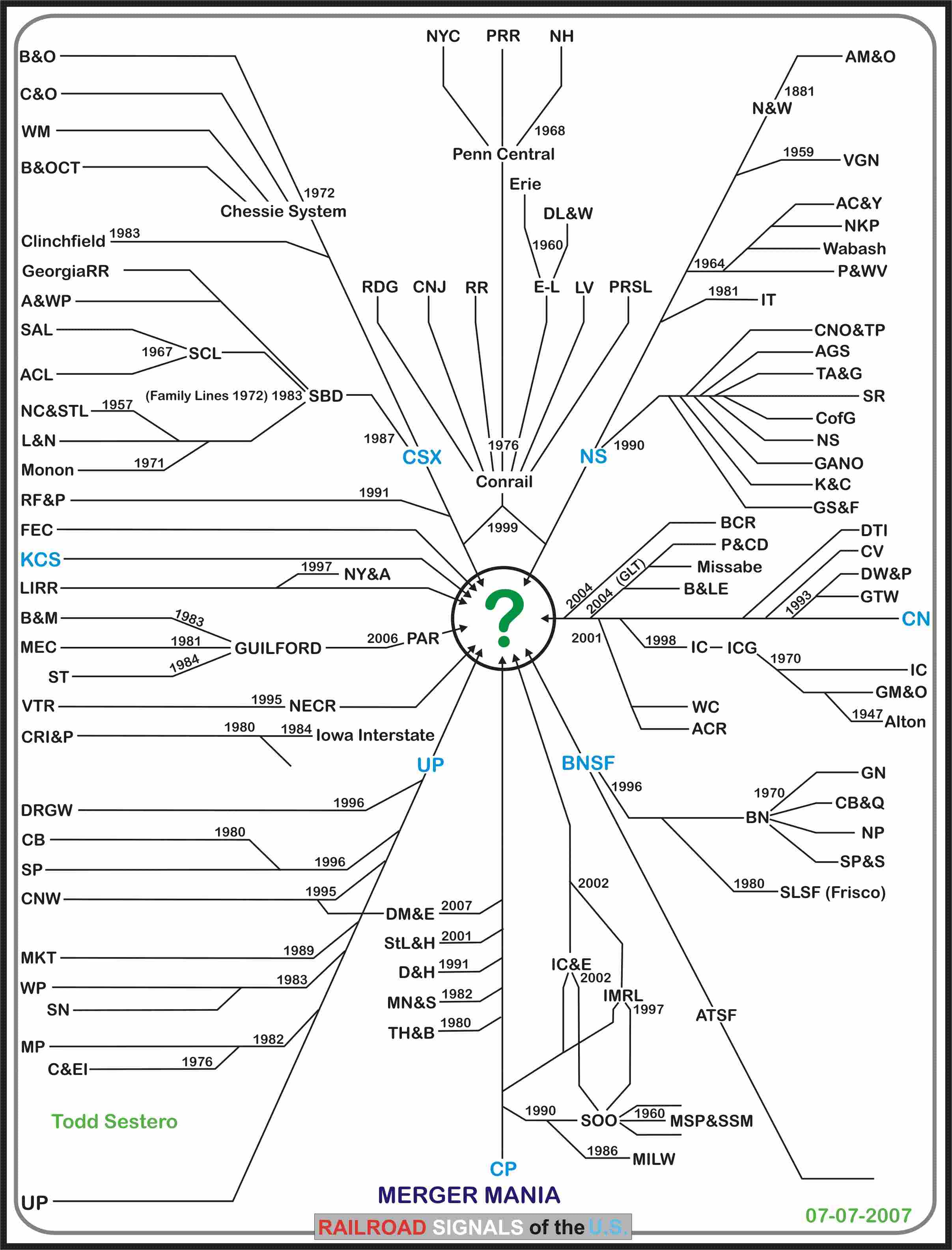
Another reason..... look at the
merger chart below. Around the edges, most (but not all) of those
railroads were around when I started taking pictures (1964). They were the
major roads of the 50's and 60's. Now all we have is pretty much the
railroads in blue. There are some "larger" shortlines, and many short
shortlines, but overall, the action just isn't like it used to be.... go out and
take those pictures!
Getting around and knowing where to go is the worst part of being in a
strange town, trust me, I have been there many, many times in places like
Minneapolis, Portland OR, Boston, Kansas City, St Louis, Los Angeles, and
especially Chicago. I usually keep notes and hand drawn maps of most of
the places I visit, but it takes an immense amount of time to transcribe those
hand drawn notes into something really useful, like what you see here and in the
rest of my guides at www.railfanguides.us.
For the signal fan, Baltimore has a shrinking variety of railroad signals, mainly:
CPL's (Color Position Light/B&O),
PL's (Position Light/PRR),
Amtrak PCL signals (colorized versions of the Pennsy PL signals,
and color light signals.
The Western Maryland used colorlight
signals, but since it was absorbed by CSX, very, very few of them remain.
As of late 2015,
CSX's signal replacement program is pretty much complete in the Baltimore area,
and only CPL's remaining that I know of, is a fixed RESTRICT signal adjacent to
the Light Rail Westport station, and signals protecting the swing bridge in
Sparrows Point.
As far as PL signals go around here, almost all
of the high signals are now Amtrak PCL signals, except for a few high pedestals
at Penn station, and at the entrances to B&P Tunnel. The non-colorized PL-4
dwarf and pedestal signals remain, but most have been relamped with
lunar colored LED's (as of mid-2016).
We also lost our last semaphore signal in 2006, it was a fixed approach signal
on the B&O on the way to Gray's Yard.
The local operator for mass transit in the Baltimore Area is the MTA -
the Maryland Transportation Administration -
Formerly known as the Mass Transit
Administration.
They provide local bus service, commuter bus service, a single Metro/Subway
line, and a single Light Rail system with two spurs/branches.
The original 7.6 mi (12.2 km) section of the Metro system opened for business on November 21st,
1983, and ran from Charles Center downtown to Reisterstown Plaza in north
Baltimore just a block away from Reisterstown Rd. On July 20th, 1987,
a 6.1 mi (9.8 km) addition extended the line from Reisterstown Plaza to Owings
Mills in Baltimore County. Additionally, a further extension of 1.6 mi (2.5 km) was
completed from Charles Center to Johns Hopkins Hospital, opening on May 31st, 1995.
The initial segment of the Light Rail system from the Timonium
Fairgrounds station (now Fairgrounds station) to Camden Yards station opened for limited
service for Orioles games on April 2, 1992, Additionally:
-- The line opened for full service on May 17.
-- A 3-station extension to Patapsco opened on August 20, 1992.
-- Followed by a 4-station extension to Linthicum on April 2, 1993.
-- And finally, an additional 2-station extension to Glen Burnie on May 20, 1993 to complete the south end.
-- On September 9, 1997, the line was extended north 4.5 miles (7.2 km) to Hunt Valley.
-- The BWI 2.7-mile (4.3 km) Spur opened on December 6th, 1997, it added 2 stations.
-- The Penn Station a 0.3-mile (0.48 km) Spur opened on December 6th, 1997, and added one station.
-- On September 6, 1998, the Hamburg Street station opened as an infill station for football games, but became a full-time stop on July 1, 2005.
-- The south end was double-tracked in 2004.
-- The north end was double tracked in 2005. Each took about a year.
The MTA took over the B&A RR right-of-way on the south
side, and the Pennsy's former Northern Central branch on the north side
(Conrail/NS freights used to run on the branch until the MTA double tracking
project began in 1995).
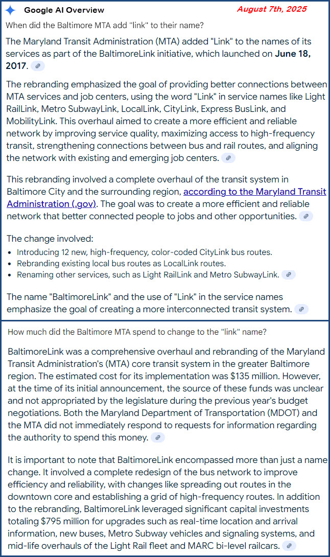
In 2017, the MTA spent close to $150 Million to rebrand "the system", adding
LINK to all of the services. The effort was supposed to make "things"
easier, and present a unified naming approach to the three modes. The MTA
has been severely criticized for spending the taxpayers money without the result
of increasing revenue.
I did two guides for Railpace on railfanning Baltimore. The first came
out in October/November 1990, then they did an update in 2003. Here are a
few notes if you come across the later guides. If you look closely at
the USGS maps for the downtown area in the article, you will notice they are
out of date:
-- I95 and I395 are missing.....
-- I83 does not come down to President St......
-- Riverside yard is shown with a roundhouse (that disappeared in the early
80's with the construction of the Ft McHenry tunnel)......
-- Same thing with the Canton yard on the other side of the harbor - it was
drastically altered with I95 coming thru and their shops was torn down...
-- The Pennsy Orangeville yard and roundhouse is long gone......
-- The Light Rail is not shown at all.....
-- The Western Maryland Port Covington yard is now an industrial complex......
-- The small yard at Camden Station is no longer there, as are the tracks leading up to the B&O Railroad museum......
-- Sep 2005 - Pennsy's High line
-- Oct 2004 - Northern Central history unearthed
-- May 2004 - railfanning the River Line
-- Apr 2004 - River Line grand opening
-- Mar 2004 - Fostoria to Willard OH
-- Feb 2004 - Indiana line to Galatea OH
-- Jun 2003 - Baltimore guide
-- Apr 2003 - Maryland scenic photos
-- Feb 2003 - Harpers Ferry railfan guide
-- Dec 2002 - Amtrak north Philly variety
-- Jan 2002 - New Castle PA railfan guide
-- Jul 2002 - Maryland and Delaware railfan guide
-- Sep 2001 - Tunnel fire in Baltimore
-- May 2001 - railfanning the Canton RR
-- Mar 2001 - Yorkrail roster
-- Oct 2000 - railfanning CSX Hanover sub, PT 2 - Hanover to Hagerstown
-- Jul 2000 - railfanning CSX Hanover sub, PT 1 - Baltimore to Hanover
-- Mar 2000 - CSX DC freight route
-- Feb 2000 - railfanning CSX capital subdivision DC to Baltimore
-- Nov 1998 - Wilmington Amtrak shops -- Oct 1998 - NS Alexandria Sub, Alexandria to Front Royal
-- Sep 1997 - Md Scenic Freight
-- Apr 1997 - railfanning CSX Old Main Line, PT 2 - Woodbine to Halethorpe
-- Feb 1997 - railfanning CSX Old Main Line, PT 1 - Point of Rocks to Mt Airy
Most railroads, because of the Homeland Security crap and the FBI, are weary
of anyone that asks questions about their operations or trains locations. Unless
you know someone that works for a particular railroad, do not expect much
cooperation in most instances.
For instance..... The Maryland
Midland used to be friendly, now they are not. You're not supposed to take
pictures of government buildings, so technically, you can't take pictures at
Penn Station, but in recent years, Amtrak has eased up on the requirement.
As for railroads around Baltimore, the NS
cops are the worst. In places like Philadelphia and Allentown,
they have been known to ticket railfans for stepping on the property at a grade
crossing! (CP Rail's cops are pretty nasty too). The Beth Steel Police
used to get pretty ignorant, but that stems mostly from the industrial espionage aspect of
taking pictures - the companies that are talking their place are almost as bad!
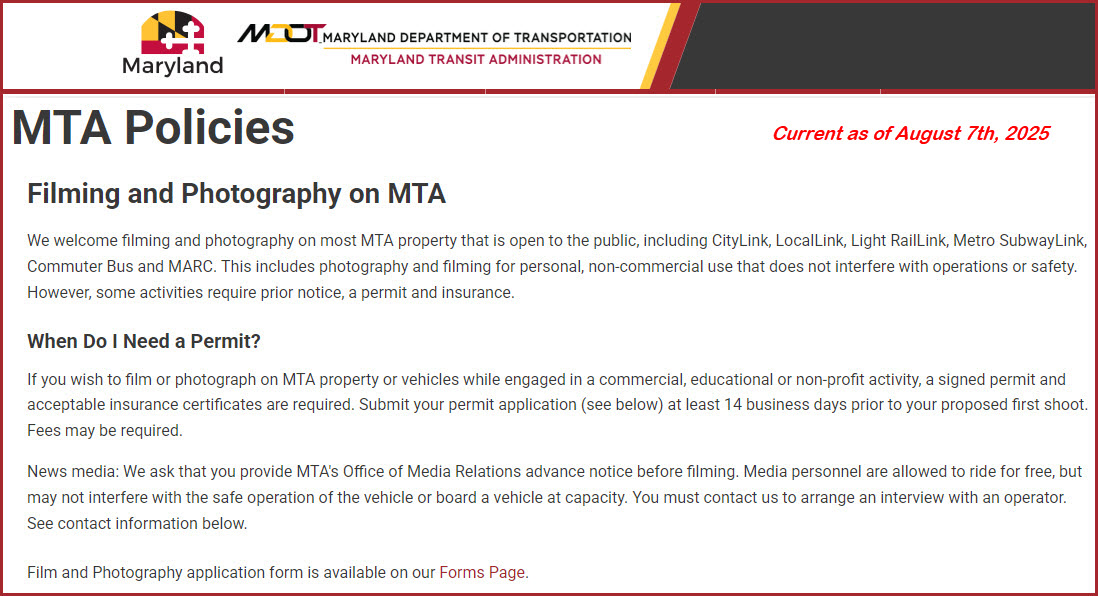
So far, I have never been bothered by the cops on the MTA for
taking pictures, but numerous operators have. In the spring of 2011, a big
"thing" broke out where a guy was harassed by the MTA police, and it turns out
he works for the ACLU. The MTA is still trying to figure out what to do,
but their Public Information Officer said photos were OK... there is no official
policy on their website yet. Lot's
of other transit companies have policies against taking pictures on the
property, like the MBTA in Boston (where I had an operator complain to a ticket
agent once and they chased me off).
There are exceptions if you get around, like the
Minnesota Commercial in St Paul MN -- you can still go in and sign a waiver and
take pictures on the property.
Railroads like the CRANDIC in Cedar
Raids IA.... they don't like railfans, so don't waste your time going by the
office. Worse yet are railroads like the Georgetown in Georgetown TX (small
mining RR north of Austin) -- they just plain HATE railfans, and are willing to
call the police if you even step foot on their parking lot to go in the office
and ask if you can take pictures -- again, don't waste your time. (I do
know of one fellow that did manage to get them to let him take pictures)
So just be careful, and use common
sense. Make a best effort by staying on public property. At least ask someone in
an official capacity before deciding to go on railroad property. We want
everyone to have a good time, cause I'm not available to get you out of jail!