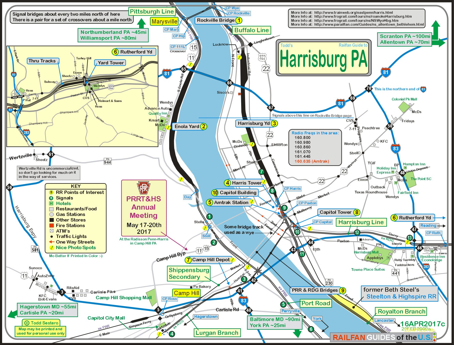
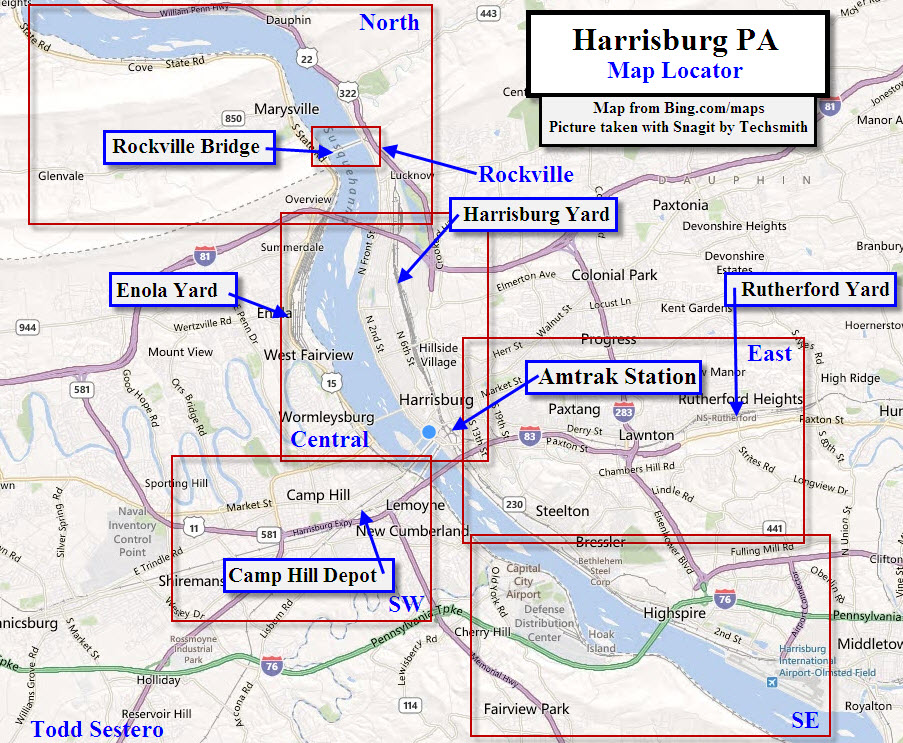
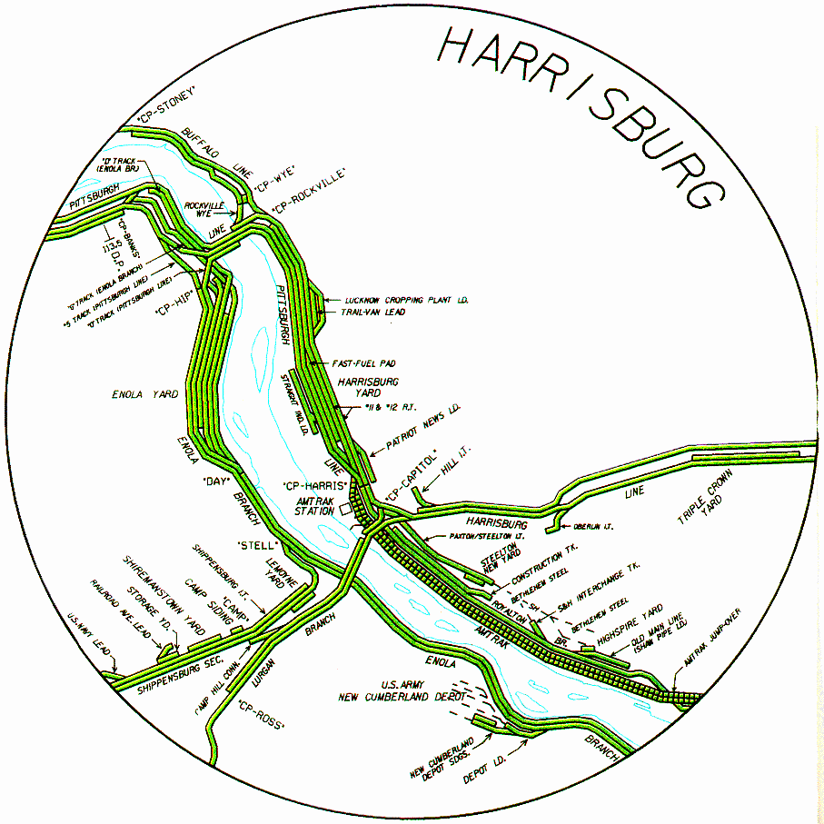
Harrisburg Homepage All of Harrisburg (for now)
Central Harrisburg
Northern Harrisburg
Southwest Harrisburg
East Harrisburg
Southeast Harrisburg Marysville and the Rockville Bridge Please note: I have yet to migrate "stuff" to their separate pages, so everything is still on the old page.....
Harrisburg is a "compact" railfan
town, with most sights you'll want to see not much more than 20 minutes or so away from each
other during non-peak hours. Even during the rush hour traffic, it seems to
move along better than most other cities. The worst traffic I came across
was in leaving Marysville around 6pm, and there was a one mile backup at the
I-81/I-83 interchange going EB, but it was a rolling backup, not really stopping
much. Riding down the western shore of the river is pretty quick using
US15, even during rush hour. Going thru downtown can take a little longer,
but still, all in all, it's not that bad.
Trains
Rails radiating from Harrisburg
head to:
Pittsburgh to the west,
Baltimore to the south via the Port Road and
then Amtrak's NEC at Perryville,
York to the south,
Hagerstown to the southwest,
Reading and Lancaster to the east (and
then onto Allentown (via the Reading) and Philadelphia
(via the Pennsy)), and
Buffalo to the
northwest, via Williamsport.
Amtrak shoots through on the old Pennsy's
Pittsburgh Line, coming from Philadelphia via Lancaster (pronounced LANG-kes-ter),
and then heads north to Duncannon where it heads to Altoona and Pittsburgh.
Now that everything going through
Harrisburg is either Norfolk Southern or Amtrak, railfanning isn't as
much fun as it used to be since the early Conrail days. The Pennsy used to
have most of the action around here, with it's Enola and Harrisburg yards.
The old Northern Central line to
York
and Baltimore
cuts off a couple of miles to the south of these two bridges on the western
shore, but since hurricane Agnes came thru in 1972, thru freights haven't seen
the tracks..... thru freights now go down the Port Road on the east side of the river, and
gets into Baltimore via
Perryville MD.
NS does go down as far as York, but as far as the NC is concerned, nothing has
been down that "branch" since the Stewartstown stopped serving a lumber yard and
the NC Dinner train stopped running back in 1999 (or so).
US15 follows the R-O-W up the west
side for quite some distance, and there are many opportunities for action along
the way. US22 on the other side of the river also follows the tracks well,
but it is a high speed highway, with few places to pull over and shoot.
Notice the absence of anything about
the Steelton and Highspire RR, which is/was one of Bethlehem Steel's railroads.
The last time I went down that way, I didn't see anything running around, and I
can't find much reference to them on the internet. I'll have to try the
phone number I found for them... stay tuned.
Gone are the GG1, E-33 and E-44
electrics, but remnants of the service are evident all over the place,
especially on the Enola side.
Yards
The best of the three yards, without
a doubt, is Enola. Pictures of yard action is easy from US15, which
overlooks much of the yard. If you come off of I81 from the east, you can
also manage to get freights at the very north end of the yard. Enola was
on the western end of Pennsy's electric service, and was reportedly the largest
classification yard on the Pennsy at one time. The Penn Central continued using Enola
in full force, electrics included. Once Conrail took over, they slowly
scaled back the operations there, and killed electric service completely in 1982 :-(
We didn't see it the other day, but
a fellow at the Marysville bed-n-breakfast told us of engine #999, which is ALL
electric, being chock full of batteries instead of a prime mover. If you
see a black and green engine in the yard, that's it!... Update October
2011.... the engine was last seen in Altoona at the Juniata Shops... check
out my Altoona page for pix.
The Reading use to come into
Rutherford yard, a little to the east of downtown. It used to be a
classification yard for the Reading. Conrail pretty much abandoned the
yard, but under Norfolk Southern rule, it has been reconfigured as an intermodal
/ railroader yard.
Harrisburg and Rutherford are much
harder to shoot because there just isn't much in the way of good access... I
don't usually waste much time except at the north end of the Harrisburg yard,
cause there just isn't any easy access to the tracks without getting into
trouble, or the overpass at Rutherford.
Stations
The main station in Harrisburg was
formerly known as the Pennsylvania Station, as many of the Pennsy's stations
were known as. Today, it is known as the Harrisburg Transportation Center,
as oodles of busses come through the stations lot.
More info can be found at
http://www.greatamericanstations.com/Stations/HAR/Station_view
The downtown area around the station
offers a variety of interesting places for photos... take your pick on either
the north or south side.
Over in Camp Hill, there is a surviving depot on the
old Reading line. It is a good spot for pictures, and you also have a
set of pedestrian crossing gates to enhance your photos.
Bridges
There are a number of bridges in the Harrisburg area, but
the area sports probably one of the more famous bridges in Pennsylvania, altho
it has stiff competition with the likes of the Nicholson Viaduct in northern
Pennsylvania. This would be the Rockville bridge a little to the north in
Marysville on the western shore of the Susquehanna River.
Only one of the bridges crossing the
Susquehanna in the downtown area has track on it anymore, the other one has a
short tail track going out on it a couple hundred feet used in turning trains
around.
As far as the Rockville bridge is
concerned, you can good shots from either end, but it's a little easier from the
east side only because it's easier to park. There is also a fishing place
on the western shore just south of the bridge, where you can rent boats by the
half day... Never mind, someone just told me it has been turned into a Bed n
Breakfast... :-(
Towers
When you are downtown, don't forget
to visit the restored Harris Tower, which opened to the public in 2008. It
is usually open on Saturdays, May thru October. I believe the hours are 10
to 3, but make sure you get there well before the closing time, as it is run by
volunteers.
The parking lot adjacent to the
tower is also a good spot for railfanning on the weekends, with freights coming by with a fair
bit of regularity and the areas only searchlight signals. During the week,
the lot is used as parking for PA government staff.
A quick note about signals
Since my main thing is signals, I'm
going to touch on them slightly first.... pictures of most of the signals in
Harrisburg and Camp Hill are towards the bottom of this page. Harrisburg
is smack dab in the middle of Pennsy PL (Position Light) signal territory, yet,
you can find searchlight signals, a lone "tri-light" signal, and the newer color
light installations where PL's and Reading searchlights have been replaced.
Missing though are the Pedestal signals which you find around the Philadelphia
and Baltimore stations, altho a few miles north of Harrisburg (ok, maybe 15
miles) across from Duncannon (where 22 crosses the river), you will come across
the much coveted "red-eye" pedestals. A 45 mile drive to the north will
also take you to Northumberland, where the most unique of all Pennsy PL signals
exist. There are pix of these treasures on my
Pennsy PL Page.
If you go there, I also suggest grabbing lunch or dinner at the train station
restaurant.
Other Stuff :-)
Harrisburg is the capitol of Pennsylvania, and the
capitol building is close to the Harris Tower.
The bridge over the tracks at State Street, next to the
Harris Tower, has some cool columns which you just have to see to believe,
very cool!
The PRRH&TS, PRR Technical & Historical Society has
their annual meeting in Camp Hill every other year in May, on the even
years.
And speaking of Camp Hill, there is a pastry shop there
that I stop by every time I get to the area, excellent stuff!
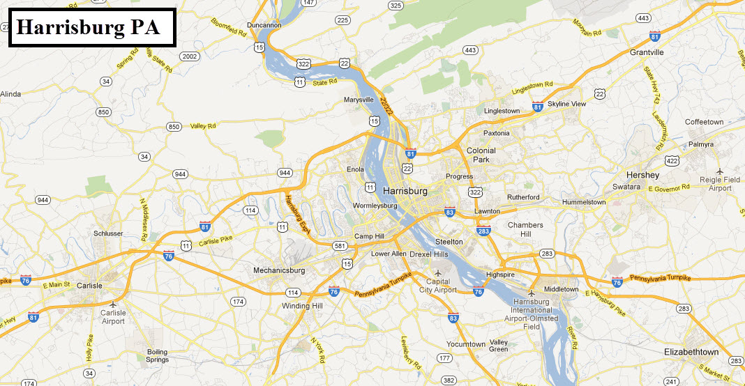
Aerial shots were taken from either Google Maps orwww.bing.com/maps as noted, once in a great while maybe MapQuest. The screen captures are made with Snagit, a
Techsmith product... a great tool if you have never used it!
My RSUS philosophy: Pictures and maps are worth a
thousand words, especially for railfanning. Text descriptions only
get you so far, especially if you get lost or disoriented. Take
along good maps.... a GPS is OK to get somewhere, but maps are still
better if you get lost! I belong to AAA, which allows you to get
local maps for free when you visit the local branches. ADC puts
out a nice series of county maps for the Washington DC area, but their
state maps do not have the railroads on them. If you can find em,
I like the National Geographic map book of the U.S..... good, clear, and
concise graphics, and they do a really good job of showing you where
tourist type attractions are, although they too lack the railroads.
Pictures and additional information is always needed if anyone feels
inclined to take 'em, send 'em, and share 'em, or if you have
something to add or correct.... credit is always given! Contact info
is here
Harrisburg is conveniently located
off of I-81, I-83, and I-76 - the Pennsylvania Turnpike.
I-81 through Harrisburg runs NE to
SW, sort of on a diagonal. Heading south on I-81,
Roanoke VA, home
to the ole Norfolk and Western and an
excellent railfanning city, is about 4hrs away (exit 125 in VA) and
Hagerstown MD
is less then an hour away (exit 6 in MD).
Going "north" on I81, it runs almost due east from
Harrisburg till I-78 splits off (at exit 89), then heads north to
Wilkes-Barre (exit 170) and
Scranton,
which is
about two hours away to exit 185 - this exit will take you to downtown and
Steamtown!
I-78 is only 20 miles to the east
off I-81 (off the map), and
will take you to Allentown (a little over an hour away at exit 57), Bethlehem PA (exit 67), and then on to
NYC. On the way to I-78, you will pass the home of
Hershey's Chocolate (exit 77) and the Hershey
Amusement Park! About halfway to Allentown you will go by the
northern end of the Blue Mountain and Reading in
Hamburg (exit 29).
I-76 runs east-west, and runs from
Philadelphia to the Ohio border. Pittsburgh is about 3 - 3 1/2 hours to the
west,
and Philadelphia is about 2 1/2 hours
to the east. It is a toll road.
One of these days I will have a set
of maps and guides taking you all the way from Philadelphia to Pittsburgh, for
now, the following stuff available to follow the ex Pennsy
mainline: