RAILFAN GUIDES of the U.S.
Todd's Railfan Guide to
ALTOONA - PA
Including Horseshoe
Curve and Gallitzin
In General
Maps
Additional Links
RAILFAN GUIDES HOME
RAILROAD SIGNALS HOME
The guides for the Altoona area are
divided into the following pages:
Altoona Area Index Page
Altoona
Proper
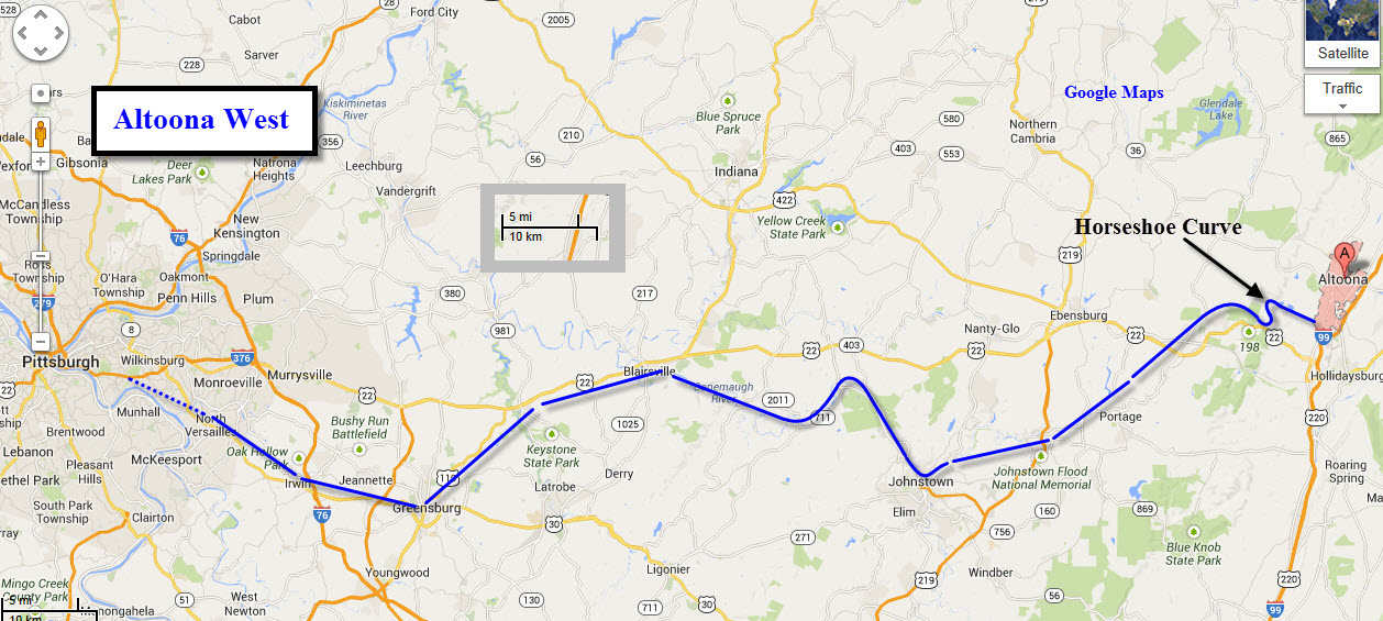
Altoona West
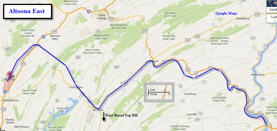
Altoona East
Horseshoe
Curve
Gallitzin
Cresson
the East Broad Top RR
Railfan Guide
the
Rockhill Trolley Museum
This set of guides covers the Altoona and Horseshoe Curve areas, concentrating on those two, but covering the area from Mt Union to the east, and South Fork on the south, or west side.
Altoona sits at just about the halfway point between Harrisburg and Pittsburg. The maps below reflect this.
This area is probably on every railfans bucket list of places to visit, and is well worth the time and effort to get here and take it all in... you won't be disappointed! Especially in the fall when the trees are turning, which is usually around mid October.
To the west of Altoona, once "up on the ridge" west of Gallitzin, the area is relatively easy to railfan for the most part, as route 53 follows the tracks fairly well, and the terrain is fairly flat.
On the other side of Altoona, heading east towards Mt Union, the route isn't always as easy to railfan, but there are still some spots easy to access from US22.
Obviously, the big draw for the area is Horseshoe Curve, but there are countless other things to do and see while here.
Note: If you like Pennsy signals, the PL signals in the downtown area are gone, along with the decommissioning of ALTO tower. This happened over the summer in 2012. The rest are soon to follow.
If you're in the area for more than a day, you may also want to think about stopping at the East Broad Top Railroad, about 35 miles to the east by way of US 22.
And speaking of the EBT, both them
and the Railroaders Museum have special railfan events. The Museum has its
Railfest days, and on the last weekend of operation for the year, the EBT has
their fall spectacular, where everything they have that runs, is running.
It is a rare occurrence for them to happen on the same weekend, which would make
it really convenient for the railfan, but that hasn't happened in recent memory,
for the Museum has started having the Railfest days during the summer.
Unfortunately, since NS took over Conrail, they have opted out of holding an
open house. Conrail used to do a great job of showing off to the public.
A pair of Pennsy E-8's regularly show up at Railfest days, numbers 5711 and
5809, owned by Bennett Levin, and have been known to pull the excursion trains
over the hill to Gallitzin.
Websites and other
additional information
sources of interest for
the area:
Another good railfan site for the
Altoona area:
http://www.trainweb.org/horseshoecurve-nrhs/Guide.htm
Some good ole B&W photos of Altoona by Roy Orr, provided by
Pat Pritchett:
http://prr.railfan.net/photos/Altoona/
General PRR info by Rob Schoenberg:
http://prr.railfan.net/
If you like Levin's E's, they appear on the covers of Railpace Magazines OCT
2001 and JUN 2002, and I'm sure lots of others!
Disclaimers:
I love trains, and I love signals. I am not an expert. My webpages reflect what I find on the topic of the page. This is something I have fun with while trying to help others. My webpages are an attempt at putting everything I can find of the subject in one convenient place. There are plenty of other good websites to help me in this effort, and they are listed in the links section on my indexa page, or as needed on individual pages. Please do not write to me about something that may be incorrect, and then hound the heck out of me if I do not respond to you in the manner you would like. I operate on the "Golden Rule Principle", and if you are not familiar with it, please acquaint yourself with how to treat people by reading Mathew 7:12 (among others, the principle exists in almost every religion). If you contact me (like some do, hi Paul) and try to make it a "non-fun" thing and start with the name calling, your name will go into my spambox list! :-)
Please Note: Since the main focus of my two websites is railroad signals, the railfan guides are oriented towards the signal fan being able to locate them. For those of you into the modeling aspect of our hobby, my indexa page has a list of almost everything railroad oriented I can think of to provide you with at least a few pictures to help you detail your pike.
If this is a railfan page, every effort has been made to make sure that the information contained on this map and in this railfan guide is correct. Once in a while, an error may creep in, especially if restaurants or gas stations open, close, or change names. Most of my maps are a result of personal observation after visiting these locations. I have always felt that a picture is worth a thousand words", and I feel annotated maps such as the ones I work up do the same justice for the railfan over a simple text description of the area. Since the main focus of my website is railroad signals, the railfan guides are oriented towards the signal fan being able to locate them. Since most of us railheads don't have just trains as a hobby, I have also tried to point out where other interesting sites of the area are.... things like fire stations, neat bridges, or other significant historical or geographical feature. While some may feel they shouldn't be included, these other things tend to make MY trips a lot more interesting.... stuff like where the C&O Canal has a bridge going over a river (the Monocacy Aqueduct) between Point of Rocks and Gaithersburg MD, it's way cool to realize this bridge to support a water "road" over a river was built in the 1830's!!!
My philosophy: Pictures and maps are worth a
thousand words, especially for railfanning. Text descriptions only
get you so far, especially if you get lost or disoriented. Take
along good maps.... a GPS is OK to get somewhere, but maps are still
better if you get lost! I belong to AAA, which allows you to get
local maps for free when you visit the local branches. ADC puts
out a nice series of county maps for the Washington DC area, but their
state maps do not have the railroads on them. If you can find em,
I like the National Geographic map book of the U.S..... good, clear, and
concise graphics, and they do a really good job of showing you where
tourist type attractions are, although they too lack the railroads.
Other notes about specific areas will show up on that page if known.
By the way, floobydust is
a term I picked up 30-40 years ago from a National Semiconductor data
book, and means miscellaneous and/or other stuff.
Pictures and additional information is always needed if anyone feels
inclined to take 'em, send 'em, and share 'em, or if you have
something to add or correct.... credit is always given! BE NICE!!! Contact info
is here
Beware: If used as a source, ANYTHING from Wikipedia must be treated as being possibly being inaccurate, wrong, or not true.
RAILFAN GUIDES HOME
RAILROAD SIGNALS HOME