RAILFAN GUIDES of the U.S.
Todd's Railfan Guide to
BALTIMORE MD
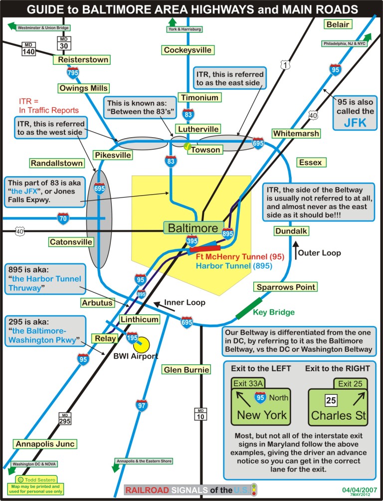
The Highways around Baltimore
RAILFAN GUIDES HOME
RAILROAD SIGNALS HOME
Guide Home Maps History Hiways Hotels Intro Railroad Sights Links Photos Busses Bio's
Station & Depots Yards Museums Other Sights
The Interstates.....
Baltimore is conveniently located at the
junction of I-70 (east/west), I-83 (north/south), and I-95 (north/south).
These are all connected by a loop around the city called the
Beltway, or, the
Baltimore Beltway in order to distinguish itself from the one around
DC. It is also known as I-695. Three letter interstate designations
are routes into or around a city. In Atlanta, they call the same thing the
Perimeter, and in Texas, they call 'em
Loops. When they talk about accidents on
the Beltway in traffic reports, they will also refer to the inner loop, or the
outer loop, hopefully self explanatory.
I-70 ends just inside the Beltway, and from there, it heads west to beyond Hagerstown MD, where it goes northward to join up with the Pennsylvania Turnpike at Breezewood. Baltimore is actually the eastern terminus for I-70.
I-83 goes almost due north out of Baltimore and connects with I-76 and I-81 in the Harrisburg PA area, and you pass through York PA along the way. I-83 ends in Baltimore by the Police HQ and the Shot Tower at Franklin St. From the Beltway north, it is also known as the Harrisburg Expressway. From the Beltway south into Baltimore, it is also known as the JFX, or the Jones Falls Expressway.
I-95 is the major north-south interstate of the eastern seaboard, from it, you have access to Philadelphia, New Jersey, New York City and beyond, and to the south, Washington DC, Richmond and Petersburg VA, NC, SC, and beyond. On the north side, it is also known as the JFK. Below Baltimore, I-95 also gets you access to I-66 in DC, I-64 in Richmond, and I-85 below Richmond. Above Baltimore, it meets up with I-76 (the Pennsy Turnpike) in Philly, and the Garden State Parkway in upper NJ. I-95 is one of two interstates that goes through the city. To get under the harbor, it goes through the Fort McHenry Tunnel (it opened in 1985, is 7200 feet long, and has 4 lanes in both directions). The toll booth is on the north side, and is convenient to the Canton area railroad stuff.
I-97 on the south side of Baltimore goes from the Beltway and heads "down to" Annapolis MD, and then on to the eastern shore and the Delmarva Peninsula, via US-50 and the Bay Bridge.
I-195 is a short stub going from I-95 into BWI Airport. It turns into MD166 going in the other direction into Catonsville.
I-395 is a short stub that takes you from I-95 where it passes over the harbor, and into the downtown area.
I-795 is a local feeder to the Beltway on the NW side and runs about 10 miles up to Reisterstown where MD 140 continues on to Westminster, and MD30 heads north to Hanover PA.
I-895 is what used to be the original way to get across Baltimore before the interstate system got it's start, and is also known as the Harbor Tunnel Thruway. It goes from I-95 on the south side just above RT100, follows I-95 on a fairly parallel route through the city, comes up in Canton right next to I-95, continues north till it joins back up with I-95 about halfway between the Beltway and downtown. The big disadvantage with 895, is that on the way to the tunnel on both ends, there are no exits except for Bayview medical center on the northside - once your on it, you are on it till you go thru the tunnel. This is left over from the old days when it was easier to not build more tollbooths at every exit (as they do in Richmond on the Powhite, for instance). The tunnel, BTW, is the Harbor Tunnel - it's 7650 feet long, 2 lanes in each direction, and opened in 1957. The toll booth is on the south end of the tunnel.
A note about traffic reports on Baltimore radio stations and XM/Sirius....
For some reason, when "they" mention the eastern side of the Beltway, they are usually referring to the Perring Parkway to I-95 stretch on the northern side, rarely to the real eastern side around Eastpoint Mall and Bethlehem Steel.
"Between the 83's" is referring to the one mile stretch between the two junctions of I-83, and is usually a major PIA in rush hour traffic with people criss-crossing to get from one route to the other... avoid at all costs if you can!
Non-Interstate Roads.....
MD-295, the Baltimore-Washington Parkway, runs from downtown Baltimore to inside the DC Beltway. It's only two lanes in each direction, and sometimes gets easily clogged up. The nice thing about it is that trucks can not use it.
US-40 runs east/west, and goes thru Baltimore. On the north side of town, it parallels I-95 and is known as Pulaski Highway. On the west side of B'more, it follows I-70 for about 8 miles before it junctions with I-70, and is known as "40 west". The majority of I-70 is from that point west is what used to be US-40.
US-1 runs north/south, and parallels I-95 on the south side, and heads up to Philly on the north side away from I-95. Train stuff can be found on the south side of town along US-1, AKA Route 1.
MD10 is an interstate quality road running from the Beltway on the SE side, well down into Anne Arundel County. It's mainly a feeder like I-795.
There are obviously many local arterial roads, like York Rd, Charles St, Belair Rd, Frederick Rd, which are too numerous to be noted here, but will be on my individual maps.
If you have any comments, contributions, addition, questions, whatever.......... https://railroadsignals.us/contact.htm
new in 2003
Last Modified:
02/16/2014