In General
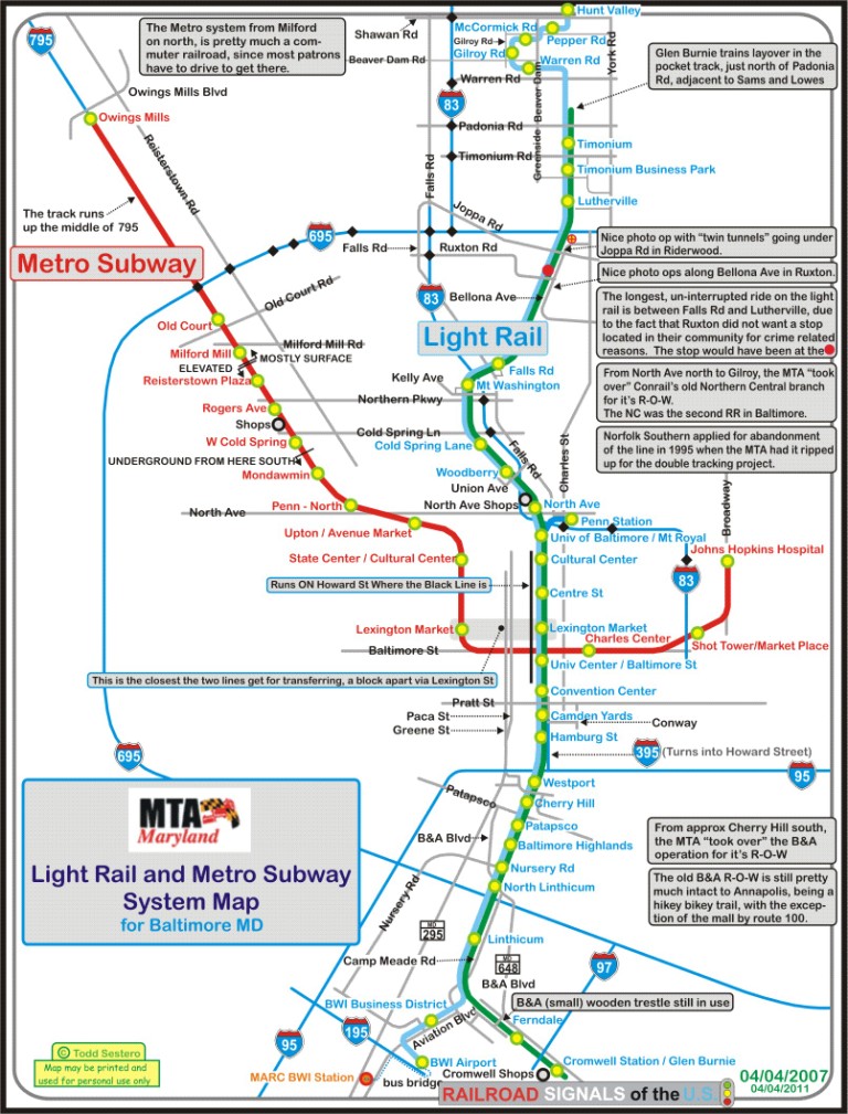
Map
Station by Station Pages:
Hunt Valley to Lutherville
Lutherville to North Avenue
North Avenue to
Westport + the Middle Branch Bridge
Westport to Cromwell
Penn Station and BWI Airport
RAILROAD SIGNALS HOME
Location / Name:
Baltimore MD to Hunt Valley MD
Baltimore MD to Glen Burnie MD
Baltimore MD to BWI Airport
What's Here:
Baltimore's Light Rail System
Data:
GPS Coordinates: as needed
Phone A/C: 410
ZIP: 21201 (downtown Baltimore)
Access by train/transit:
The Light Rail System itself
Amtrak at Penn Station
MARC at Camden Station
The Scoop:
Baltimore's Light Rail System is about 30 miles long with 33 stations, from "top to bottom" - Hunt Valley to Glen Burnie (Cromwell Station) and BWI Airport.
There is a variety of interesting subject matter to satisfy the needs of almost any transit and/or railroad fan. The main Light Rail shops is located in what used to be Pennsylvania Railroad's Mt Vernon Yard. Near there, the R-O-W passes over CSX and Amtrak's NEC going underneath it in B&P Tunnel. There, we pass by the location of the B&O's former NA tower. The tracks from there, go south on Howard Street, where the hustle and bustle of "old" Baltimore used to be at the top of it's game 60 years ago, all the while, the tracks are directly over CSX's Howard Street Tunnel. Then we get to one of the first stations in America, Camden Yards. Heading further south, we pass over the inlet on a massive bridge to get to (the other side :-) Westport. For the remainder of the trip south to Cromwell, the LRV's are running on the old Baltimore & Annapolis R-O-W.
From the main shops heading north, the R-O-W travels on the former PRR / Northern Central line, which started out as the Baltimore & Susquehanna RR, Baltimore's second railroad. We pass thru the former Robert E. Lee park (yeah, I know, it's not PC :-) where Lake Roland is located, and it is the longest stretch of track between stations - Falls Road and Lutherville, some 4 miles or so. North of Lutherville, we pass thru Texas, where the trains run past a quarry where the stone for the Washington Monument in D.C. came from! Once the trains make a sharp left turn at Warren Road, the trains are then running on the industrial park trackage for about half the trip thru Hunt Valley.
There is obviously, a lot to see, if you know where to look for it, that's why I started my Railfan Guide to Baltimore in 2005, to make it easy for you to find this "stuff".
Because of the large number of stations, and all of the other interesting stuff to see along the way, I have divided up this section covering the stations into 5 separate pages, cause they are all picture intensive. See the list above.
Acknowledgements:
Google Maps
Bing Maps
John Engleman
Denver Todd
Debbie Bode Sestero
Barbara "Babs" Bode
Websites and other additional information sources of interest for the area:
None for now.....
Disclaimers:
I love trains, and I love signals. I am not an expert. My webpages reflect what I find on the topic of the page. This is something I have fun with while trying to help others.
Please Note: Since the main focus of my two websites is railroad signals, the railfan guides are oriented towards the signal fan being able to locate them. For those of you into the modeling aspect of our hobby, my indexa page has a list of almost everything railroad oriented I can think of to provide you with at least a few pictures to help you detail your pike.
If this is a railfan page, every effort has been made to make sure that the information contained on this map and in this railfan guide is correct. Once in a while, an error may creep in :-)
My philosophy: Pictures and maps are worth a thousand words, especially for railfanning. Text descriptions only get you so far, especially if you get lost or disoriented. Take along good maps.... a GPS is OK to get somewhere, but maps are still better if you get lost! I belong to AAA, which allows you to get local maps for free when you visit the local branches. ADC puts out a nice series of county maps for the Washington DC area, but their state maps do not have the railroads on them. If you can find em, I like the National Geographic map book of the U.S..... good, clear, and concise graphics, and they do a really good job of showing you where tourist type attractions are, although they too lack the railroads. Other notes about specific areas will show up on that page if known.
Aerial shots were taken from either Google or Bing Maps as noted. Screen captures are made with Snagit, a Techsmith product... a great tool if you have never used it!
By the way, floobydust is a term I picked up 30-40 years ago from a National Semiconductor data book, and means miscellaneous and/or other stuff.
Pictures and additional information is always needed if anyone feels inclined to take 'em, send 'em, and share 'em, or if you have something to add or correct.... credit is always given! Please be NICE!!! Contact info is here
Beware: If used as a source, ANYTHING from Wikipedia must be treated as being possibly being inaccurate, wrong, or not true.
RAILFAN GUIDES HOME
RAILROAD SIGNALS HOME
NEW JUL01/2020, JUL06/2020, SEP06/2020
Last Modified 06-Sep-2020