RAILFAN GUIDES HOME RAILROAD SIGNALS HOME
This page will cover the stations of the Baltimore Light Rail System
starting just south of the North Avenue station going under North Avenue, and
heading south to downtown Baltimore, across the Middle RIver, and into Westport. I
will also cover the grade crossings and anything else of importance.
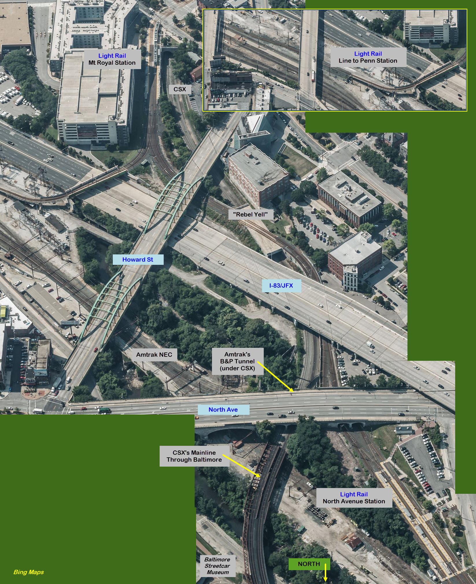
Going Under North Avenue
Over CSX and Amtrak
The folks at Light Rail call this the Rebel Yell, after the roller
coaster ride at King's Dominion (but I guess that is going to have to change
now, as of 2020, with all of the brew-ha-ha going on).
Univ of Baltimore / Mt Royal Avenue
GPS Coordinates: 39.307391, -76.619894
Diverging point for trains going to Penn Station.
Cultural Center Station
GPS Coordinates: 39.303675, -76.620455
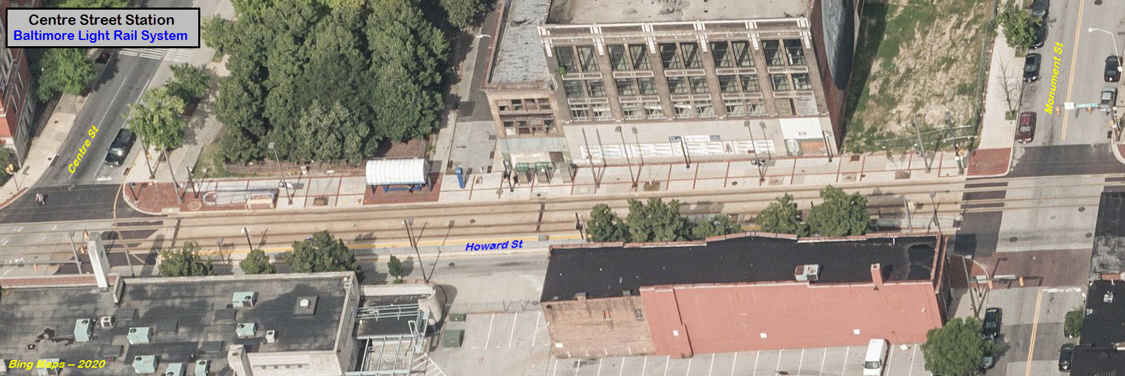
Centre Street Station
GPS Coordinates: 39.296259, -76.619903
Just north of this station, light rail turns onto Howard Street for it's run
through the downtown area, it's a mess, I wish they would have picked a side of
the street to run on and stayed on it! :-) The NB and SB platforms are
not across from each other here, as also done at the Lexington Market station.
For the stations along Howard Street, there is not much in the way of
trackside scenery to make one stand out from any of the others,
except for maybe the Convention Center....
Lexington Market Station
GPS Coordinates: 39.292079, -76.619622
This is one of a handful of stations where the platforms are offset from each other.
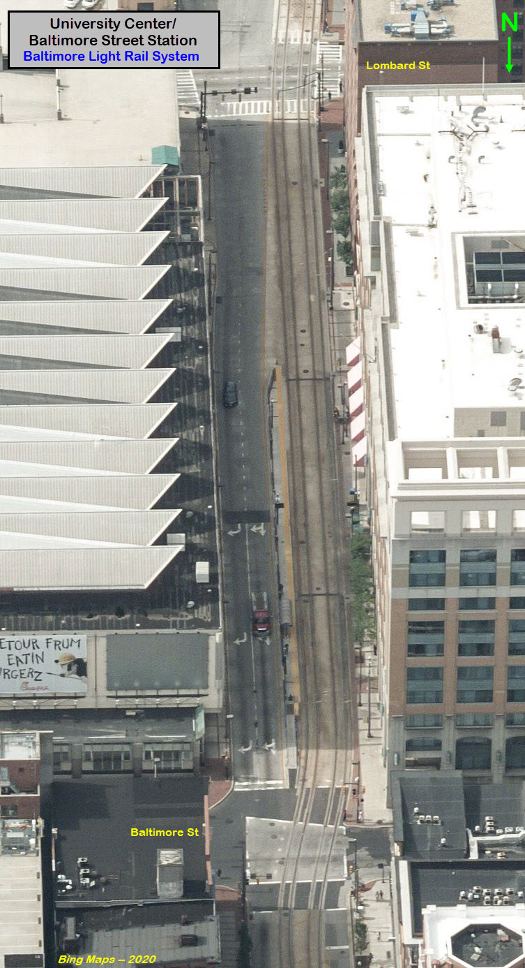
University Center / Baltimore Street Station
GPS Coordinates: 39.288840, -76.619442
Convention Center / Pratt Street Station
GPS Coordinates: 39.285734, -76.619390
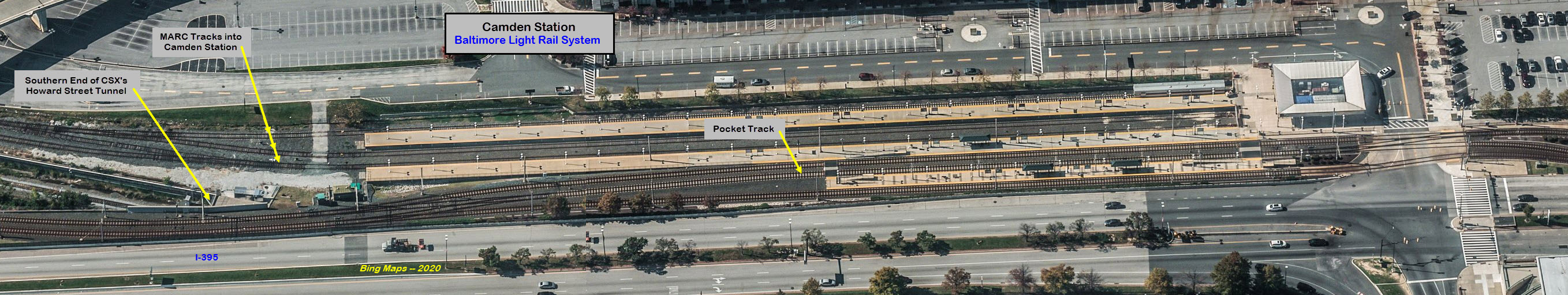
Camden Yards Station
GPS Coordinates: 39.283086, -76.619375
Camden Yards is one of only two stations where you can transfer to another form
of rail transportation, the other is Penn Station.
One of three places you will find a pocket track, the others are at North Avenue
and Timonium Station Rd.
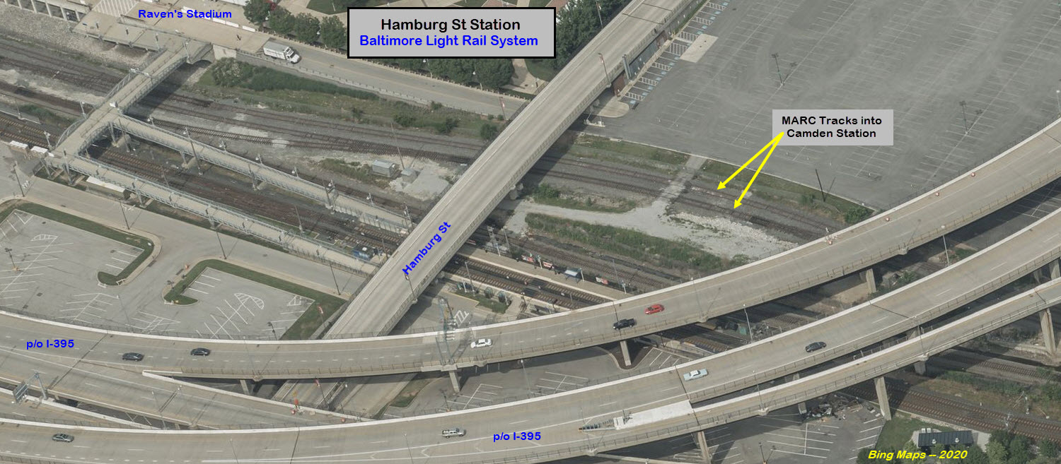
Hamburg Street Station
GPS Coordinates: 39.279033, -76.619883
This stationed originally opened as a station just for football games, but
around (maybe) 2004, it became a full time station.
It's kind of funny, how the MTA added a pocket track at Camden Station to handle
the extra trains for baseball games, but they usually only run 2-packs on game
nights, while on football game nights, they don't have a pocket track at Hamburg
Street, but they usually run 3-packs :-).
A long time ago, the MTA committed to staying on their printed schedule, instead
of increasing the number of inbound or outbound trains to MOVE PEOPLE like the
streetcar systems did "back in the old days", I guess metrics is more important
than moving people efficiently!
Over CSX's Bailey's Wye and the Middle Branch/Patapsco River
Probably the most expensive structure on the entire light rail system, maybe
even costing more than the two maintenance facilities. It was originally
put in as a single track bridge, with room for a second track. The second
track was added when they double tracked the southern portion of the line, from
downtown south. The Middle River bridge is responsible for many operators
going back to Bus-side, or waiting for their seniority to build so they can pick
into the Metro side - a lot of them don't like going over the water! I
don't know if you still can, but you used to be able to get good shots from the
southern shore. If you want to pull over for a quick shot, try the I-395
leaving downtown, you're up over the light rail line. Adjacent to CSX's
Bailey's Wye is also a good spot for pictures.
Going over Bailey's Wye
If you take exit 52 from SB I-95, to get on SB Baltimore-Wash Parkway, you can get a
shot like this. After looking at the photo below, I would ask WHY isn't the entire system designed like the
bridge, where the catenary poles are in the middle of the two tracks, instead of
using two poles to support the wires when the tracks are on the ground. It
costs more, and takes up more real estate.... I don't get it???
The next three shots are taken from the far right outbound I-395 interchange
lane that will head north on I-95 to Delaware...
Disclaimers:
I love trains, and I love signals. I am not an expert. My webpages reflect what I find on the topic of the page. This is something I have fun with while
trying to help others.
Please Note: Since the main focus of my two websites is railroad signals, the railfan guides are oriented towards the signal fan being able to locate them.
For those of you into the modeling aspect of our hobby, my indexa page has a list of almost everything railroad oriented
I can think of to provide you with at least a few pictures to help you detail your pike.
If this is a railfan page, every effort has been made to make sure that the information contained on this map and in this railfan guide is correct. Once in a while,
an error may creep in :-)
My philosophy: Pictures and maps are worth a thousand words, especially for railfanning. Text descriptions only get you so far, especially if you get lost or
disoriented. Take along good maps.... a GPS is OK to get somewhere, but maps are still better if you get lost! I belong to AAA, which allows you to get
local maps for free when you visit the local branches. ADC puts out a nice series of county maps for the Washington DC area, but their state maps do not have the
railroads on them. If you can find em, I like the National Geographic map book of the U.S..... good, clear, and concise graphics, and they do a really good job
of showing you where tourist type attractions are, although they too lack the railroads. Other notes about specific areas will show up on that page if known.
Aerial shots were taken from either Google or Bing Maps as noted. Screen captures are made
with Snagit, a Techsmith product... a great tool if you have never used it!
By the way, floobydust is a term I picked up 30-40 years ago from a National Semiconductor data book, and means miscellaneous
and/or other stuff.
Pictures and additional information is always needed if anyone feels inclined to take 'em, send 'em, and share 'em, or if you have something to add or correct.... credit
is always given! Please be NICE!!! Contact info is here
Beware: If used as a source, ANYTHING from Wikipedia must be treated as being possibly being inaccurate, wrong, or not true.


 Going over Bailey's Wye