In General
Getting Here
Map
Sights
Pictures
the Subways
New York City Subway System
Staten Island RR
PATH
Car Float Operations
Signals
Floobydust
RAILFAN GUIDES HOME
RAILROAD SIGNALS HOME
Location / Name:
New York City NY, AKA, the Big Apple
I typically list the county a particular town or city is in, however, with New York City, NYC is made up of five (5) Burroughs/Counties:
-- Manhattan / New York County,
-- Queens/Queens County,
-- Bronx/Bronx County,
-- Brooklyn/Kings County,
-- Staten Island/Richmond County.
What's Here:
Freight Lines:
-- CSX
-- NS
-- New York and Atlantic Rwy (includes operations on the LIRR)
-- North Shore Branch (Staten Island RR)
Car Float Operations:
-- New York New Jersey Rail
Passenger and Commuter Service:
-- Amtrak
-- Metro North
-- Long Island RR
-- New Jersey Transit
-- Airtrain JFK People Mover (there's a people mover at Newark Airport too)
Subway Systems:
-- the New York City Subway System
-- PATH
Stations (major):
-- Atlantic Terminal (LIRR/Brooklyn)
-- Grand Central Terminal (GCT)
-- Jamaica (LIRR/Queens/it's a BIG one!)
-- Penn Station
Bridges and Tunnels:
-- 14th Street Tunnel (Subway/BMT Canarsie Line)
-- 53rd Street Tunnel (Subway/IND Queens Blvd Line)
-- 60th Street Tunnel (Subway/BMT)
-- 63rd Street Tunnel (LIRR)
-- 63rd Street Tunnel (Subway/IND 63rd Street Line)
-- 149th Street Tunnel (Subway/IRT White Plains Rd Line)
-- Arthur Kill Vertical Lift Bridge (NJ to Staten Island)
-- Atlantic Ave Tunnel (LIRR/Brooklyn)
-- Bay Ridge Branch Tunnel, about 3,000ft long in Brooklyn under the subway
-- Clark Street Tunnel (Subway/IRT Broadway-Seventh Ave Line)
-- Concourse Tunnel (Subway/IND Concourse Line)
-- Cranberry Street Tunnel (Subway/IND Eighth Ave Line)
-- Downtown Hudson Tubes (PATH)
-- East River Tunnels (Amtrak/LIRR/NJT)
-- Harlem River Lift Bridge (Metro North)
-- Hellgate Bridge (Amtrak and NY&ARR (former New Haven)
-- Joralemon Street Tunnel (Subway/IRT Lex Ave Line)
-- Lexington Ave Tunnel (Subway/IRT Lexington Ave Line)
-- Montague Street Tunnel (Subway/BMT Broadway Line)
-- Manhattan Bridge (Subway + auto/BMT Brighton Line)
-- North River Tunnels (Amtrak/NJT)
-- Rutgers Street Tunnel (Subway/IND Sixth Ave Line)
-- Steinway Tunnel (Subway/IRT #7 Flushing Line)
-- Uptown Hudson Tubes (PATH)
-- Williamsburg Bridge (Subway + Auto/BMT Jamaica Line)
-- Williams Bridge (Metro North/Bronx/over East Gun Hill Rd)
Yards:
-- 10th Ave Yard (Subway/BMT/Brooklyn)
-- 36th Street Yard (Subway/BMT/Brooklyn/half mile from the 10th Ave Yard))
-- 51st Street Yard (Brooklyn)
-- 65th Street Yard (Brooklyn/connects to the Bay Ridge Branch NYARR))
-- E 180th Street Yard (Subway/IRT/Bronx (next to Unionport Yard))
-- 207th Street Yard (Subway/Manhattan)
-- 239th Street Yard (Subway/IRT/Bronx)
-- 240th Street Yard (Subway/IND A/Bronx)
-- Arch Street Yard (LIRR/Queens)
-- Arlington Yard (Staten Island)
-- Blissfield Yard (Queens)
-- Brooklyn Navy Yard
-- Bushwick Yard (NYARR/Brooklyn)
-- Canarsie Yard (Subway/BMT/Brooklyn)
-- Clifton MUE Yard (Subway/SIR/Staten Island)
-- Concourse Yard (Subway/IND/Bronx)
-- Culver yard (Subway/Brooklyn)
-- East New York Yard (Subway/BMT Jamaica Line/Brooklyn/junction of the BMT Carnarsie Line, BMT Jamaica Line, IND Fulton St Line)
-- Fresh Pond West Yard (NYARR/Queens)
-- Fresh Point East Yard (NYARR/Queens)
-- Fresh Pond Road Yard (NYARR/Queens)
-- Harlem River Yards (Bronx)
-- Highbridge Yard (Bronx)
-- Hillside Yard/Facility (LIRR/Queens)
-- Holban Yard (LIRR/Queens)
-- Jamaica Yard (Subway/IND/Queens)
-- Jerome Yard (Subway/IND/Bronx)
-- Lennox Ave Yard (Manhattan)
-- Linden Yard (Subway/Brooklyn)
-- Livonia Yard (Subway/IRT/Brooklyn)
-- Long Island City Yard (Queens)
-- Maspeth Yard (NYARR/Brooklyn)
-- Mets-Willets Point Yard (Subway/IRT #7 Line/Queens)
-- Morris Park Facility (LIRR Shops with turntable/Jamaica-Queens)
-- Mott Haven Yard (Metro North/inside the Hudson River & Harlem Branch Lines Junction)
-- Mount Vernon Street Yard (Metro North/Bronx)
-- NYC Produce Terminal Market in Hunts Point (Bronx)
-- Oak Point Yard (CSX/NYARR/Bronx)
-- Pikin Yard (Subway/IND/Brooklyn)
-- Richmond Hill Yard (NYARR/LIRR)
-- Rockaway Park Yard (Subway/IND/Brooklyn)
-- Sunnyside Yard (Long Island City/Queens)
-- Unionport Yard (Subway/IRT/Bronx)
-- VD Yard (Brooklyn)
-- Westchester Ave Yard (Subway/IRT/Bronx)
-- Wheelspur Multimodal Facility and Freight Yard (Queens)
Wyes:
-- SIR at St George (Staten Island)
-- Metro North Hudson River & Harlem Lines Junction (near E 149th St and Grand Concourse/Bronx)
-- Fresh Pond Junction (Where the NY&ARR HQ is)
Turntables:
-- Morris Park Facility (LIRR Shops with turntable/Jamaica-Queens)
Museums:
-- New York Transit Museum (Brooklyn)
Note: Not counting the freight line into Staten Island - which doesn't serve any other part of NYC, the closest Hudson River crossing for freight isn't until you get to almost Albany, with the Albert Smith Memorial Bridge; ~122 miles north of Penn Station, or ~10 miles south of Albany. It is a two-track bridge carrying the Castleton Sub of CSX. There is also the two-track Livingston Avenue Bridge right in Albany that crosses the Hudson at Quay/Colonie Streets that is part of Metro North's Hudson Line. Governor Hochul announced in early 2026 that the state will not pursue an extension into Albany at this time.
Data:
GPS Coordinates: as needed
Access by train/transit:
Take your pick:
- Amtrak into Penn Station
- the New York City/MTA Subway and Bus system
- Metro-North commuter rail into Grand Central Terminal
- New Jersey Transit commuter rail into Penn Station
- PATH Subway System
- the Long Island Railroad commuter rail into Penn Station and now Grand Central Terminal (service began 2025)
The Scoop:
There is so much railfan stuff to see and do in New York City, no ONE guide can cover it all - it would be a small encyclopedia! With that said, I will cover various aspects of train and transit operation in the five Boroughs, and touching on the surrounding area in Westchester County, Long Island, New Jersey, and Connecticut as needed.
As you can see from the above list of railroad oriented sights, it's almost like going over a list of items for the Chicago area!
What you do when you visit New York, will depend on what you want to get pictures of. For freight fans, there is not quite as much going on as other cities, because for the Queens, Brooklyn, and Long Island, the only way in and out is over the Hell Gate bridge - and throughput is limited because Conrail removed one of the two freight tracks over the bridge.
Websites and other information for the area:
A trip report on my trip to NYC on National Train Day 2012 - almost all subway stuff: https://railroadsignals.us/trips/trip3/index.htm
A trip report on a trip to NYC in 2014 to see Dave Letterman - lots more subway stuff: https://railroadsignals.us/trips/trip6/index.htm
A trip to NYC via commuter and light rail: https://railroadsignals.us/trips/trip7/index.htm
https://en.wikipedia.org/wiki/Rail_freight_transportation_in_New_York_City_and_Long_Island
https://en.wikipedia.org/wiki/Car_float
https://en.wikipedia.org/wiki/New_York_New_Jersey_Rail
The guide is divided into the following sections (so far):
the Bronx
Brooklyn
Manhattan
the Queens
-- Hell Gate Bridge
-- Sunnyside Yard
-- Jamaica Station
Staten Island
-- the Staten Island Rapid Transit
Getting to G
It can't get much better than this for someone into trains and planes! :-)
A shot from Google Streetview at the tail end of Sunnyside Yard, adjacent to 53rd Street, kinda under 11th St. I don't know if any of it is active, but there is "exposed" third rail at some of the street crossings here in the neighborhood.
https://en.wikipedia.org/wiki/New_York_City_Subway
https://en.wikipedia.org/wiki/Independent_Subway_System
https://en.wikipedia.org/wiki/Interborough_Rapid_Transit_Company
https://en.wikipedia.org/wiki/Brooklyn%E2%80%93Manhattan_Transit_Corporation
https://en.wikipedia.org/wiki/PATH_(rail_system)
https://en.wikipedia.org/wiki/Staten_Island_Railway
It is damn near impossible to come to New York City and NOT have an experience on the subway.
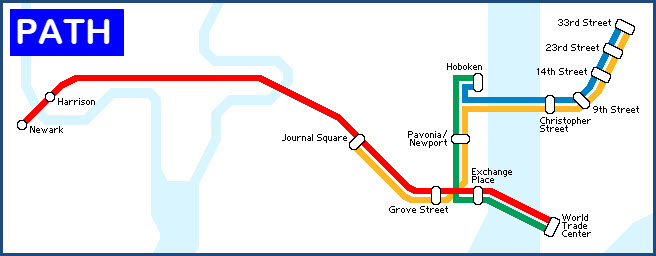
And before we start with a breakdown of the New York City Subway System, there is one other subway system that comes into New York City: PATH. PATH is a northern New Jersey subway system that starts in Newark NJ and comes into NYC via two (2) tunnels - it has six (6) stations in NYC - five (5) served by a northern branch, and the World Trade Center station served by a separate southern tunnel. See more below.
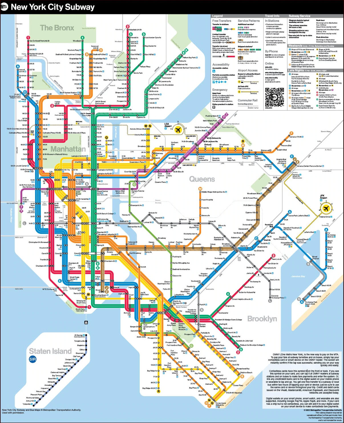
-- The New York City Subway System
Although NOT the largest system in the world (depending on how you rate "largest"), it is very close to the number one spot on the list of subway/metro systems!
Today's subway system in New York is operated by the Mass Transit Administration, which was called the New York City Transit Authority (NYCTA) until 1994.
It is AKA the New York City Transit, or just the Transit Authority (TA).
The subway system as we know it today is a mixture of three pioneering systems: the IRT, the BMT, and the IND.
-- The first subway system to be built in 1904 was the IRT. It was a private company. IRT was short for the Interborough Transit Company.
-- Also built as a private company was the BMT, or the Bronx-Manhattan Transit Company. Incorporated in 1923.
-- The IND was a city owned venture, known as the Independent Subway System. It started out life as the Eighth Avenue Line in 1932. Additionally: Until 1940, it was known as the Independent City-Owned Subway System (ICOS), Independent Subway System (ISS), or Independent City-Owned Rapid Transit Railroad. It became known as the IND after unification of the subway lines in 1940; the name IND was assigned to match the three-letter initialisms that the IRT and BMT used. (From Wikipedia)
The train routes still use the original route designations that they carried almost from the beginning. The IRT uses numbered routes, and the BMT and IND use letter designations - the IND using "lower" letters (A, B, E, F for example), and the BMT uses "higher" letters (M, N, Q, R for example).
The three systems were merged together when the subway system was unified in 1940. Although the three systems lost their individual ownership at that time, they are still today, often referred (by mostly New Yorkers) with their original IRT, BMT, and IND identifiers.
The system runs in four of the five boroughs: Manhattan, Bronx, Queens, and Brooklyn.
Staten Island has it's own system called SIR (small compared to the rest of the system), or what most of still call SIRT (because it sounds better) for the Staten Island Rapid Transit. It is a subsidiary of the MTA. It's one line with 21 stations. Covered below.
-- The Staten Island Railroad
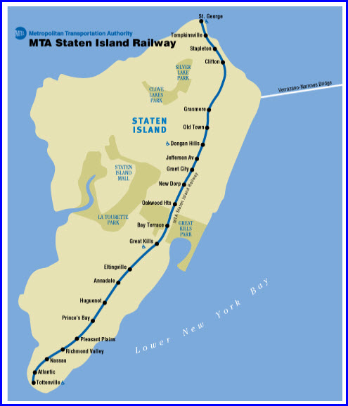
Although the Staten Island Railroad falls under the MTA umbrella, it is still it's own
-- The PATH Subway System
https://en.wikipedia.org/wiki/New_York_New_Jersey_Rail
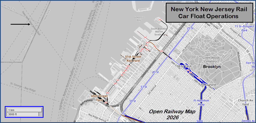
Only one car float operator remains in the New York City area today, and it is New York New Jersey Rail.
From Wikipedia: New York New Jersey Rail, LLC (reporting mark NYNJ) is a switching and terminal railroad[1] that operates the only car float operation across Upper New York Bay between Jersey City NJ and Brooklyn NY. Since mid-November 2008, it has been owned by the Port Authority of New York and New Jersey, which acquired it for about $16 million as a step in a process that might see a Cross-Harbor Rail Tunnel completed.
Since freight trains are not allowed in Amtrak's North River Tunnels, and the Poughkeepsie Bridge was closed in 1974, the ferry is the only freight crossing of the Hudson River south of the Alfred H. Smith Memorial Bridge, 140 miles (230 km) to the north of New York City, in a process known as the Selkirk hurdle.[2] It is the last remaining car float operation in the Port of New York and New Jersey.[3]
The railroad operates in two divisions, the Marine division and Port Jersey Rail division.[4] Its switching operations on the New York side include a short spur north to Bush Terminal which runs through the Brooklyn Army Terminal complex and then through the center of First Avenue in Sunset Park.[5] This spur is the last example of active street-running rail operations in New York City. end wiki (see the Wikipedia page for the parenthetic references)
Signals will be covered on each individual page.
Got nuttin for now..... How about YOU??? If you have anything to contribute, please shoot me an email!
Disclaimers:
New format 10/26/23: Please check out my disclaimer page for my standard dribble and contact info here
RAILFAN GUIDES HOME
RAILROAD SIGNALS HOME
NEW 07/07/2016, APR09/10/2026
Last Modified 10-Apr-2026