RAILFAN GUIDES HOME RAILROAD SIGNALS HOME
Coverage of the DC Metro system is split up into individual pages for each line:
the Blue Line the Green Line the Orange Line the Red Line the Silver Line the Yellow Line
This page covers the DC Metro's Blue Line.
On the south side, the line starts at Franconia/Springfield VA,
runs along with the Yellow line from King St to the Pentagon
station, then runs along the west side of the river to join up
with the Orange and Silver lines prior to Rosslyn. The three lines
then go under the Potomac River, snake their way through the downtown
area, and then split after the Stadium-Amory station, with the
Blue line continuing to Largo with the Silver line.
From Wikipedia: The Blue Line is a rapid transit line of
the Washington Metro system, consisting of 27 stations in Fairfax
County, Alexandria and Arlington VA; the District of Columbia;
and Prince George's County MD. The Blue Line runs from Franconia–
Springfield to Largo Town Center. The line shares tracks with the
Orange Line for 13 stations, the Silver Line for 18, and the
Yellow Line for six. Only three stations are exclusive to the
Blue Line. end Wiki
Stations without an aerial picture do not
have any discernable features from the air.
Acknowledgements:
Open Street Map
Ben Shuman
EmilyHaHa
Google Maps
Bing Maps
Wikipedia
GPS Coordinates: 38.900485,-76.84443
https://en.wikipedia.org/wiki/Downtown_Largo_station
Station is above ground/elevated. Area so-so for railfans.
Huge parking garage available (and it fills up!)
Station serves the Blue and Silver lines. Current end of the line.
Easy to get to off of I-495/I-95, and MD214, Central Avenue.
It is the first and so far the only station in Prince George's County outside the Capital Beltway
This station is the only terminus that has two lines terminating at it.
Station opened on 18DEC2004.
GPS Coordinates: 38.893655,-76.868312
https://en.wikipedia.org/wiki/Morgan_Boulevard_station
Station is at ground level in an open cut.
Not a great area for railfans.
Good size parking lot available.
Station serves the Blue and Silver lines.
The line is in tunnels about half the way to both Largo and Addison stations.
Morgan Blvd. is one of the few stations not served by Metrobus, however,
PG County's "TheBus" serves the station.
Station opened on 18DEC2004.
GPS Coordinates: 38.886223, -76.896486
https://en.wikipedia.org/wiki/Addison_Road_station
Station is (kinda) at ground level.
Not a good area for railfans. However, it has a huge parking garage available.
Station serves the Blue and Silver lines.
Station opened on 22NOV1980.
Addison was the end of the Blue Line until 2004, when the Morgan and Largo stations opened.
GPS Coordinates: 38.88953,-76.913438
133 Central Avenue
https://en.wikipedia.org/wiki/Capitol_Heights_station
Station is underground, under East Capitol Street NE.
Not a good area for railfans.
Station serves the Blue and Silver lines.
The station opened on November 22, 1980, and coincided with the completion
of 3.52 miles (5.66 km) of rail east of the Stadium–Armory station and the
opening of the Addison Road and Benning Road stations.
This is the first station on the two lines in Maryland going east.
Silver Line service at Capitol Heights began on July 26, 2014.
GPS Coordinates: 38.890379,-76.937752
https://en.wikipedia.org/wiki/Benning_Road_station
Station is underground, between Benning Road and East Capitol St SE.
Not a good area for railfans.
Station serves the Blue and Silver lines.
This is the last station on the two lines in DC going east.
The station opened on November 22, 1980, and coincided with the completion
of 3.52 miles (5.66 km) of rail east of the Stadium–Armory station and
the opening of the Addison Road and Capitol Heights stations.
GPS Coordinates: 38.89619, -76.95237
Under Benning Road NE and DC295.
Blue Line train crosses the D Route bridge east of Stadium-Armory station in Washington DC
Picture from Wikipedia, taken by Ben Schumin, 25OCT2005
Map below shows where the above picture was taken.
GPS Coordinates: 38.885901, -76.977167
https://en.wikipedia.org/wiki/Stadium%E2%80%93Armory_station
Station is underground, under 19th Street SE.
So-so area for railfans.
Station serves the Blue, Orange, and Silver lines.
The Orange Line splits off after this station (going east), once on the other
side of the Anacostia River.
Station serves RFK Stadium.
The station opened on 1JUL1977, coinciding with the completion of 11.8 miles
(19.0 km) of rail between National Airport and RFK Stadium.
This was the end of the line until the extension opened on November 22, 1980.
GPS Coordinates: 38.880844,-76.98545
https://en.wikipedia.org/wiki/Potomac_Avenue_station
Station is underground, under Potomac Avenue.
Not a good area for railfans.
Station serves the Blue, Orange, and Silver lines.
The station opened on 1JUL1977, coinciding with the completion of 11.8 miles
(19.0 km) of rail between National Airport and RFK Stadium.
GPS Coordinates: 38.884118, -76.994966
https://en.wikipedia.org/wiki/Eastern_Market_station
Station is underground, under Pennsylvania Ave SE.
Not a good area for railfans.
Station serves the Blue, Orange, and Silver lines.
The station opened on 1JUL1977, coinciding with the completion of 11.8 miles
(19.0 km) of rail between National Airport and RFK Stadium.
GPS Coordinates: 38.885713, -77.005942
https://en.wikipedia.org/wiki/Capitol_South_station
Station is underground.
Area OK for railfans.
Station serves the Blue, Orange, and Silver lines.
Orange Line service to the station began upon the line's opening on November 20, 1978.
The station opened on 1JUL1977, coinciding with the completion of 11.8 miles
(19.0 km) of rail between National Airport and RFK Stadium.
GPS Coordinates: 38.885008, -77.01556
https://en.wikipedia.org/wiki/Federal_Center_SW_station
Station is underground, under D Street SW.
Area OK for railfans.
Station serves the Blue, Orange, and Silver lines.
The station opened on 1JUL1977, coinciding with the completion of 11.8 miles
(19.0 km) of rail between National Airport and RFK Stadium.
GPS Coordinates: 38.885008, -77.01556
https://en.wikipedia.org/wiki/L%27Enfant_Plaza_station
Station is underground. Area OK for railfans.
Station serves the Blue, Orange, and Silver lines. Transfer to the Green and Yellow Lines.
The station opened on 1JUL1977, coinciding with the completion of 11.8 miles
(19.0 km) of rail between National Airport and RFK Stadium.
Block away from the VRE/Amtrak L'Enfant Station and CSX freight line going to Virginia.
The FAA, FCC, Federal Transit Administration, and NTSB HQ's are nearby.
McDonalds and Holiday Inn nearby.
From Wikipedia: L'Enfant Plaza station is an Intermodal transit station complex located at
L'Enfant Plaza in the Southwest Federal Center neighborhood of Washington D.C. It consists
of an underground Washington Metro rapid transit station and an elevated Virginia Railway
Express (VRE) commuter rail station.
The Metro station, which opened on July 1, 1977, is one of four major interchange stations
on the Metro system. It is the only station to serve five of the six Metro lines: the Green
and Yellow lines with two side platforms on the upper level, and the Blue, Orange, and
Silver lines with one island platform on the lower level. It was the seventh-busiest Metro
stop in 2023, with an average of 7,506 daily passenger entries.
The VRE station, which has a single side platform serving the northernmost of the three tracks
of the RF&P Subdivision, is served by the Manassas Line and Fredericksburg Line. end wiki
GPS Coordinates: 38.887676, -77.028258
https://en.wikipedia.org/wiki/Smithsonian_station
Station is underground, under Jefferson Drive SW.
Station serves the Blue, Orange, and Silver lines.
Area OK for railfans.
The station opened on 1JUL1977, coinciding with the completion of 11.8 miles
(19.0 km) of rail between National Airport and RFK Stadium.
This station is near:
-- Washington Monument
-- Smithsonian Museum
-- The Mall
-- U.S. Holocaust Memorial Museum
-- Museum of Natural History
-- Museum of American History
-- National Gallery of Art
-- National Air and Space Museum
-- And much more!
GPS Coordinates: 38.893839, -77.028043
https://en.wikipedia.org/wiki/Federal_Triangle_station
Station is underground, under 12th Street NW.
Area OK for railfans.
Station serves the Blue, Orange, and Silver lines.
The station opened on 1JUL1977, coinciding with the completion of 11.8 miles
(19.0 km) of rail between National Airport and RFK Stadium.
GPS Coordinates: 38.898348, -77.028043
https://en.wikipedia.org/wiki/Metro_Center_station
Station is underground, under 12th Street NW.
Area OK for railfans.
Station serves the Blue, Orange, and Silver lines. Transfer to the Red Line.
The Red Line portion of Metro Center station opened on 27MAR1976, as part of the first section of the Metro system.
GPS Coordinates: 38.901462, -77.03227
https://en.wikipedia.org/wiki/McPherson_Square_station
Station is underground. Area OK for railfans.
Station serves the Blue, Orange, and Silver lines.
The station opened on 1JUL1977, coinciding with the completion of 11.8 miles
(19.0 km) of rail between National Airport and RFK Stadium.
GPS Coordinates: 38.901349, -77.039555
https://en.wikipedia.org/wiki/Farragut_West_station
Station is underground, under I street NW.
Area OK for railfans.
Station serves the Blue, Orange, and Silver lines.
NO transfer to the Red Line at Farragut North - transfers to the Red Line
can be made two stops away (towards downtown DC) at the Metro Center station.
The station opened on 1JUL1977, coinciding with the completion of 11.8 miles
(19.0 km) of rail between National Airport and RFK Stadium.
GPS Coordinates: 38.900706,-77.050166
https://en.wikipedia.org/wiki/Foggy_Bottom%E2%80%93GWU_station
Station is underground, under I street NW.
Area OK for railfans.
Station serves the Blue, Orange, and Silver lines.
The station opened on 1JUL1977, coinciding with the completion of 11.8 miles
(19.0 km) of rail between National Airport and RFK Stadium.
GPS Coordinates: 38.895482,-77.072064 https://en.wikipedia.org/wiki/Rosslyn_station
Station is underground, under North Lynn Street.
Area OK for railfans.
Station serves the Blue, Orange, and Silver lines.
Hyatt Hotel, Courtyard Hotel near, and Metro Mall here.
McDonalds, Quizno's, and Starbucks all nearby.
The Orange and Silver lines split off south of here.
On the north side of the station, the line goes under the Potomac River to enter DC.
The station opened on 1JUL1977, coinciding with the completion of 11.8 miles
(19.0 km) of rail between National Airport and RFK Stadium.
GPS Coordinates: 38.884523, -77.063228
https://en.wikipedia.org/wiki/Arlington_Cemetery_station
Station is at ground level in an open cut.
Area OK for railfans.
The station is one of three stations to be exclusively serviced by the Blue Line.
The station opened on 1JUL1977, coinciding with the completion of 11.8 miles
(19.0 km) of rail between National Airport and RFK Stadium.
NOTE: There is no public parking near the station except at the cemetery,
which is reserved for cemetery visitors.
NOTE: It is the only station that closes earlier than the rest of the system,
closing at 7 PM from October to March, and 10 PM from April to September.
GPS Coordinates: 38.869464,-77.053825
https://en.wikipedia.org/wiki/Pentagon_station
Station is underground. Area probably NOT OK for railfans due to DOD
security concerns.
Station serves both the BLUE and YELLOW lines, the lines split just north of the station.
The station opened on 1JUL1977, coinciding with the completion of 11.8 miles
(19.0 km) of rail between National Airport and RFK Stadium.
GPS Coordinates: 38.862969,-77.059243
https://en.wikipedia.org/wiki/Pentagon_City_station
Station is underground. Area OK for railfans.
Station serves both the BLUE and YELLOW lines.
The station opened on 1JUL1977, coinciding with the completion of 11.8 miles
(19.0 km) of rail between National Airport and RFK Stadium.
GPS Coordinates: 38.857973,-77.050853
https://en.wikipedia.org/wiki/Crystal_City_station_(Washington_Metro)
Station is underground. Area OK for railfans.
Station serves both the BLUE and YELLOW lines.
You catch the VRE from here.
The station opened on 1JUL1977, coinciding with the completion of 11.8 miles
(19.0 km) of rail between National Airport and RFK Stadium.
South Tunnel Portal
GPS Coordinates: 38.85769, -77.04632
Tunnel portal is about 1,300ft north of the Reagan/National Airport station.
GPS Coordinates: 38.853077, -77.043879
https://en.wikipedia.org/wiki/Ronald_Reagan_Washington_National_Airport_station
Station is above ground/elevated. Area OK for railfans.
Station serves both the BLUE and YELLOW lines.
The station opened on 1JUL1977, coinciding with the completion of 11.8 miles
(19.0 km) of rail between National Airport and RFK Stadium.
Prior to almost everything that is here now, the RF&P (Richmond, Fredericksburg
& Potomac RR) operated a classification yard here from 1906 to 1989. They
actually closed the yard two years before CSX absorbed the RF&P.
photo: Carol M. Highsmith/1980
North Tunnel Portal
GPS Coordinates: 38.82517, -77.046402
Tunnel portal is about 2,600ft south of the Potomac Yard station.
South Tunnel Portal
GPS Coordinates: 38.81907, -77.05008
Tunnel portal is about 2,100ft north of the Braddock Rd station.
GPS Coordinates: 38.813998,-77.053728
https://en.wikipedia.org/wiki/Braddock_Road_station
Station is above ground/elevated. Area OK for railfans.
Station serves both the BLUE and YELLOW lines.
The station opened on 17DEC1983. Its opening coincided with the
completion of 4.2 miles (6.8 km) extension between National Airport and Huntington.
GPS Coordinates: 38.806373,-77.061324
1900 King St, Alexandria VA
https://en.wikipedia.org/wiki/King_Street%E2%80%93Old_Town_station
The station is at ground level. The area is -kinda- OK for railfans.
Station serves both the BLUE and YELLOW lines. The Yellow and Blue lines split just south of the station.
The Amtrak and VRE Alexandria station are co-located here.
The station opened on 17DEC1983. Its opening coincided with the
completion of 4.2 miles (6.8 km) extension between National Airport and Huntington.
GPS Coordinates: 38.803867, -77.06754 (center of, at the tennis courts)
This is where the Yellow and Blue lines split. The wye portion is so
trains have an easy way to get to/from the shops, which are on the
Blue Line, to the end of the Yellow line, which is where trains
typically start or finish their "day". PS: technically, it IS a wye,
but is not used in the traditional roll of turning trains around.
GPS Coordinates: 38.799283,-77.128723 https://en.wikipedia.org/wiki/Van_Dorn_Street_station
Station is on the surface.
Area is OK for railfans.
Station services the Blue Line ONLY.
Van Dorn is the only Washington Metro station to be named after a Confederate general.
Norfolk Southern tracks run parallel to the Metro here, after the Metro crosses over the NS just north of here.
The station opened on 15JUN1991, with the completion of 3.9 miles (6.3 km) of track west of the King Street/Old Town station.
GPS Coordinates: 38.766114,-77.168806
https://en.wikipedia.org/wiki/Franconia%E2%80%93Springfield_station
Station is on the surface, and shares the land with a VRE station by the same name.
Station services the Blue Line ONLY.
Only station on the south end that is outside the DC Beltway.
Exit off the Franconia Expy just for the station, however, there doesn't appear to
be a northbound exit for the station from I-95?
Very large parking garage here.
CSX's RF&P Sub-Division's tracks run parallel to the Metro here.
Area OK for railfans, but you need to watch yourself :-).
Station opened on 29JUN1997, its opening coincided with the completion of 3.3 miles
(5.3 km) of rail west of the Van Dorn Street station.
Ben Schumin via Wikipedia
Disclaimers:
New format 10/26/23: Please check out my disclaimer page for my standard
dribble and contact info here


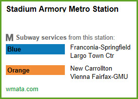
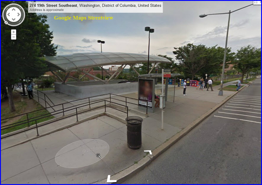


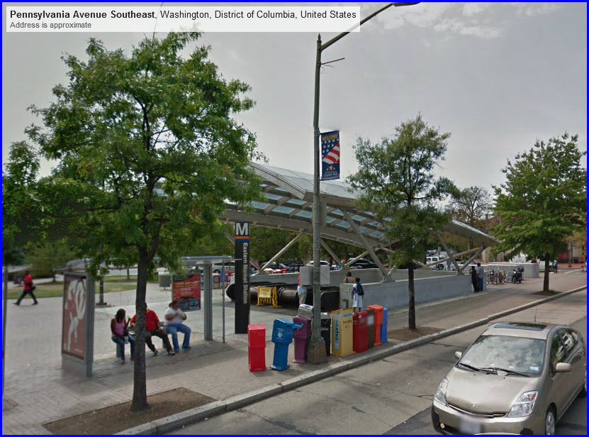

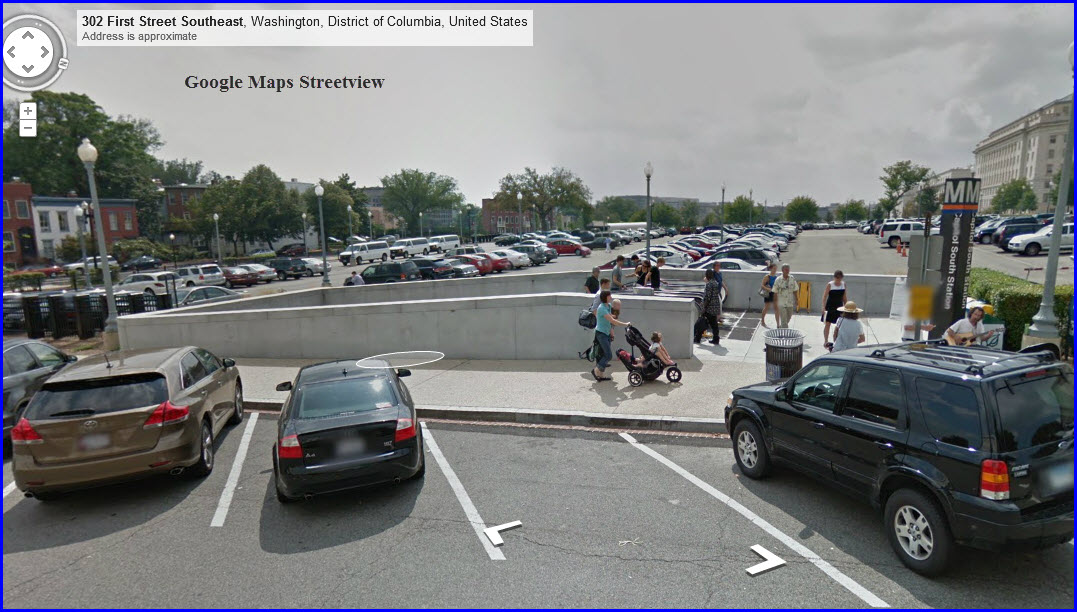

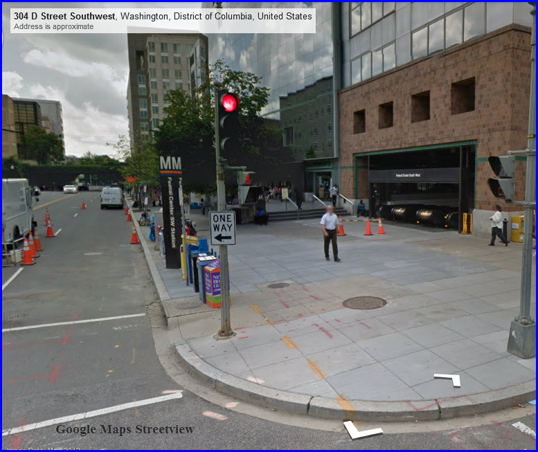


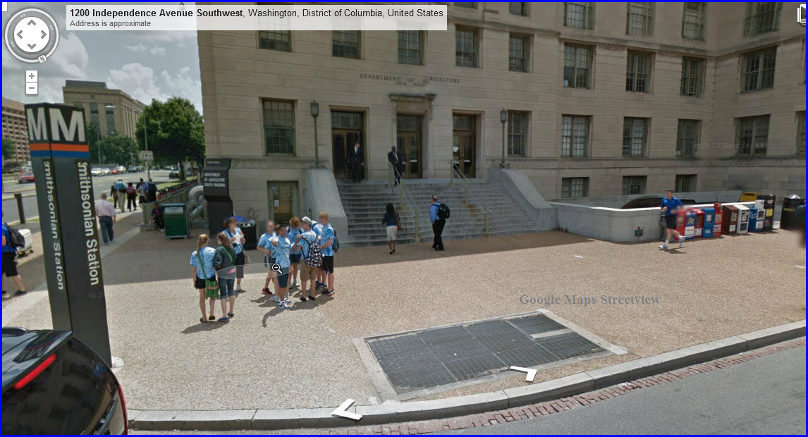

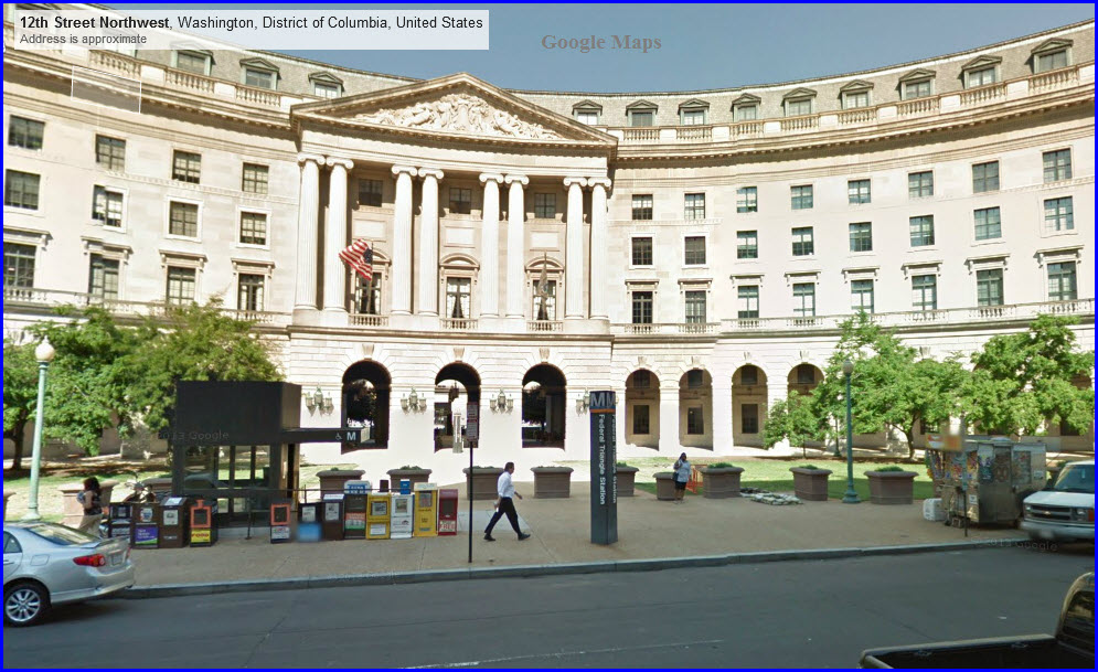

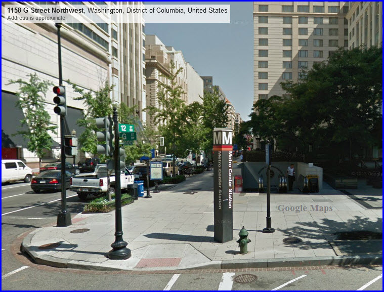


 photo by Ben Shumin, 9FEB2005.


 WMATA picture
 from Metro Wire & Cable page
 photo: Carol M. Highsmith/1980


 Ben Schumin via Wikipedia
