RAILFAN GUIDES of the U.S.
Todd's Railfan Guide to
WASHINGTON DC
the Highways of DC
RAILFAN GUIDES HOME
RAILROAD SIGNALS HOME
DC Guide Home Railroads Hiways Hotels Intro Railroad Sights Links Photos Transit Busses
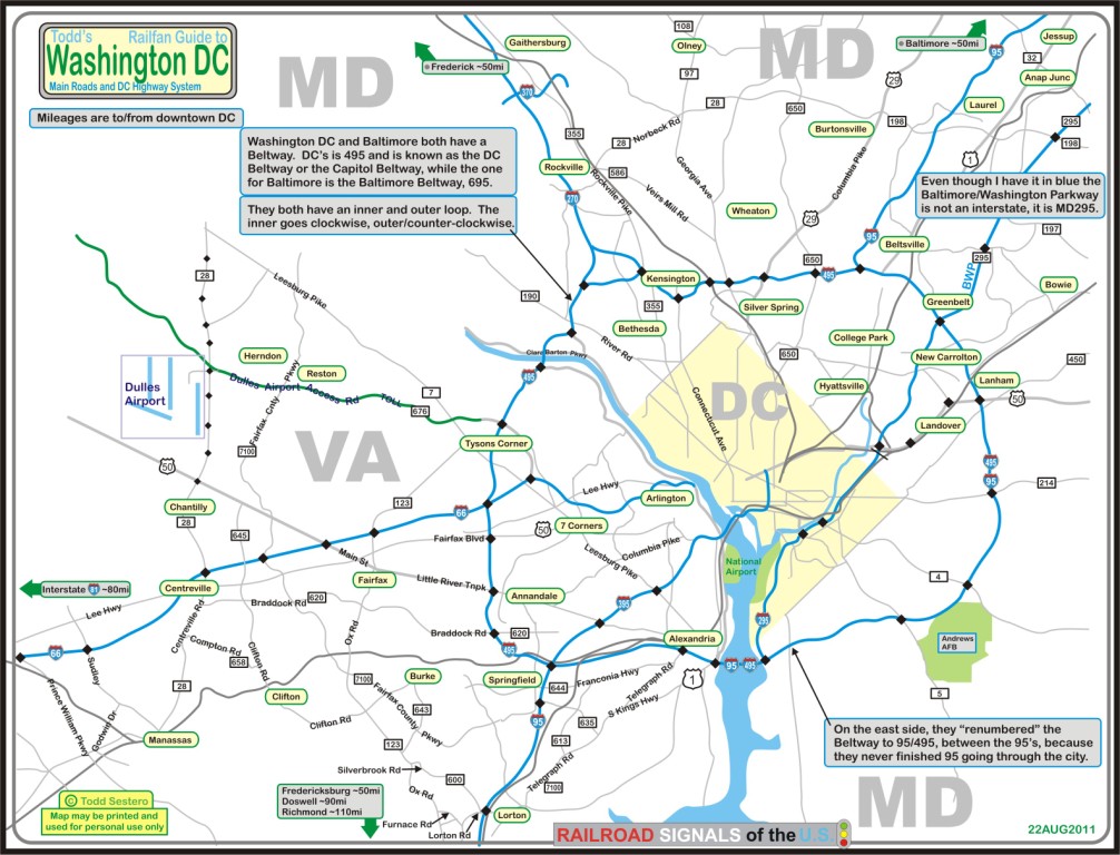
The map below shows the visitor to DC the main roads and highways.
I-495 is the Beltway, or Capitol Beltway to distinguish itself from the Baltimore Beltway.
I-270 is a feeder interstate between Frederick MD and the DC Beltway on the NW side.
I-66 comes off the DC Beltway on the west side, and heads over to I-81 just on the other side of Front Royal VA.
I-95 is the main N-S highway thru the region. It was supposed to go THRU DC, but the property was never acquired to make it a reality, it would have displaced too many section 8 residents.
So, as a result of this government SNAFU, I-395 heads north from the south side of the Beltway, into downtown Washington DC.
Somewhere around 2000 or so, the bright highway engineers decided to rename the section of the Beltway ("between the 95's" on the east side) from just I-495, to I-95/I495, so people would have some coherency in their trip if they were travelling I-95. I guess they figured the common man wouldn't be able to figure it out! :-(
I-370 is a short piece of interstate in the Gaithersburg area. Dunno why they couldn't have given it some state number, but I guess they got federal funds for it.
MD-295 runs parallel with I-95 between Baltimore and DC, and the is a growing trend to call the part inside DC, I-295.
There is a new "cross-county" connector, MD-200, running between I-95 and I-270 on the west side, BUT BEWARE, it is a toll road.
US 1 also runs north-south, parallel to I-95 and MD-295, and generally runs up the middle of those two. South of DC, it runs to the east of I-95, and is one alternative to 95 when it turns into a parking lot.
US 29 runs kinda north-south too, going from, like, the 1:30 to 8:00 positions of DC. It goes west out of DC to Warrenton VA, where it then heads south to Charlottesville VA and further.
US 50 is an east-west highway, and takes you to Annapolis on the east, and Parkersburg WV and Cincinnati OH to the west. It is one rugged road thru West Virginia, and I for one am glad to see the interstate take it's place!
U.S. Interstate highway FAQS:
Even numbered highways run east-west. They are numbered starting in the south, with I-4 shooting across central Florida, to I-90 being the northernmost interstate to run across the whole country. I-94 pops up in two places north of I-90 (Michigan, and thru Minneapolis and Bismark-rejoins up with I-90 on the west side), and I-96 runs across Michigan.
Odd numbered highways run north-south. They are numbered starting in the west, with I-5 running up the coast of California north to Seattle, and I-95 running up the east coast from Florida to Maine. I-97 runs for a short distance south out of Baltimore.
I-99 throws the numbering scheme out of whack, running south out of Altoona to the PA Turnpike.
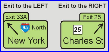
The great majority, but not all interstate exit signs, give you a clue as to which side of the highway the exit will be on as shown in the picture below.
Most interstates are now numbered by the mile marker they are closest to, New York may still be one of the states using consecutive exit numbers, Pennsylvania dropped their consecutive exit numbering maybe around 2000 or so.
Mile markers are numbered from either the southern or western side of the state.
Even three digit interstate numbers go around a city, like I-495 goes around Washington DC, and I-695 goes around Baltimore. The base number is always one of the major interstates that come thru or into the city. Interstate I-270 is an exception to the rule. I-270 was originally I-70S, and I-70 from Frederick to Baltimore used to be I-70N! :-)
Odd three digit numbers are routes that go into a city, such as I-395, where I-95 on the southside of DC continues north into downtown DC.
New
02/17/2008
Last Modified:
11/10/2013