
In General
Getting Here
Map
Sights
Pictures
Bridges
Signals
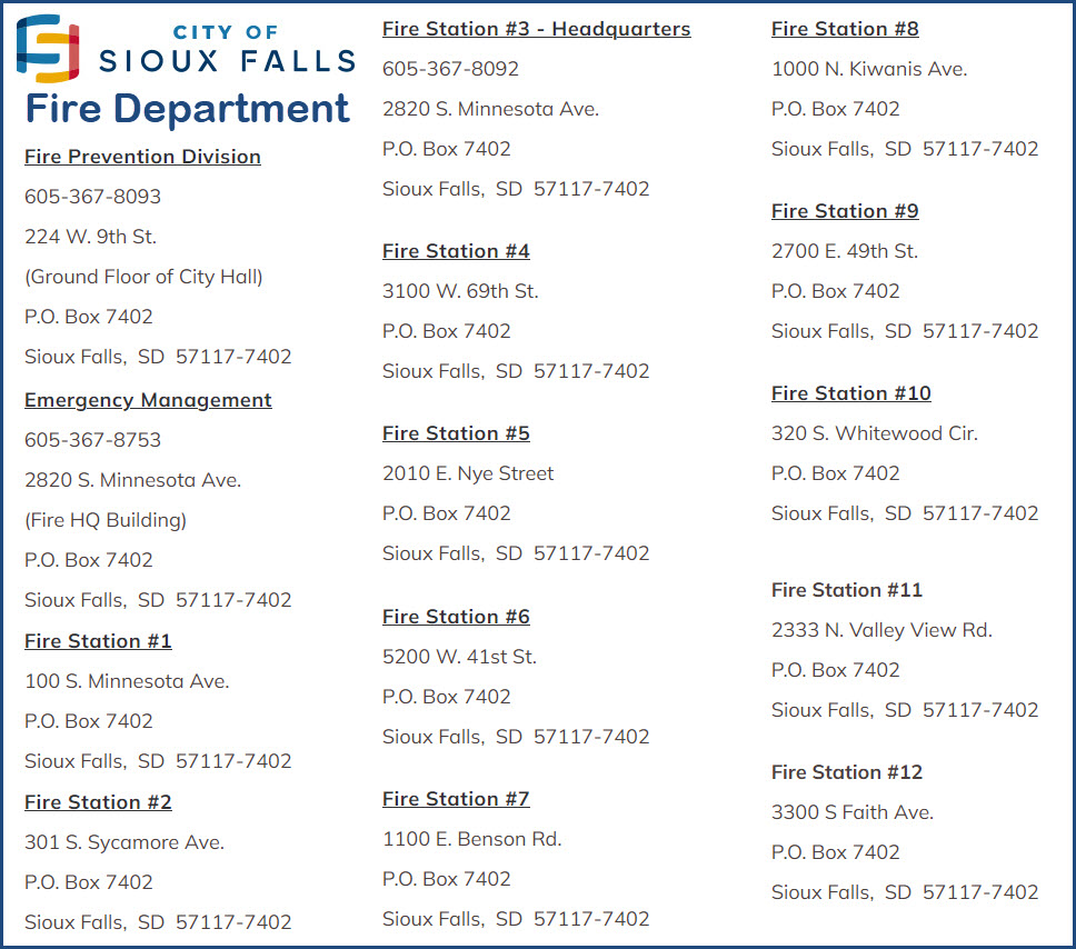
Fire & Police
Floobydust
USGS Maps
RAILROAD SIGNALS HOME
Location / Name:
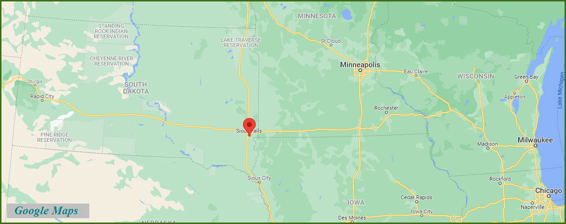
Sioux Falls SD, Minnehaha County
What's Here:
BNSF
the Ellis and Eastern Co (RR)
Former GN Depot and Freight Shed
BNSF Sioux Falls Yard
Data:
GPS Coordinates: as needed
Phone A/C: 605
ZIP: 57103
Access by train/transit:
None
The Scoop:
Excerpts from the Trains Magazine blog: Sioux Falls was once served by five different railroads: 1) the Chicago & Northwestern, 2) the Great Northern, 3) the Illinois Central, 4) the Milwaukee Road, and 5) the Rock Island. The Rock Island abandoned their operations here in the early 1950's. The Illinois Central abandoned operations here about 1972 or shortly thereafter. The Chicago and Northwestern pulled out of Sioux Falls for the last time in 1988, and the Milwaukee Road abandoned their operations here a year later. (end Trains)
A little additional history on the railroads in Sioux Falls.... As already stated, Sioux Falls was served by five railroads up until the early 1970's. The first to arrive was a predecessor of the Omaha (CNW) from Worthington (Org) MN. The first to leave was the Rock Island in 1972 when a bridge washed out by Lester IA on their branch from Ellsworth MN to Sioux Falls.
The last train to run east out of SF on the Illinois Central was in the summer of 1981. The vast majority of the IC's business from 1909 until 1969 were reefers full of swinging meat from the John Morrell packing plant. IC's branch ran from Cherokee IA to Sioux Falls thru my home town of Hills MN. I believe the MILW stopped running thru town around 1982. They operated on a branch from Canton SD to Egan SD. Up until the 1930's the MILW had a branch off the Egan line at Renner SD that ran northwest to Madison SD. The Omaha pulled out last. At one time the Omaha continued west from Sioux Falls to Mitchell. That branch was abandoned around 1977. The Illinois Central was abandoned after heavy rains washed out the trestle over the Big Sioux River. They said in the paper it wasn't worth building a new one, so the rails were pulled back all the way to Cherokee.
I worked for the Buffalo Ridge RR on the former Omaha line into SF during the summer of 1988. Shortly after I left their employ a junction was installed with the BN at Manley MN and they stopped running into Sioux Falls. The BNSF (former GN/BN) is still serving the remaining customers in town. The BNSF lies on a branch from Garretson SD that at one time ran all the way to Yankton SD. The portion south of SF was abandoned around 1976. The GN also had a branch from SF to Watertown SD. This line was cut back from Watertown shortly after the BN merger.
Today Sioux Falls is served by the BNSF, the D&I, and the E&E. The Dakota & Iowa runs rock trains over the BNSF between Dell Rapids and Sioux City IA. The Dakota, Minnesota & Eastern had trackage rights over the BNSF here. And Sioux Falls has a shortline known as the Ellis & Eastern which is owned and operated by Concrete Materials - The Ellis & Eastern runs over trackage which was originally laid by the Chicago, Rock Island & Pacific. The CNW used to service the local Concrete Materials cement plant up until 1988.
You could say that Sioux Falls is on BNSF "secondary mainline". They handle a fair amount of traffic, mostly grain, ethanol, and pink rocks passes through town, coming from somewhere else, headed to somewhere else. The BNSF lies on a branch from Garretson SD that at one time ran all the way to Yankton SD. The portion south of SF was abandoned around 1976. The GN also had a branch from SF to Watertown SD. This line was cut back from Watertown shortly after the BN merger. Today BNSF still operates what's left of it to Wentworth SD where it connects to the former MILW west to Madison. The Ellis & Eastern operated on the former Omaha line east to west thru SF. They served the SD Cement Plant terminal, a small scrap metal dealer, and a few other small business's along with their owner, Concrete Materials. Except for Concrete Materials, the BNSF now serve these business's. The E&E also has trackage rights on the BNSF to Corson SD to serve their owners gravel pit.
The main industries are medicine, banking, meat packing, and being a regional distribution center. Being a distribution center is tied to being at the crossroads of the state's only 2 interstates. With the exception of lumber, most products for trade are shipped in and out by truck.
The above info came as a response from the following question: I recently read that Sioux Falls South Dakota is the fastest growing city in the Midwestern United States with over 125,000 people. It is at the junction of I-90 and I-29 but it seems to have rather limited rail service; and is not on a transcontinental main line. How does Sioux Falls rail service impact business wishing to re-locate there. It has no corporate or state income tax, but is that enough for business to go to Sioux Falls? The general consensus was: If it's like most other cities trying to attract new business, rail service won't be high on the list. Most places want to attract white collar, professional type businesses. They want the headquarters staff, not the production facilities. Good highway access and a good airport is what they care about most.
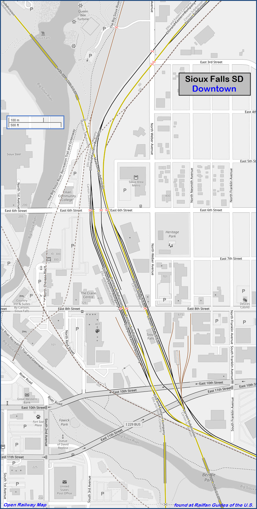
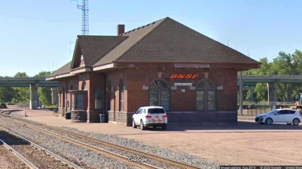
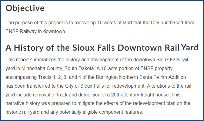
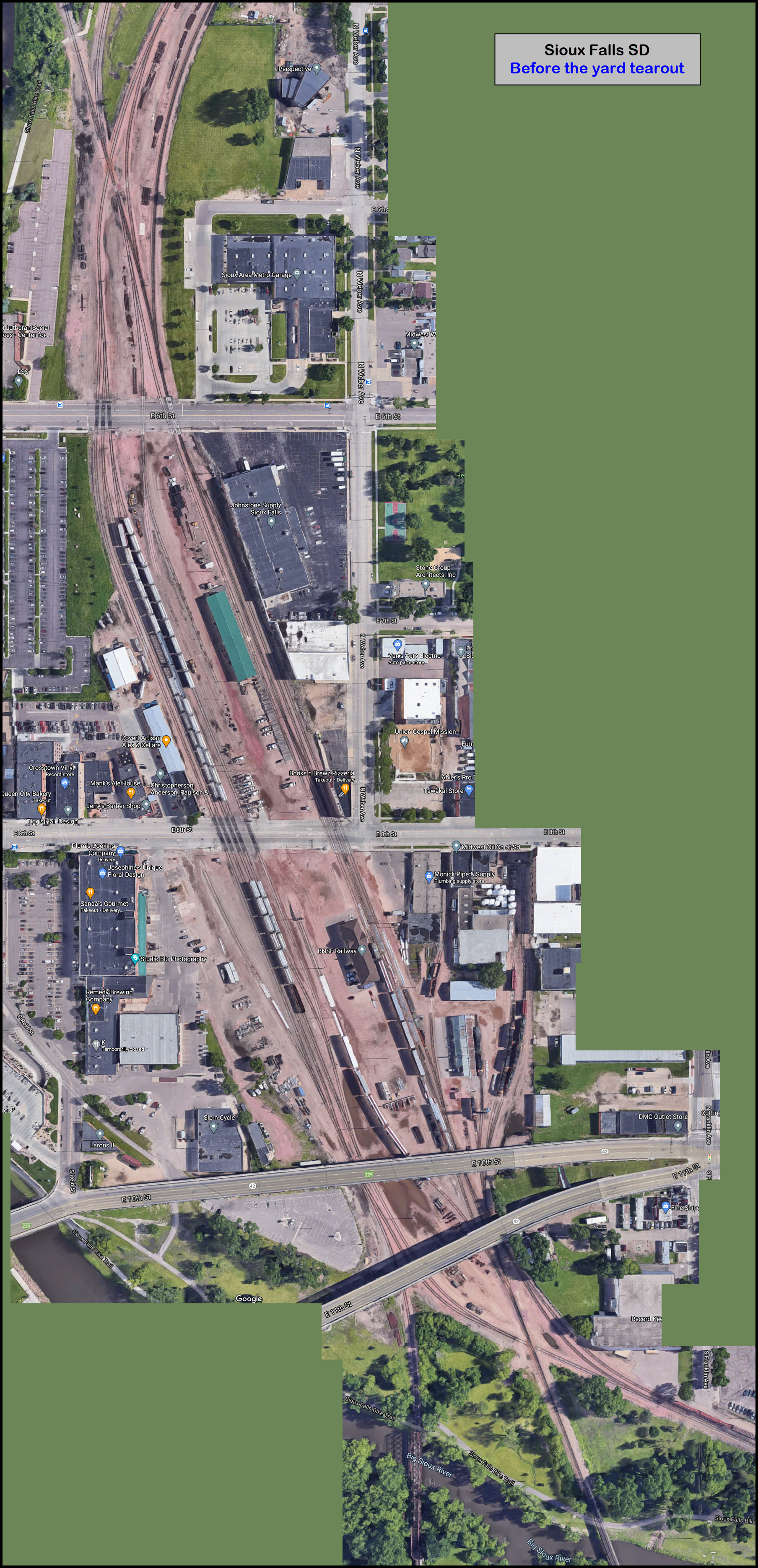
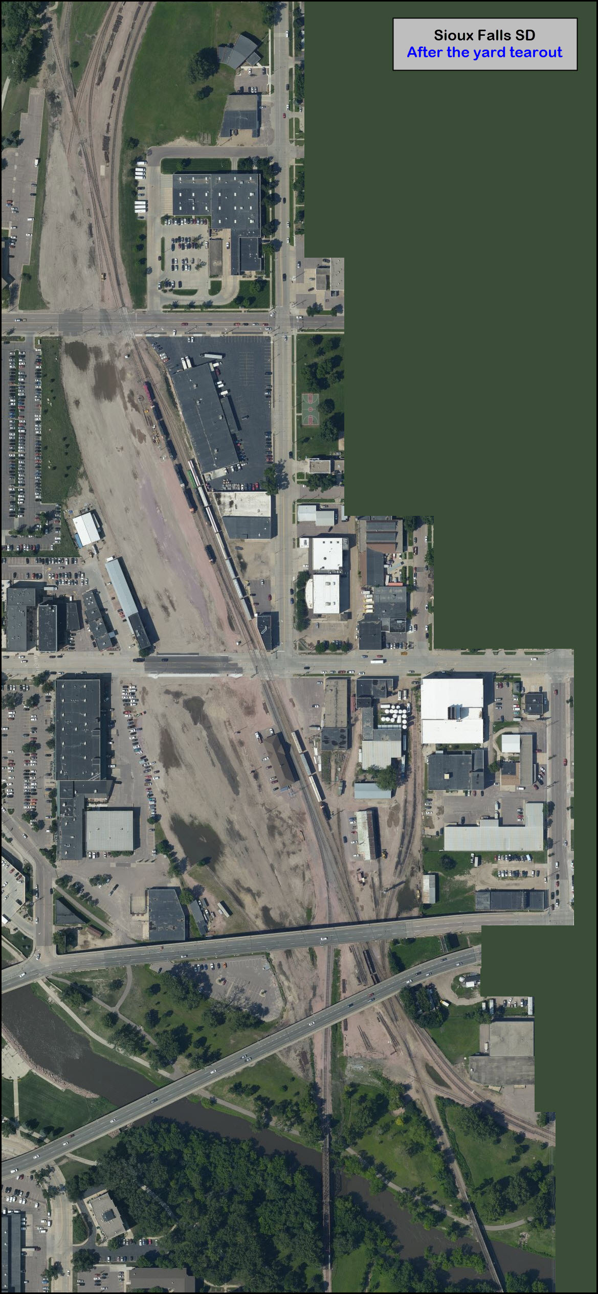
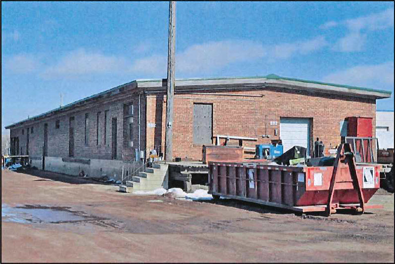
Most of the BNSF Yard in downtown has been recently taken up, in a revival project for the downtown area. In the process, a GN freight shed was torn down, but the old GN depot still stands and is used by BNSF.
Acknowledgements:
Bill Kalkman
Jerry Fisher
gopherstate
Jerry Huddleston
CanadianPacific2816, aka, RLII
Denver Todd
Wikipedia
Google Maps
Open Railway Map
Bing Maps
Websites and other additional information sources of interest for the area:
https://www.flickr.com/photos/jerry7171/38716924875/
https://www.flickr.com/photos/jerry7171/38712101902/in/dateposted-public/
https://www.flickr.com/photos/jerry7171/27561368369/in/dateposted-public/
https://www.flickr.com/photos/jerry7171/39629452801/in/dateposted-public/
https://www.siouxfalls.org/railyard
https://en.wikipedia.org/wiki/Ellis_and_Eastern_Company
https://en.wikipedia.org/wiki/List_of_South_Dakota_railroads
https://www.thedieselshop.us/EllisEastern.HTML
http://johnmarvigbridges.org/Brandon%20Rail%20Bridge.html
http://cs.trains.com/trn/f/111/t/169406.aspx
https://www.svmes.net/
https://www.siouxlandmuseums.com/home-page/old-courthouse-museum-exhibits-2/previous-exhibits/a-city-on-track-sioux-falls-the-railroads/
https://history.sd.gov/preservation/docs/SDRailroad.pdf
https://akronrrclub.wordpress.com/tag/dakota-iowa-railroad/
https://bridgehunter.com/category/railroad/dakota-iowa-railroad/
https://www.pletsexpress.com/fnimall/Plets/070DAIR/vid_trains.phtml
https://iowadot.gov/iowarail/pdfs/diar.pdf
Sioux Falls is conveniently located at the junction of I-90 and I-29, at the far east end of the state. It is about 260 miles SW of Minneapolis via I-35 and I-90. It is about 490 west of Milwaukee via I-90 and I-94, add another 60 miles to get to Chicago.
There are two exits off of I-90, at exit 395, North Marion Rd (where a Super-Walmart is located), and exit 399, Cliff Rd. You head south into town from these two exits.
From I-29, which is x396 off of I-90), there are 3 exits: x83 (W 60th St N), x82 (Benson Rd), x81 (Maple/Russell St), x79 (12th St), x78 (Louise Ave/W 26th St), x77 (W 41st St), and x75 (the south end of I-229). Of these, 12th St is the best bet for getting downtown to the yard area, head east off the interstate about 3 miles.
From I-229, the easiest exit to get to downtown is x6, E 10th St. Head west 1.2 miles.
If you're coming up from the south, I would take I-229 at the split, and take the East 10th St exit, it is quicker.
GPS Coordinates: 43.547920, -96.719995
503 E 8th St, Sioux Falls, SD 57103
It's now the local office for the BNSF, and was spared being torn down for the downtown revival.
Not sure when they ripped it up, but most of it is gone, and the streets have been repaved where they tore up the tracks.
1201 Russell St, Sioux Falls SD 57104
Phone: 605-357-6075
The Ellis and Eastern RR (reporting mark EE) is a railroad owned and operated by Sweetman Construction Company.
Operating on former Chicago and Northwestern (CNW) trackage, it was formed to ship Sioux Quartzite and other materials such as sand and gravel from a large quarry in Sioux Falls SD, for Sweetman Construction Company, which uses the railroad primarily to ship materials from the quarry it operates to a concrete plant nearby. Over time, the Ellis and Eastern has shipped more diverse products such as lumber, chemicals, machinery, scrapmetals, and grain to other customers.


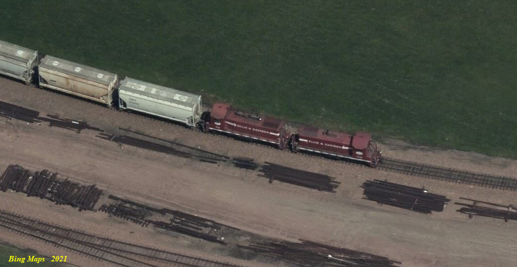
Google captured one of their engines at the concrete plant....
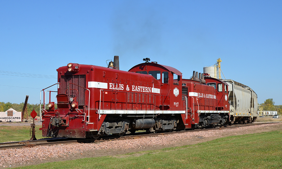 2013, Bill Kalkman
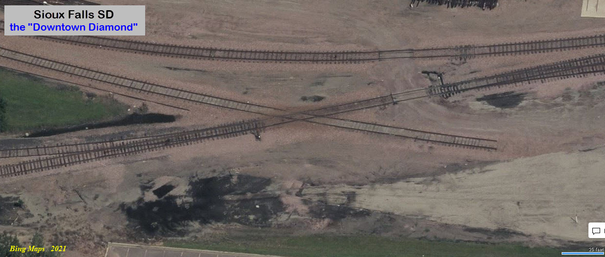
The screen shot below is taken from Bing Maps Birds Eye View from 11/2021, near where the downtown diamond used to be... dunno how long it will be there :-)
350 S Main Ave Suite 400, Sioux Falls SD 57104 (Office building in the middle of town, not near tracks)
Phone: 605-334-5000
From Wikipedia: The D&I Railroad (DAIR) (also nicknamed the Dakota and Iowa Railroad) is a Class III shortline railroad which is a wholly owned subsidiary of L. G. Everist, Inc. The line hauls ethanol, dried distillers grains (DDG), corn oil, plastic pellets, cement, sand, gravel, and Sioux Quartzite, which is mined from two large quarries in Dell Rapids. The D&I has a trackage rights agreement with BNSF that allows it to travel on three BNSF subdivisions to deliver and sell products, as they must use BNSF’s system to reach their southern half of their trackage. The D&I operates on both former Chicago, Milwakuee, St. Paul and Pacific Railroad and Chicago and Northwestern RR trackage, which were handed over to the state of South Dakota in 1980-1981 after the Milwaukee Road’s bankruptcy and subsequent abandonment of unprofitable lines. end Wiki
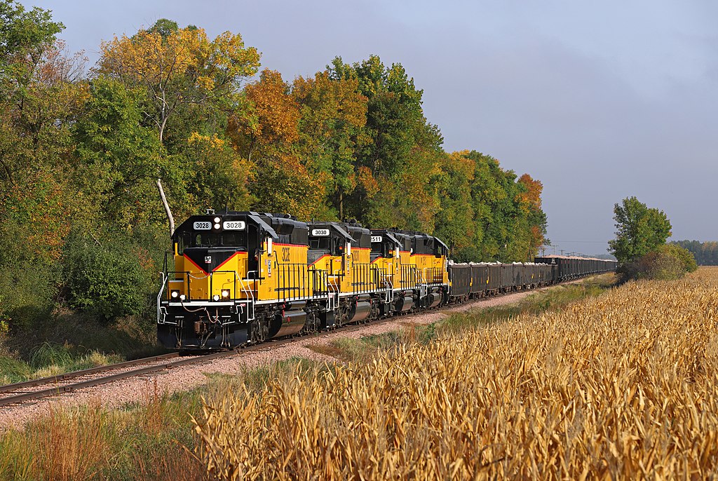 photo: Jerry Huddleston via Wikipedia
Now gone to make room for the downtown revival, but is included for historic purposes.
The next four pictures come from Jerry Fisher, and were taken in December 2017. He painfully stitched together a whole slew of pictures in order to give you the finished product, which does a great job of imparting the presence of this building.

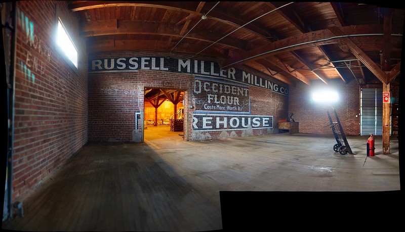
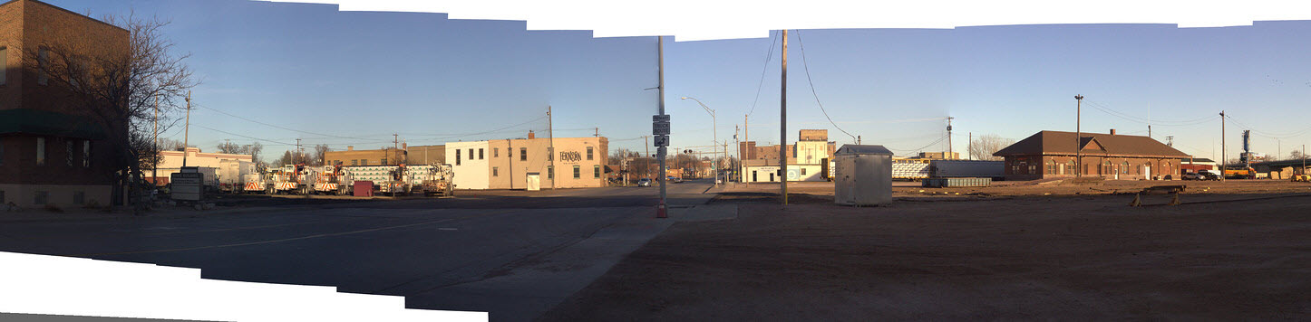
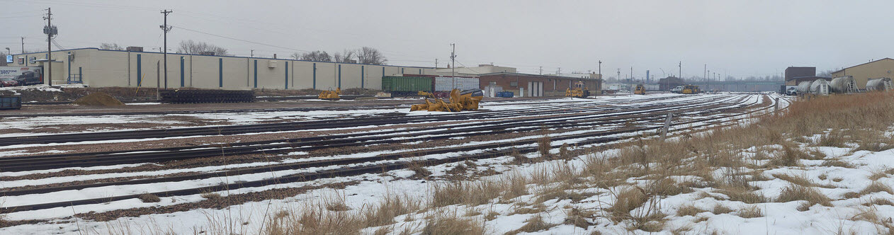
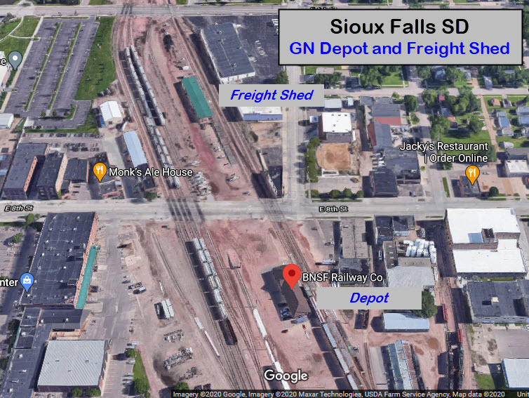


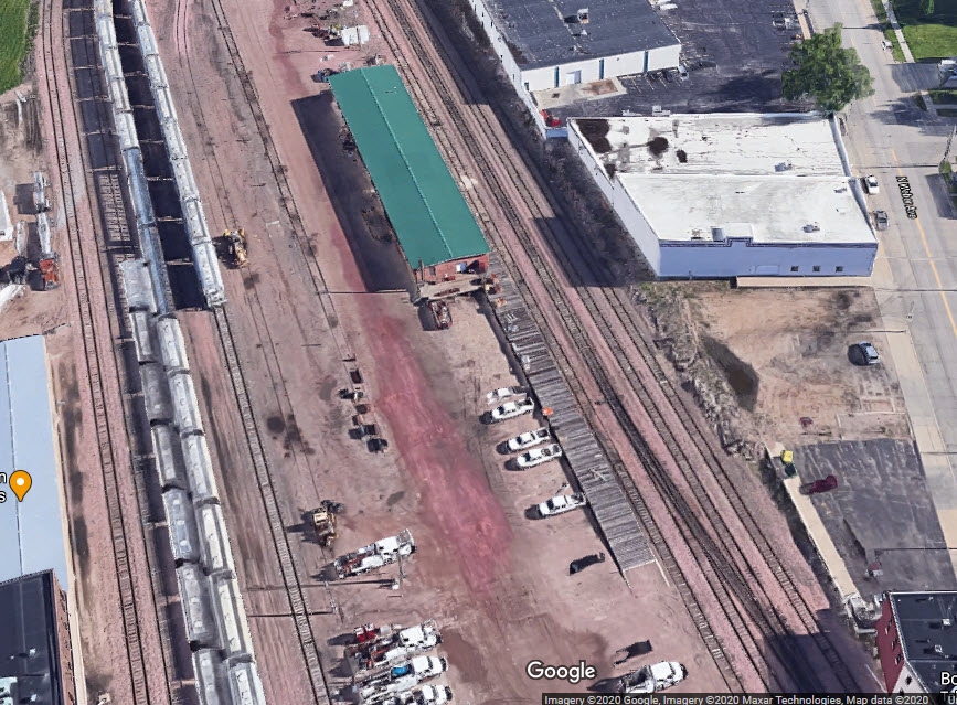
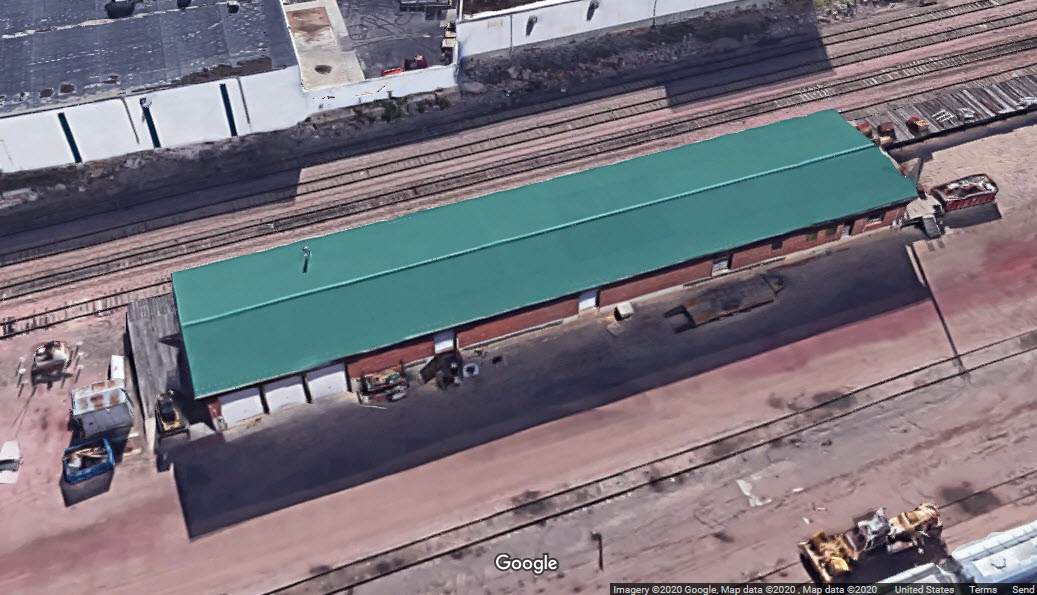

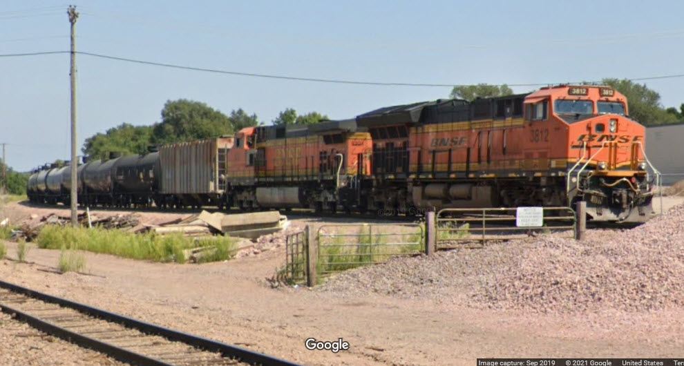
 photo by Jerry Huddleston
 photo by wsor_3807
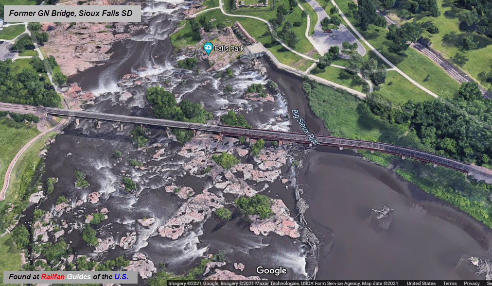
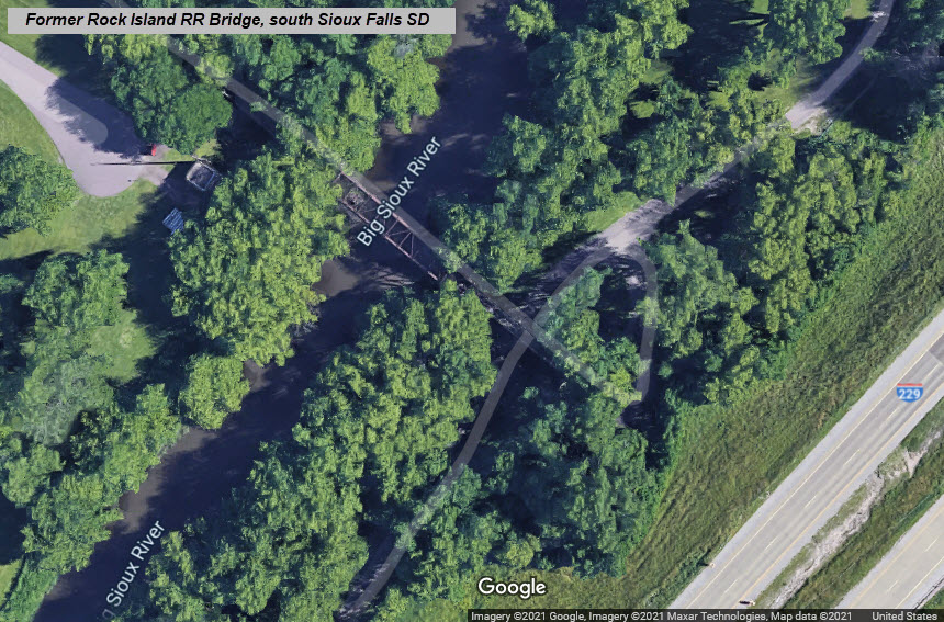
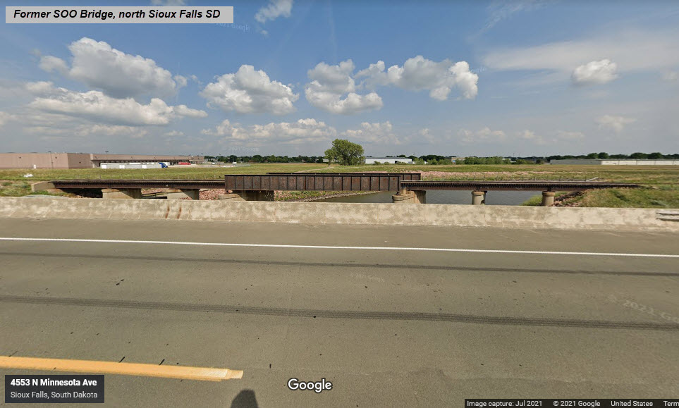
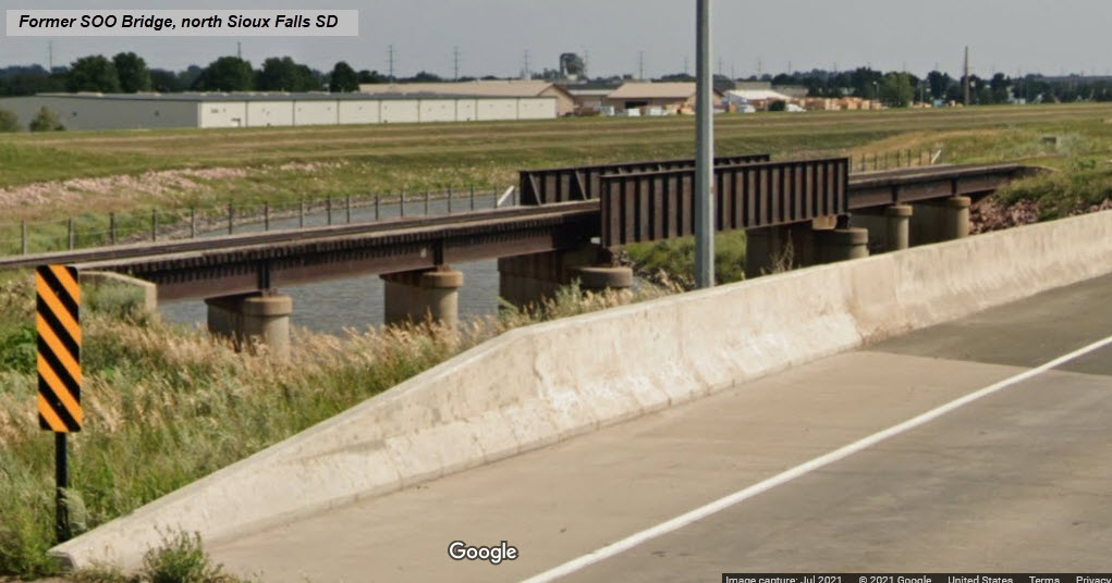
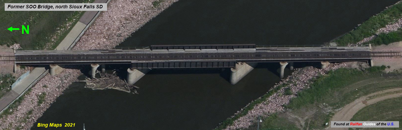
As best I can tell, there are/were six railroad bridges used to cross the Big Sioux River flowing thru town, a seventh took the SOO Line over the canal NW of town.
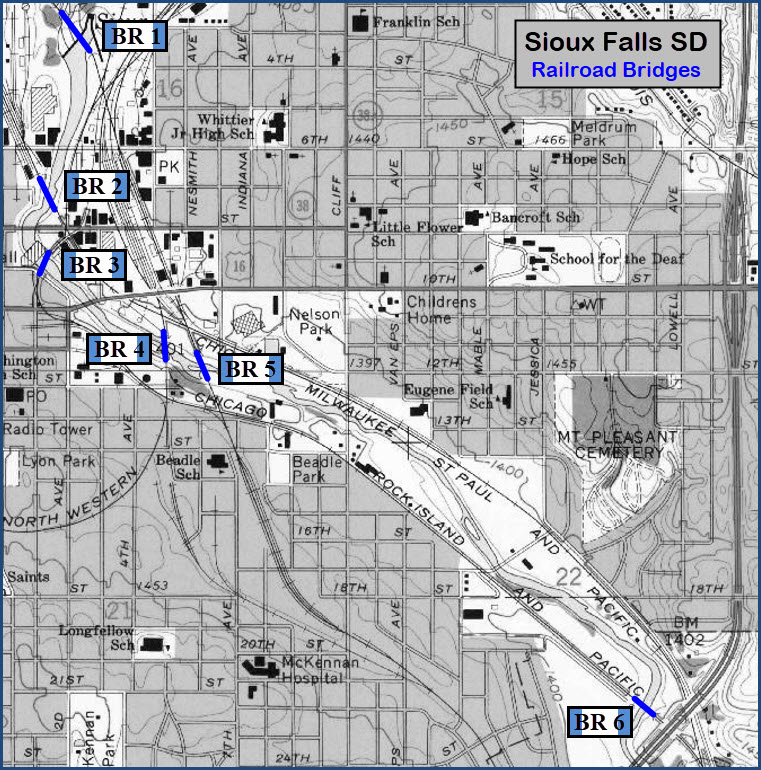
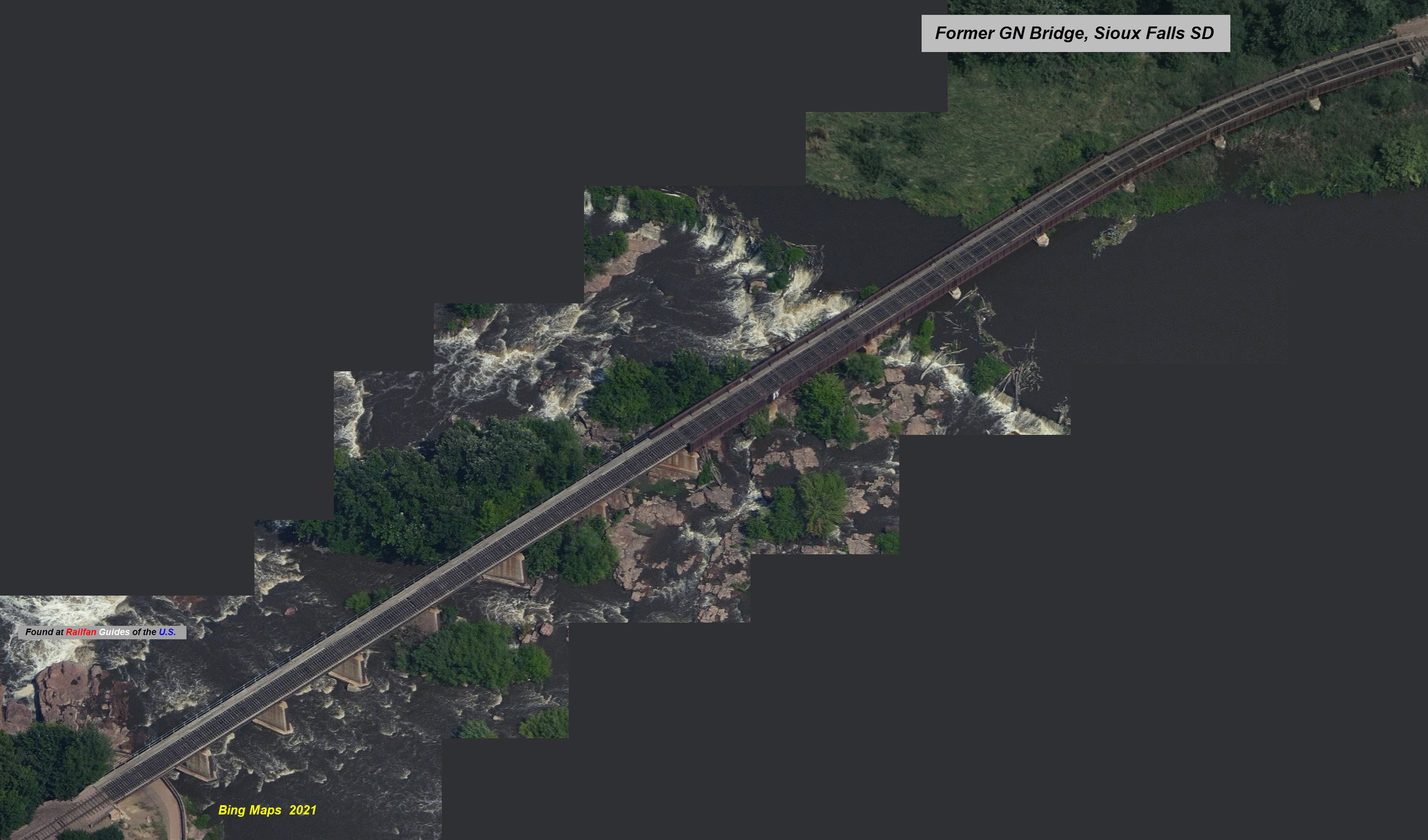
GPS Coordinates: 43.55490 , -96.72334 (center of bridge)
A 15 section girder bridge, the southern half is comprised of 8 steel thru girder sections, and the northern half is 7 sections of (maybe) steel deck girder type. A quick rundown on railroad bridge types is here.
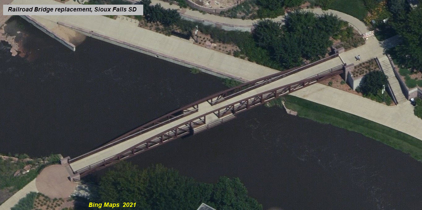
GPS Coordinates: 43.54968 , -96.72472
This bridge has been replaced by a modern design and forms part of the river walkway/bike trail system.
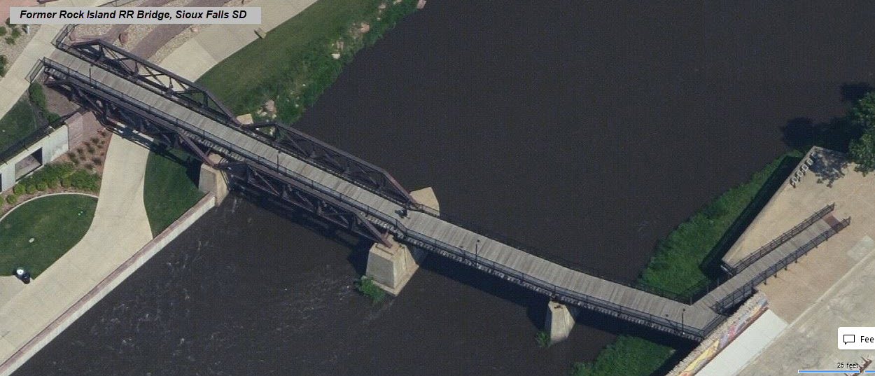
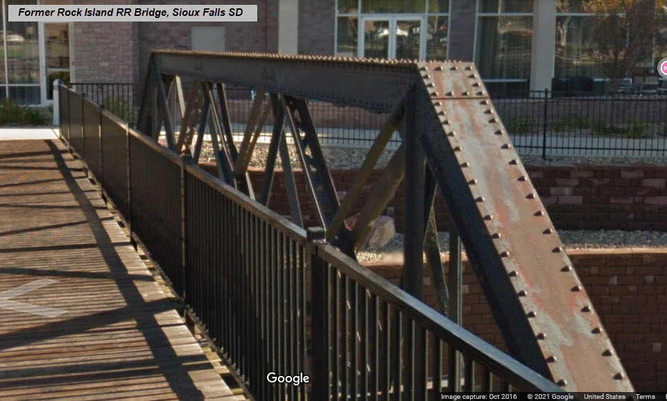
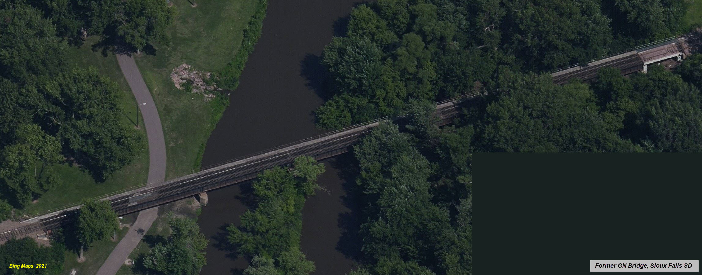
GPS Coordinates: 43.54748, -96.72489
This bridge, which has 2 trestle spans and 2 steel deck girder spans on original concrete pilings, has been repurposed as part of the river walkway/bike trail system.

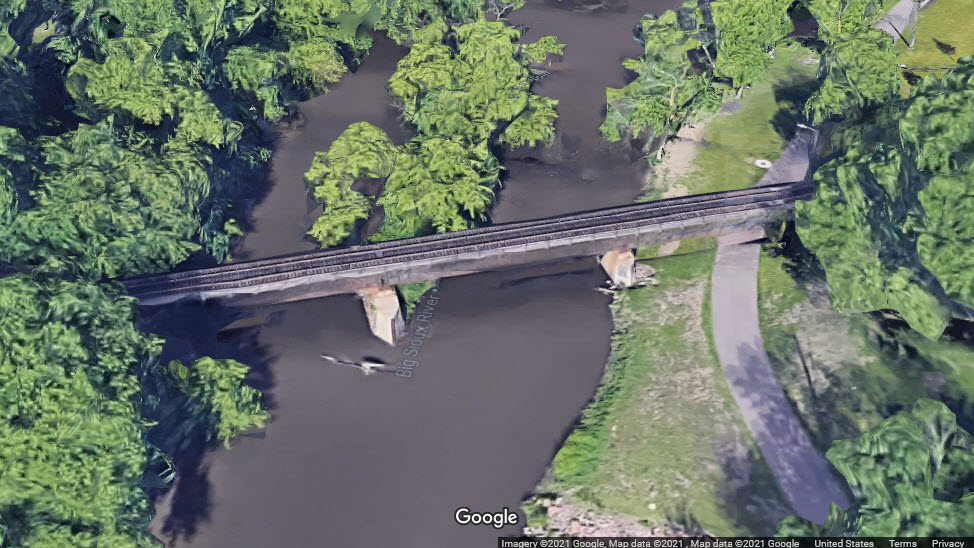
GPS Coordinates: 43.54475, -96.71950
This bridge is a single track trestle with 2 spans.

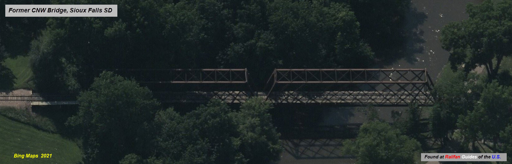
GPS Coordinates: 43.54404, -96.71773
Girder bridge for a single track, still in use.
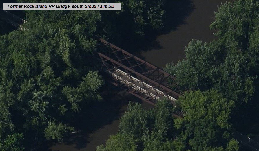
GPS Coordinates: 43.53307, -96.69817
This bridge is no longer in service, and there is no track in the area - it has been repurposed as part of the river walkway/bike trail system around Sioux Falls.
GPS Coordinates: 43.59631, -96.72823
A single track, single span steel thru girder bridge with a steel deck girder approach on both sides, going over the canal and the Sioux Falls Bike Trail.
I'm not seeing any signals, at least in town..... Is anyone aware of any I missed?
GPS Coordinates: 43.54706, -96.73093
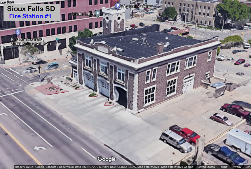
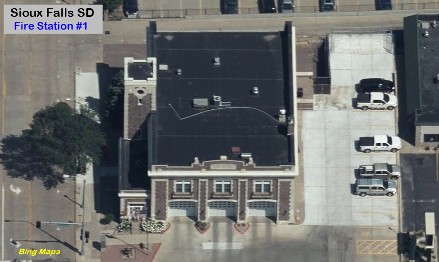
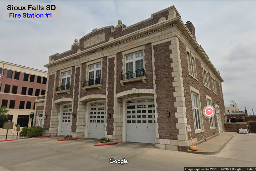
100 South Minnesota Ave, Sioux Falls SD, 57117-7402
The police department does not have a table of locations like the fire department has.
GPS Coordinates: 43.55442, -96.73042
320 W 4th St, Sioux Falls SD 57104


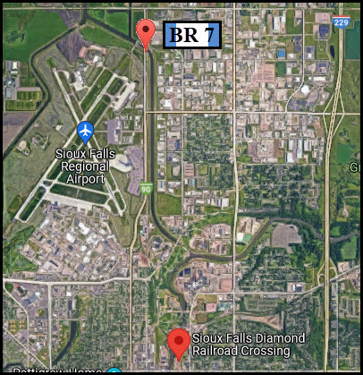
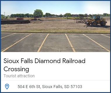
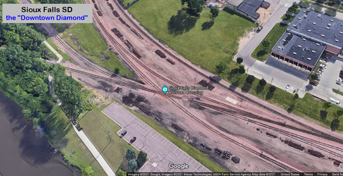
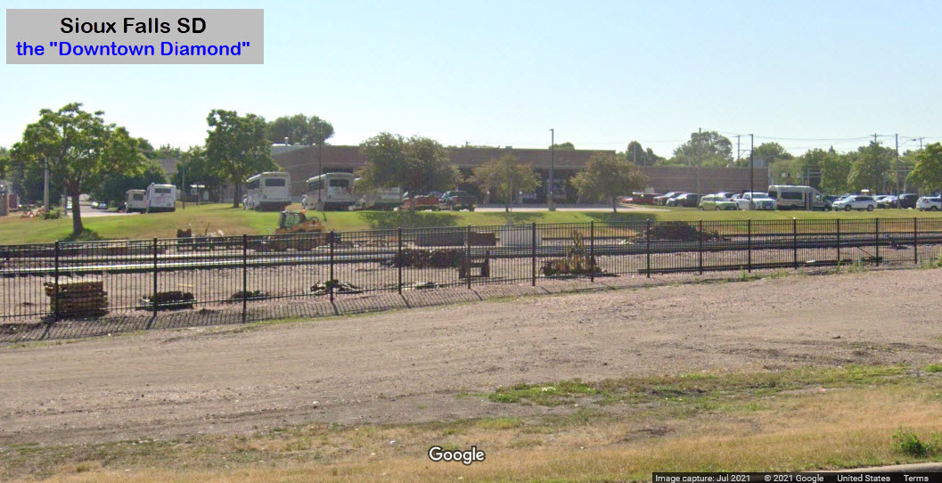
the Downtown Diamond
Now that most of the yard is gone, there is no need for this diamond to exist, so if it is not already gone, it probably will be soon. The third screenshot may even be showing us that the diamond has been removed, can't quite tell. For now, Google has is as a tourist location.

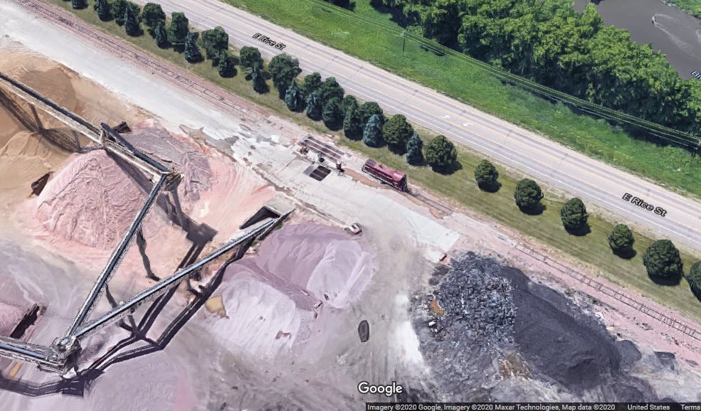
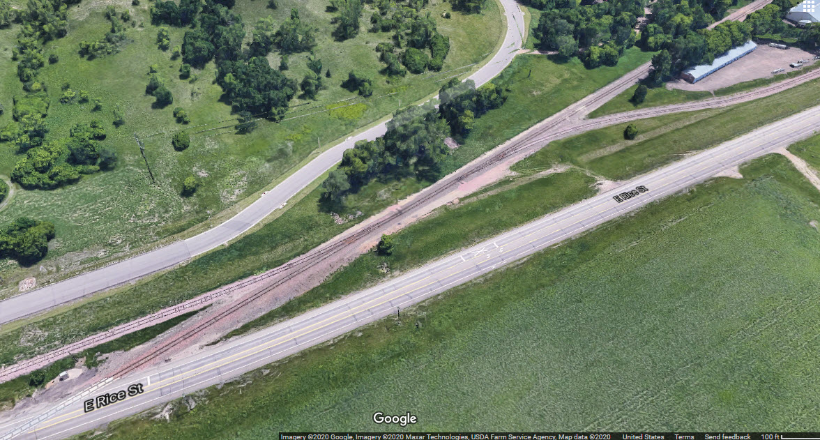
Rice Street Diamond
Now gone, but you can see where it used to be....

Disclaimers:
I love trains, and I love signals. I am not an expert. My webpages reflect what I find on the topic of the page. This is something I have fun with while trying to help others.
Please Note: Since the main focus of my two websites is railroad signals, the railfan guides are oriented towards the signal fan being able to locate them. For those of you into the modeling aspect of our hobby, my indexa page has a list of almost everything railroad oriented I can think of to provide you with at least a few pictures to help you detail your pike.
If this is a railfan page, every effort has been made to make sure that the information contained on this map and in this railfan guide is correct. Once in a while, an error may creep in :-)
My philosophy: Pictures and maps are worth a thousand words, especially for railfanning. Text descriptions only get you so far, especially if you get lost or disoriented. Take along good maps.... a GPS is OK to get somewhere, but maps are still better if you get lost! I belong to AAA, which allows you to get local maps for free when you visit the local branches. ADC puts out a nice series of county maps for the Washington DC area, but their state maps do not have the railroads on them. If you can find em, I like the National Geographic map book of the U.S..... good, clear, and concise graphics, and they do a really good job of showing you where tourist type attractions are, although they too lack the railroads. Other notes about specific areas will show up on that page if known.
Aerial shots were taken from either Google or Bing Maps as noted. Screen captures are made with Snagit, a Techsmith product... a great tool if you have never used it!
By the way, floobydust is a term I picked up 30-40 years ago from a National Semiconductor data book, and means miscellaneous and/or other stuff.
Pictures and additional information is always needed if anyone feels inclined to take 'em, send 'em, and share 'em, or if you have something to add or correct.... credit is always given! Please be NICE!!! Contact info is here
Beware: If used as a source, ANYTHING from Wikipedia must be treated as being possibly inaccurate, wrong, or not true.
RAILFAN GUIDES HOME
RAILROAD SIGNALS HOME
NEW 10/17/2020, NOV04/05/06/07/2021
Last Modified 08-Nov-2021