In General
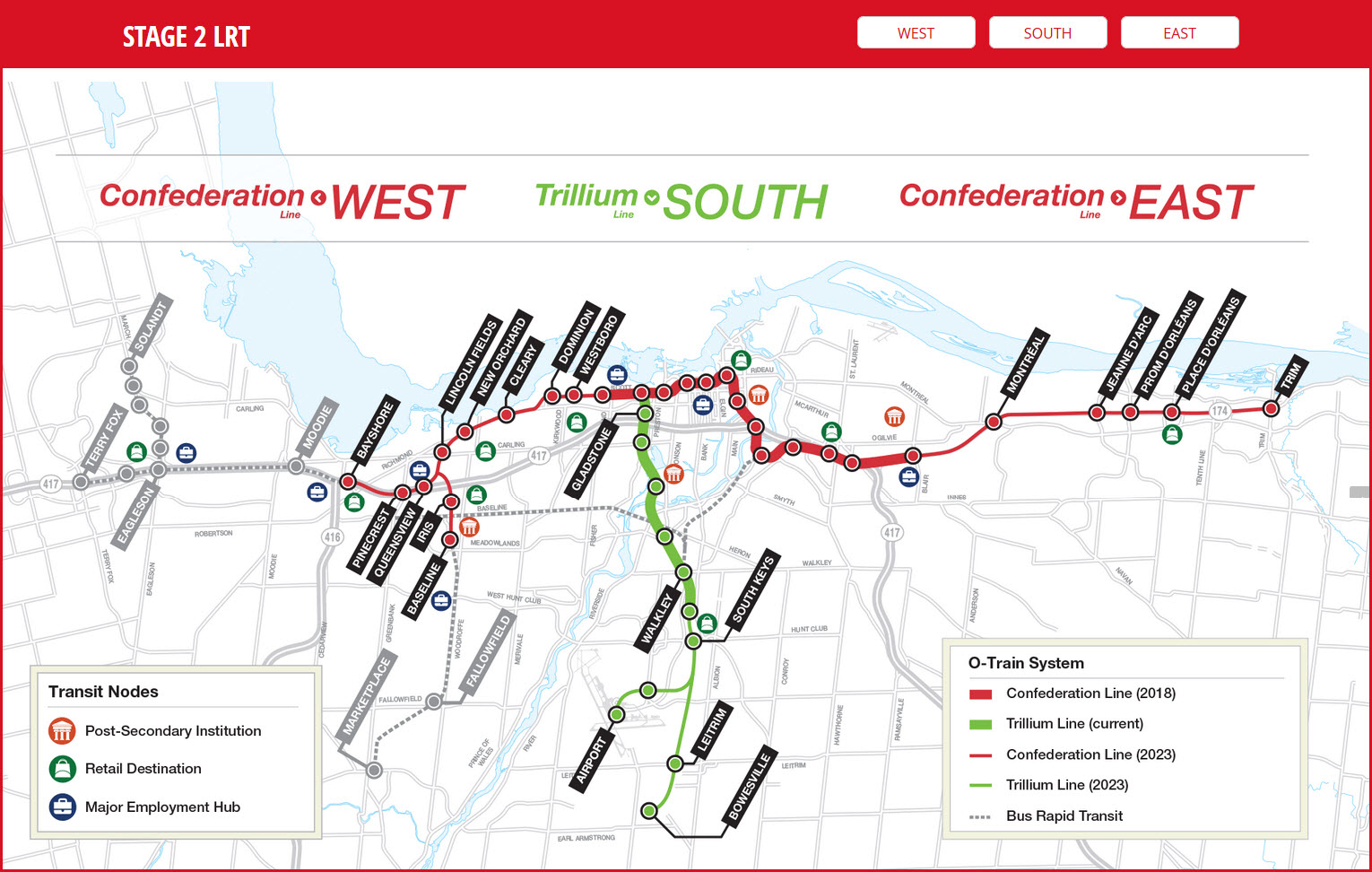
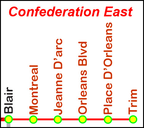
Map
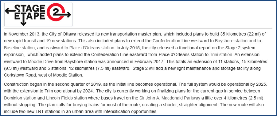
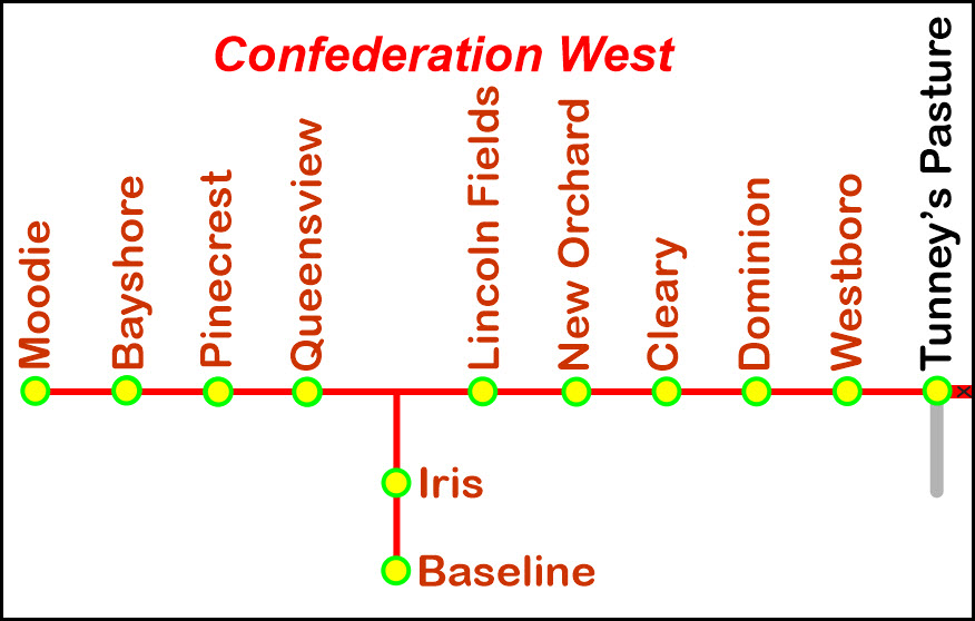
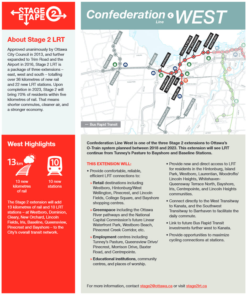
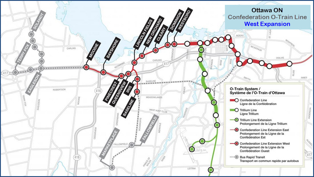
Phase 2 Extension West
Phase 2 Extension East
Floobydust
RAILROAD SIGNALS HOME
Location / Name:
Ottawa ON Canada
What's Here:
new Light Rail System, to be opened in 2020?
the O-Train Trillium Line (the original O-Train)
Data:
GPS Coordinates: 45.408926, -75.721703 (Bayview station)
ZIP/Postal code: K1R 1C7
Area code: 613
Access by train/transit:
Via service at the Tremblay station
Via service 5.55km (3.43 miles) from Bayview station
O-Train Trillium Line Service at the Bayview station
The Scoop:
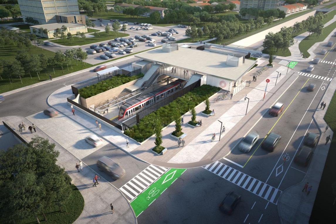
This page covers the projected expansion to the Confederation Light Rail line in Ottawa. I used to have this info on the main page for the COnfederation line, but all of it on one page made the page "too big". Pictures of the stations used below are artists rendering that came from ottawa.ca's website.
From Wikipedia: The Confederation Line, also called O-Train Line 1, is a light rail line operated by OC Transpo in Ottawa ON, as part of the city's O-Train light rail system. The Confederation Line opened on September 14, 2019 - it is the second O-Train line to be opened. It operates on an east to west route to complement the north to south Trillium Line (which is the original, or first O-Train line). At a cost of just over $2.1 billion, it was the largest infrastructure project awarded in the history of the city before being surpassed by the Stage 2 extension of the line which will cost $4.66 billion.
A good majority of the Confederation Line AND its extensions is built on what used to be a bus Transitway, so most of the road/highway is either gone, or has been moved. Personally, I think they should have made the Confederation right-of-way a dual purpose line, so busses could still use the route, thereby making better use of the land - they should have just run a track down the existing transitway highway :-) If you look at Bing's map before it gets updated, you can still see the Transitway as it used to exist.
Projected Stage 2 construction is detailed below:
Acknowledgements:
Wikipedia
Trains Magazine
Open Railway Map
Bing Maps
Websites and other additional information sources of interest for the area:
https://en.wikipedia.org/wiki/Confederation_Line
http://www.ligneconfederationline.ca/page/4/ construction info
http://www.stage2lrt.ca/ stage 2 info pages
https://ottawa.ca/en/planning-development-and-construction/major-projects/stage-2-light-rail-transit-project/confederation-line-west-extension
Map
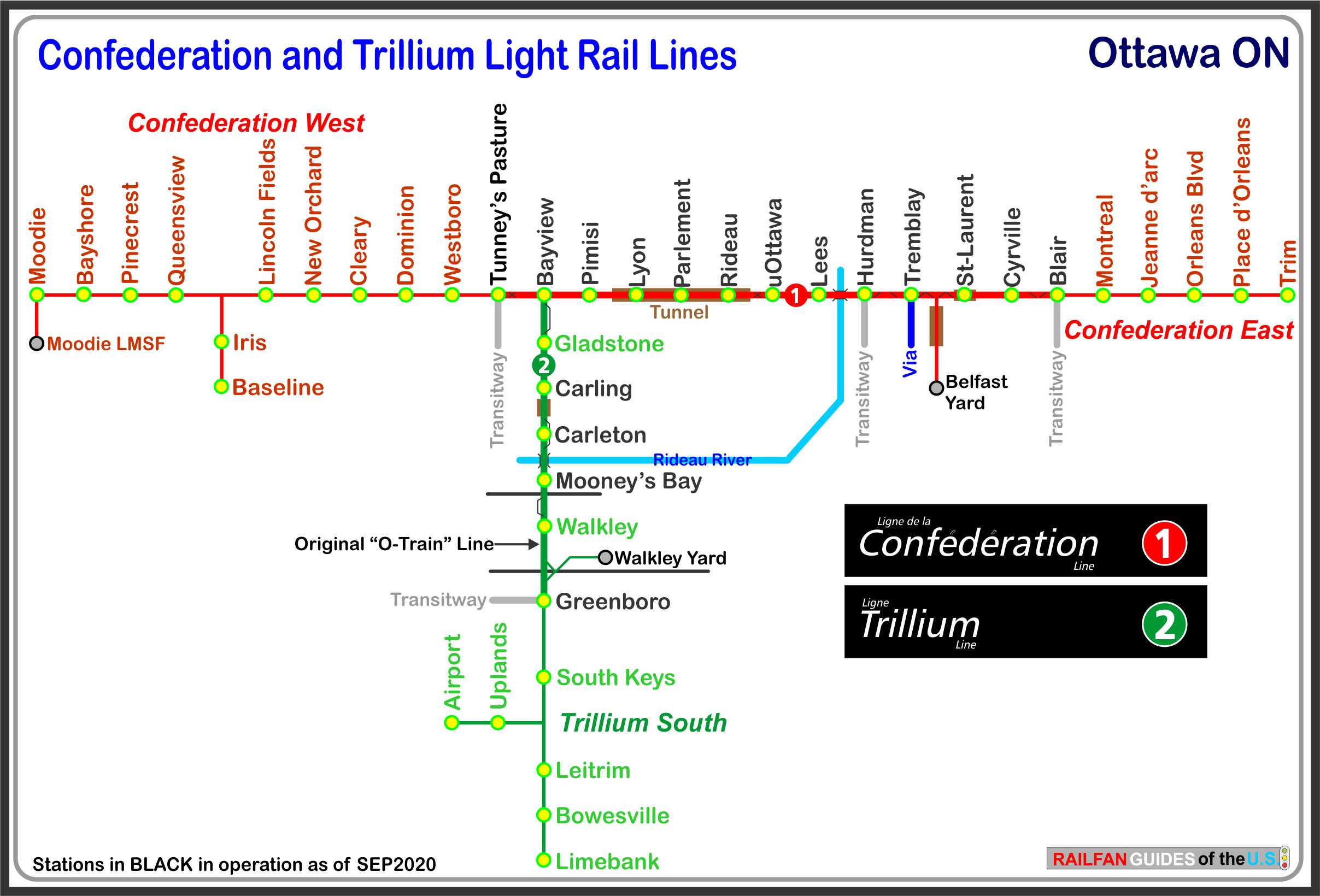
I hope the above map is correct, because there are oodles of maps out there,
and few agree with each other....
Proposed Phase 2 Extension West
Overview
The Confederation Line West is one of the three major extensions to Ottawa’s light rail transit system. This extension will see LRT continue from Tunney’s Pasture to Moodie and Baseline Stations. Revenue service for this extension is planned for 2025.
Extension Highlights
15 kilometres of rail and 11 new stations. New connections to light rail transit for the communities of Hintonburg, Island Park, Westboro, Laurentian, Woodroffe North, Woodpark, Lincoln Heights, Whitehaven, Queensway Terrace North, Bayshore, Iris, Centrepointe and Lincoln Heights. Connect to greenspace including the Ottawa River pathway and the National Capital Commission’s future Linear Waterfront Park, Westboro Beach, and Pinecrest Creek Corridor.
Extension Description
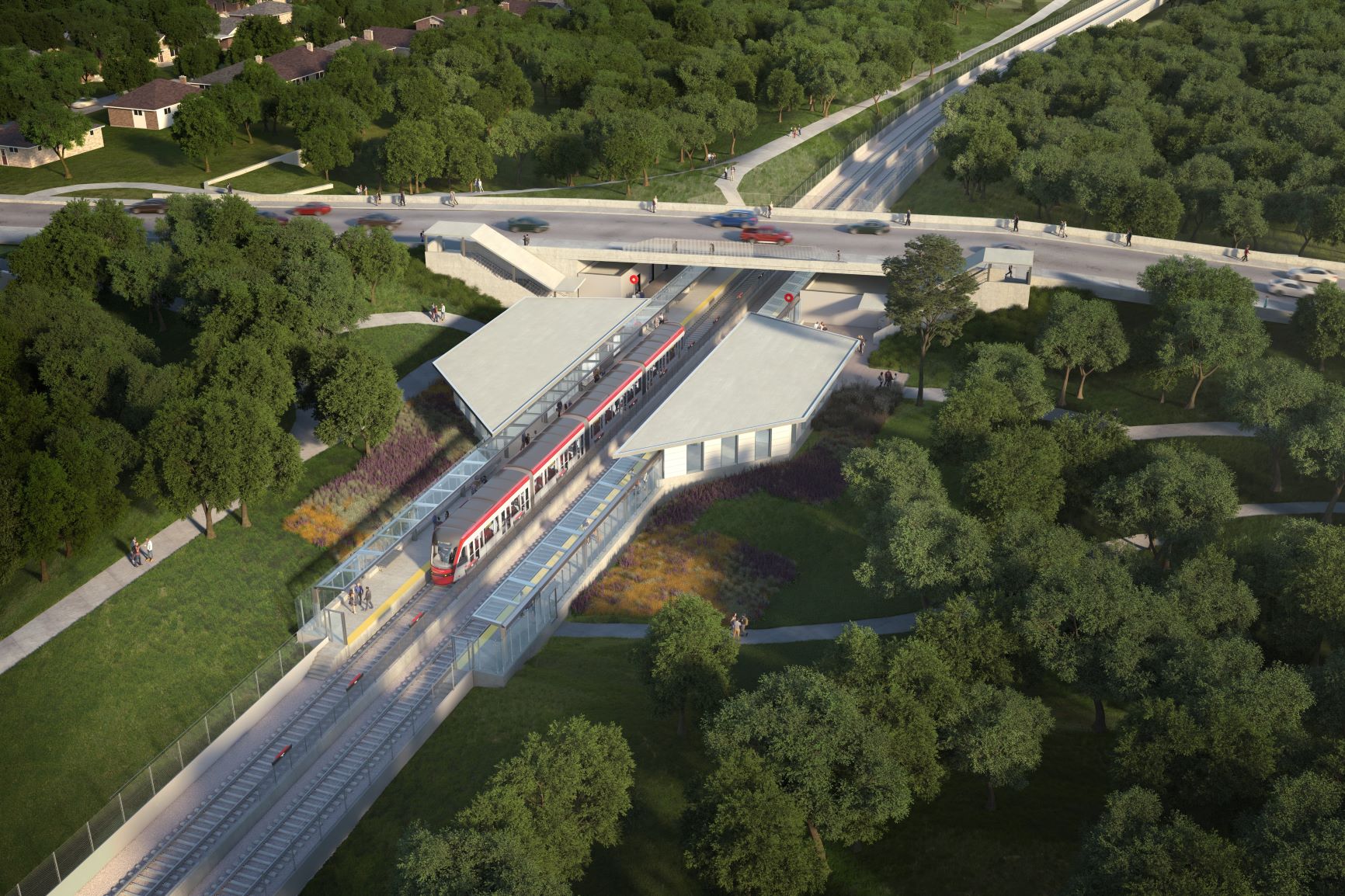
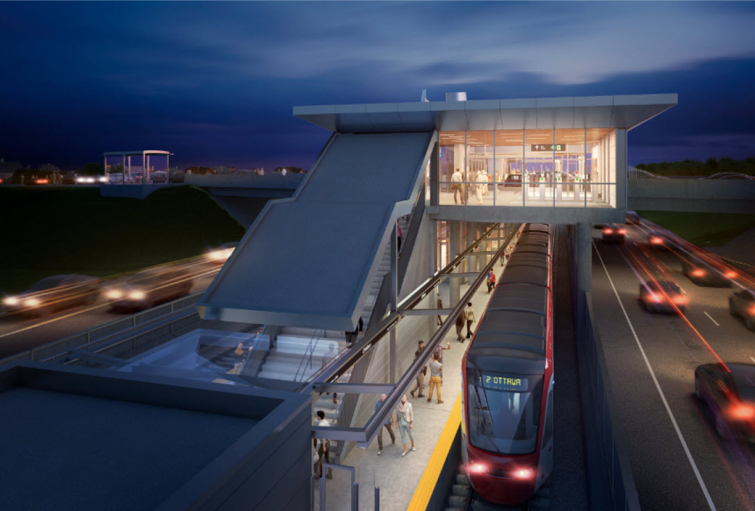
The Confederation Line West extension project will add 15 km of rail and 11 new or converted rapid transit stations to the City’s overall light rail transit (LRT) network at Moodie, Bayshore, Pinecrest, Queensview, Baseline, Iris, Lincoln Fields, New Orchard, Cleary, Dominion and Westboro. At Moodie, the Confederation Line West LRT extension will connect directly to the West Transitway to Kanata, and the Southwest Transitway to Barrhaven facilitating easy transfers to and from the Transitway. Moving east from Bayshore, the line continues along the existing bus rapid transit (BRT) corridor to a converted Pinecrest Station, then to a new station at Queensview Drive. It then runs, at grade, parallel to the north side of Highway 417 before entering into a underground covered trench beneath Connaught Avenue and then crossing above Pinecrest Creek. At Pinecrest Junction, the alignment splits, with one branch continuing via the Pinecrest Creek corridor along the existing Southwest Transitway through Iris Station and terminating at Baseline Station. The other branch continues north and then east along Confederation Line, passing through Lincoln Fields Station before entering an underground covered trench. The New Orchard Station will be located under a small section of the Byron Linear Park. East of Woodroffe Avenue, the line will run beneath the Richmond Road corridor, following the road alignment to the new Cleary Station also located under a small section of Byron Park. It will continue beneath the John A. Macdonald Parkway, emerging from the underground covered trench before reaching Dominion Station on the existing Transitway. Continuing east along the Transitway trench, the line will reach Westboro Station just north of Scott Street, and finally meet with the first-stage Confederation Line at Tunney’s Pasture Station.
Information in this section comes from ottawa.ca's website.
Westboro
Westboro Station is an existing Transitway station to the north of Scott Street between Tweedsmuir Avenue and Athlone Avenue. The Transitway will be converted to accommodate LRT. The new main entrance will be located on Scott Street and an entrance on the north side of the existing Transitway trench will facilitate the non-fare paid transfer of passengers from the bus drop off area on the existing western bus access drive. From there, passengers will connect to the LRT platform below through fare gates.
Dominion
Dominion Station is an existing Transitway Station, which will be located within the existing Transitway trench between Dominion Avenue and Berkley Avenue. Bicycle parking will be provided in the station’s public entrance plaza, which is designed to provide public access across the guideway linking pedestrians and cyclists from Dominion Avenue to Workman Avenue with direct connection to the NCC pathway on the Sir John A. Macdonald Parkway. The pedestrian bridge east of the station near Roosevelt Avenue will be decommissioned throughout construction.
Cleary
Cleary Station is a new station. The single station entrance will be located within the Byron Linear Park between Cleary Avenue and Sherbourne Road.
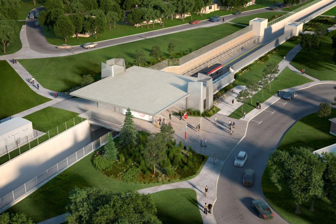
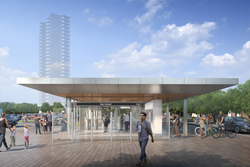
New Orchard
New Orchard Station is a new station located within the Byron Linear Park, immediately east of New Orchard Avenue. All station facilities and system support spaces will be completely below grade except for the fare paid entrance and emergency exits. New Orchard will also be constructed as an open station and the platforms will be located below the level of the existing grade.
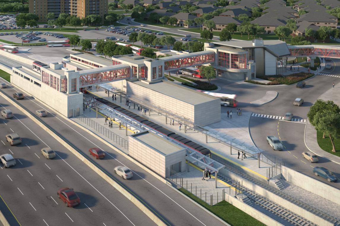
Lincoln Fields
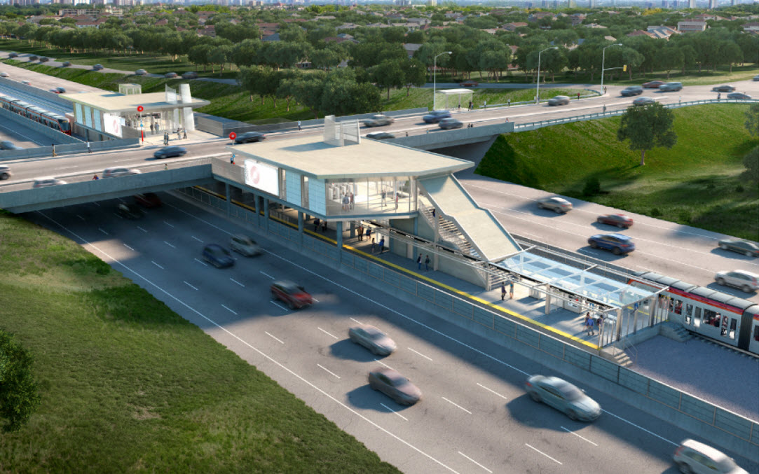
Lincoln Fields Station is an existing Transitway Station that will be re-oriented and completely rebuilt to function as a new LRT station. The train platform will be located under Carling Avenue with a fare paid connection to the bus facility to allow passengers to transfer seamlessly without a requirement to pass through fare gates or revalidate their fare. There will be a minimum of three fare-controlled entrances: a station entrance will be provided from Carling Avenue; an entrance will provide access from the west side of the Guideway at grade; and, an entrance will be provided at the bus loop. The existing bus terminal will be reconfigured to accommodate bus platforms and bus layby facilities only, and a new bus drivers’ facility. The PPUDO spaces currently located within the operating area of the bus terminal will be relocated and segregated from the fare paid zone with access from Carling Avenue, shared with buses as currently configured. This major transfer station will be outfitted with public washrooms available to fare paid customers during LRT operation hours and will have provisions for a future retail space. A signalized pedestrian crossing will also be provided to facilitate improved station access across Carling Avenue.

The line splits here to the west of Lincoln Fields. The Iris and Baseline stations are on the south leg; the Queensview, Pinecrest, Bayshore, and Moodie stations are on the western leg.
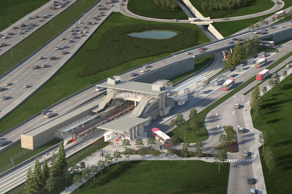
Iris
Iris Station, currently a bus stop located at the intersection of Iris Street and the existing Transitway, Iris Station will be converted to a light rail station. The station platform will be located below the level of Iris Street. The station will include vertical circulation elements for passengers to access the station from the sidewalk and bus stops located on Iris Street. Station entrance plazas on the east and west side of the guideway will be provided to safely accommodate both pedestrian and cycling traffic.
Baseline
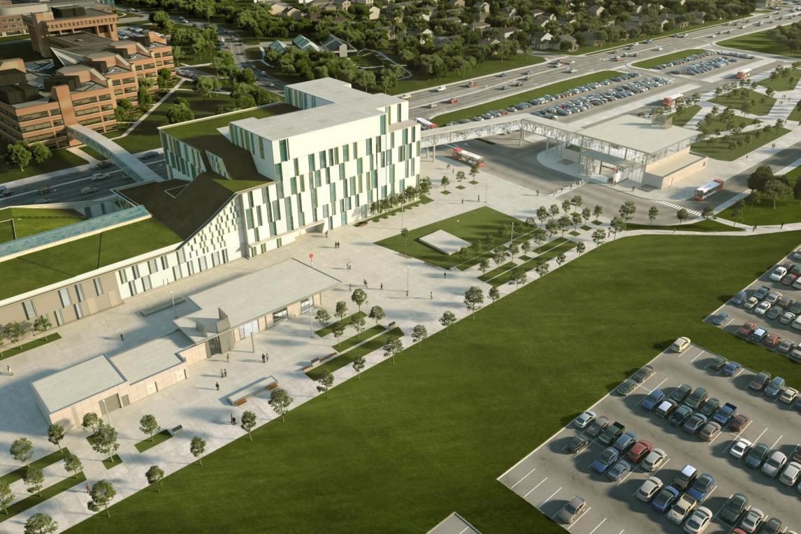
Baseline Station is an existing Transitway Station that has been future-proofed for light rail conversion with an existing tunnel. This new terminal/station will be converted to a terminus station serving as the south-western terminus of the Confederation Line, located between College Avenue and Navaho Drive, just west of Algonquin College’s ACCE building and beneath the landscaped plaza within the previously constructed transit tunnel. The fare paid new bus facility will allow the existing Transitway Station to be de commissioned and reduced to bus only traffic lanes. The residual station space will be replaced with landscaped areas and improved pedestrian and cycling connections.
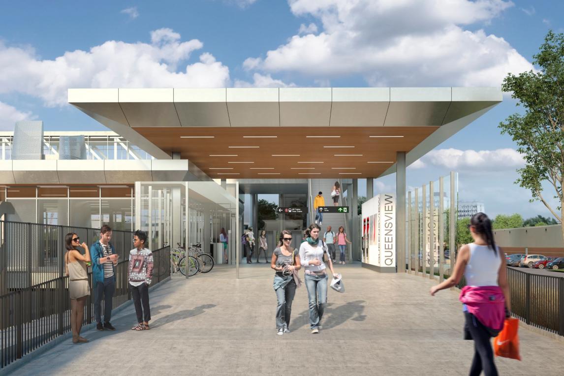
Queensview
Queensview Station is a new station located to the north of Highway 417. The station is to be served by a minimum of one fare-controlled entrance and will be integrated with a new public access pedestrian bridge spanning Highway 417 and landing at Baxter Road, providing a significant new connection for communities north and south of the highway. There will be a north entrance building and entry plaza with access from the enhanced MUP and sidewalk system to allow access from the Queensview Drive and Queensway Terrace North communities. This entrance will also serve the new pedestrian bridge spanning Highway 417.
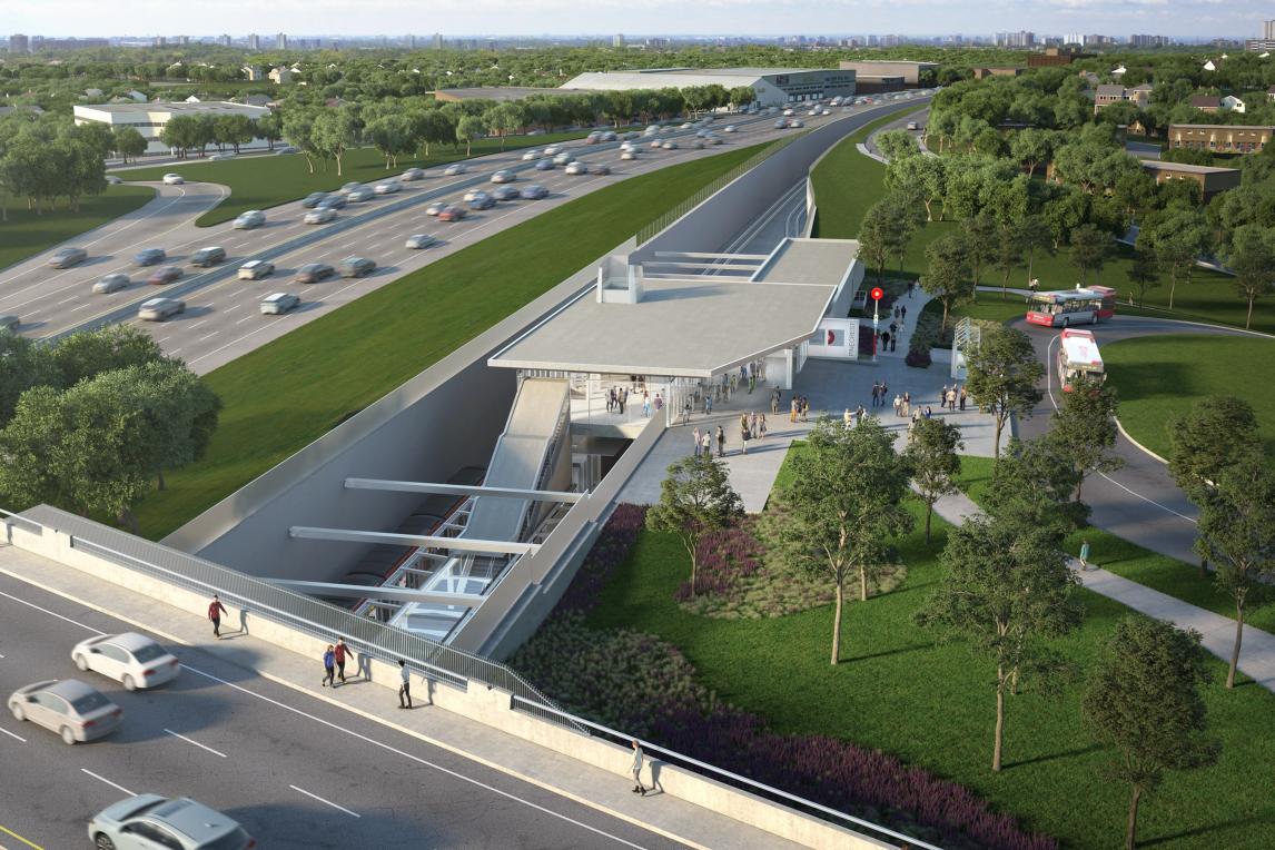
Pinecrest
Pinecrest Station is an existing Transitway Station that will shift south to align with the Confederation Line West alignment. The new Pinecrest Station will be located on the north side of Highway 417 west of Pinecrest Road. Off-street bus facilities will be constructed to support the transfer of customers from bus stops located adjacent to the station. There will be a bi-directional route from Pinecrest Road to the station’s bus stop location and a bus turnaround after the bus stop to return buses to Pinecrest Road. The transfer of customers at this station will not be within a fare paid zone. The station will be connected to Pinecrest Road and Dumaurier Avenue by MUPs, with PPUDO spaces located on Dumaurier Ave with convenient access to the station plaza and bicycle parking in the station plaza area.
Bayshore
Bayshore Station is an existing Transitway Station that is currently located adjacent to Bayshore Shopping Centre and Highway 417. The station will be converted to serve as a BRT/LRT transfer station of the Confederation Line. The station platform will be located to provide convenient access to the surrounding community. The station will have a direct connection to Bayshore Shopping Centre by way of the existing overhead pedestrian bridge and improved pedestrian connections to the west, and east via new and improved MUPs, and to the north with an improved sidewalk to Woodridge Crescent.
Moodie
Moodie Station is an existing Transitway Station that is currently located southeast of the intersection of Moodie Dr and Corkstown Rd. The existing station will be converted to a terminal station serving as the western terminus of the Confederation Line. The station platform will be located between Corkstown Rd and the eastbound off ramp of Highway 417, east of Moodie Dr. The station will facilitate the direct and rapid movement of passengers between local buses, trains, and the adjacent development. A bus platform will be assigned for the shuttle service to and from the Department of National Defence, located northwest of the station on Moodie Dr. PPUDO’s located on the re-aligned and reconfigured Corkstown Rd will allow convenient access to the station by automobile. MUPs and a sidewalk will direct customers to the plaza for entrance to the station and where bicycle parking will be provided.
Moodie Yard / LMSF
Moodie Light Maintenance and Storage Facility (LMSF) will provide additional vehicle storage and perform light maintenance programs such as seat repairs, window replacement, flooring replacement, door repair, electronic component replacement, cleaning and systems testing. The Moodie LMSF will be built to accommodate 24 vehicles opening day, with the potential for phased expansion to get to an ultimate capacity of 90 vehicles.
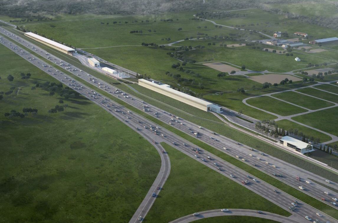
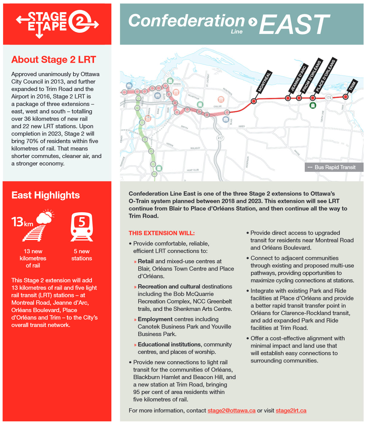
Proposed Phase 2 Extension East
Overview
The Confederation Line East is one of the three major extensions to Ottawa’s light rail transit system. This extension will see LRT continue from Blair Road to Place d’Orléans and go all the way to Trim Road. Revenue service for this extension is planned for 2024.
Extension Highlights
Over 12 kilometres of new rail and 5 new stations including expanding park and ride capacity at Trim. New connections to light rail transit for the communities of Orléans, Blackburn Hamlet and Beacon Hill, bringing 95 per cent area residents within five kilometres of rail. Direct access to upgraded transit for residents near Montreal Road and Orléans Boulevard. Further improves transit service to major centres of employment, shopping and education such as Orléans Town Centre, Canotek Park, La Cité, Place d’Orléans Shopping Centre, Bob MacQuarrie Recreation Complex-Orléans, and more.
Extension Description
The LRT alignment will be north of Highway 174 east of Blair Station, extending along the existing Transitway alignment, passing under Blair Road and the interchange ramps. The rail line will then transition into the median of the highway by crossing above the westbound highway lanes, west of Montreal Road. It will remain at grade in the centre median to Trim Road. The dual LRT tracks will offer stops at five new stations: Montreal Station, Jeanne d’Arc, Orléans Boulevard, Place d’Orléans, and Trim, which will all be located within the median.
Montreal
Montreal Road Station will be a new station located at the crossing of OR 174 and Montreal Rd. The Station will be served by two fare-controlled entrances located on Montreal Rd. One entrance will serve the eastbound lane and one will serve the westbound lane. The platform will be in the median of OR 174, above Montreal Rd, and will be located so that the platform spans Montreal Rd. Bus stops and shelters will be provided in each direction of travel on Montreal Rd. Sidewalks and station entry plazas will be sized appropriately to serve the movement and volume of pedestrians and cyclists along Montreal Rd, the bus stops, and the passengers transferring from bus to train.
Jeanne d'arc
Jean d’Arc Station will be a new station located at the crossing of OR 174 and Jeanne d’Arc Boulevard. The station will be served by two fare-controlled entrances located on either side of Jeanne d’Arc Boulevard. One entrance will serve the northbound lane and one will serve the southbound lane. The platform will be located below Jeanne d’Arc Boulevard in the median of OR 174. The station structure, vertical circulation elements, station entry and entry plaza will be designed and constructed to permit the widening of 18 Jeanne d’Arc Boulevard to an ultimate right of way width of 37.5 metres without major modification to the station elements. The location of the station entrances have been carefully coordinated with the future bridge configuration to accommodate all modes of transportation and to provide sufficient public entry space.
Orleans Blvd (Prom d'Orleans)
Name change.... If you look at the proposal maps, you will see this stop as "Prom D'Orleans", but on the ottawa.ca website, it is now referred to as Orleans Blvd. Pick one, we'll see what the signs say when the station is built.
Orléans Boulevard Station is a new station located at the crossing of OR 174 and Orléans Boulevard. The station will be served by two fare-controlled entrances located on either side of Orléans Boulevard. The platform will be located below Orléans Boulevard in the median of OR 174. Sidewalks and entry plazas will be sized to accommodate the number of pedestrians and cyclists, as required to serve the public along Orléans Boulevard, the bus stops, and the passengers transferring from bus to train.
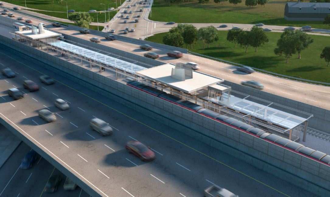
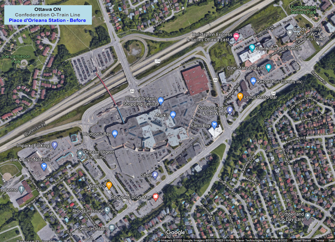
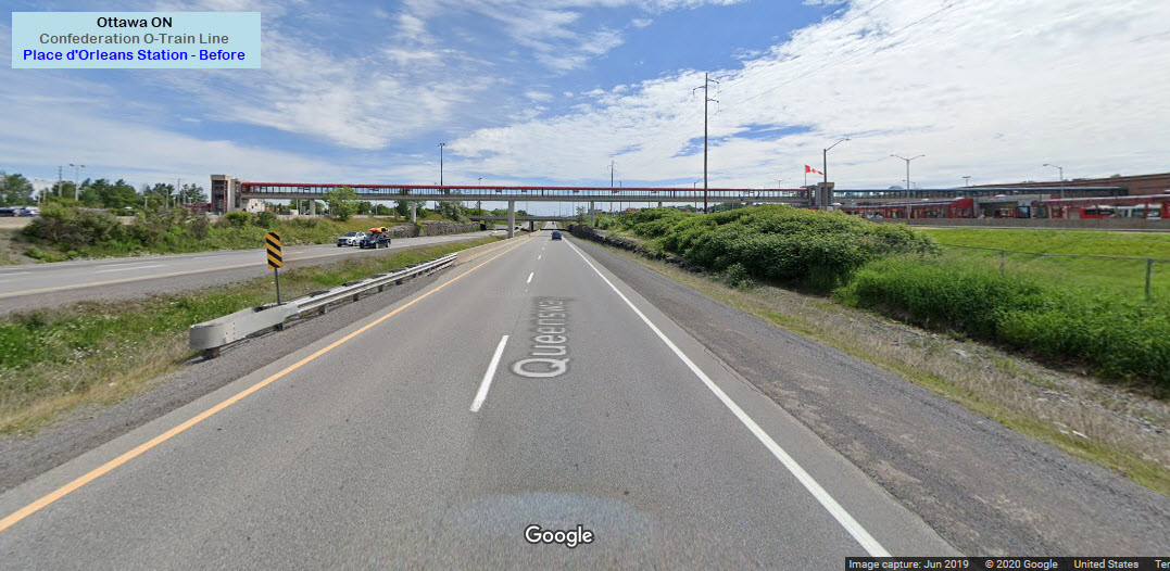
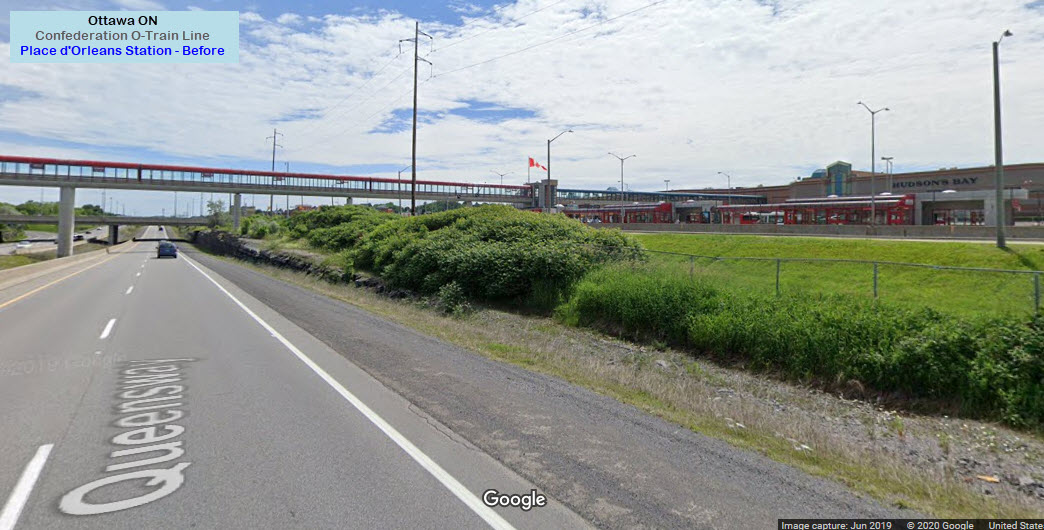
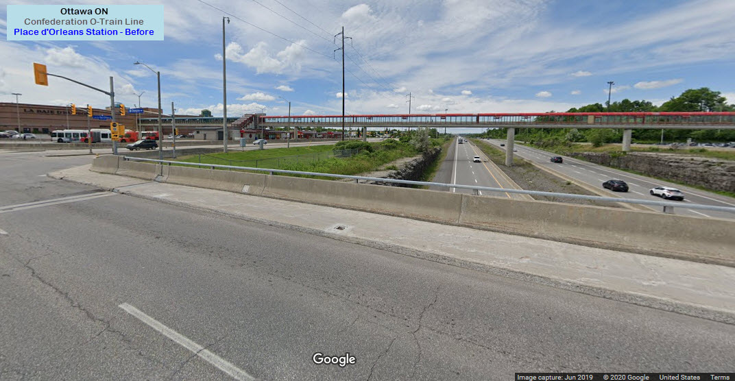
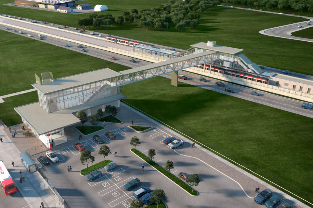
Place d'Orleans
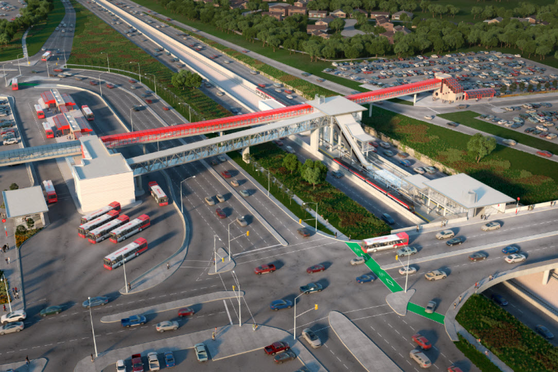
Place d’Orléans Station is an existing Transitway station that is currently located adjacent to Place d’Orléans Shopping Centre and OR 174, which will be converted to serve as a transfer station. The Station will be served by four fare controlled entrances. Two entrances will serve the station from the existing pedestrian bridge; one at each the LRT and bus platform locations. One entrance will be provided to the LRT platform from Champlain Street and an entrance will be provided to the bus terminal from Champlain Street. A connection to the LRT Station, allowing passengers to transfer between bus service and train service without passing through fare control gates and/or revalidating fare payment will be provided from the bus platform area. The station will be designed to allow the bus terminal to remain accessible to the public while securing the train station during train non-operating hours. The existing pedestrian bridge will continue to allow for a connection from the park and ride (and points north of OR 174) and Place d’Orléans Shopping Centre without having to enter a fare gate.
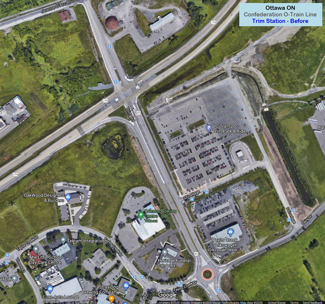
Trim
Trim Station is an existing Transitway station that is currently located southeast of the intersection of Trim Road and OR 174. The existing station will be converted to a terminal station serving as the eastern terminus of the Confederation Line. The train platform will be in the median of OR 174 at the existing intersection of OR 174 and Trim Rd. In order to locate the LRT platform at this location, Trim Rd will be re-aligned to the east of the existing facility and an improved intersection will be constructed, which will have capacity to service the expected future traffic demands. The bus terminal and the park and ride facilities (with a capacity of 1,111 cars) will be located south of OR 174 and east of the existing Trim Rd. The station will be served by one fare controlled entrance providing access from the park and ride area to the station. The station will be designed to allow the bus terminal to remain accessible to the public while securing the train station during non-operating hours. There will also be a new fully enclosed, naturally ventilated, glazed bridge corridor connecting the fare paid entrance to the LRT platform.
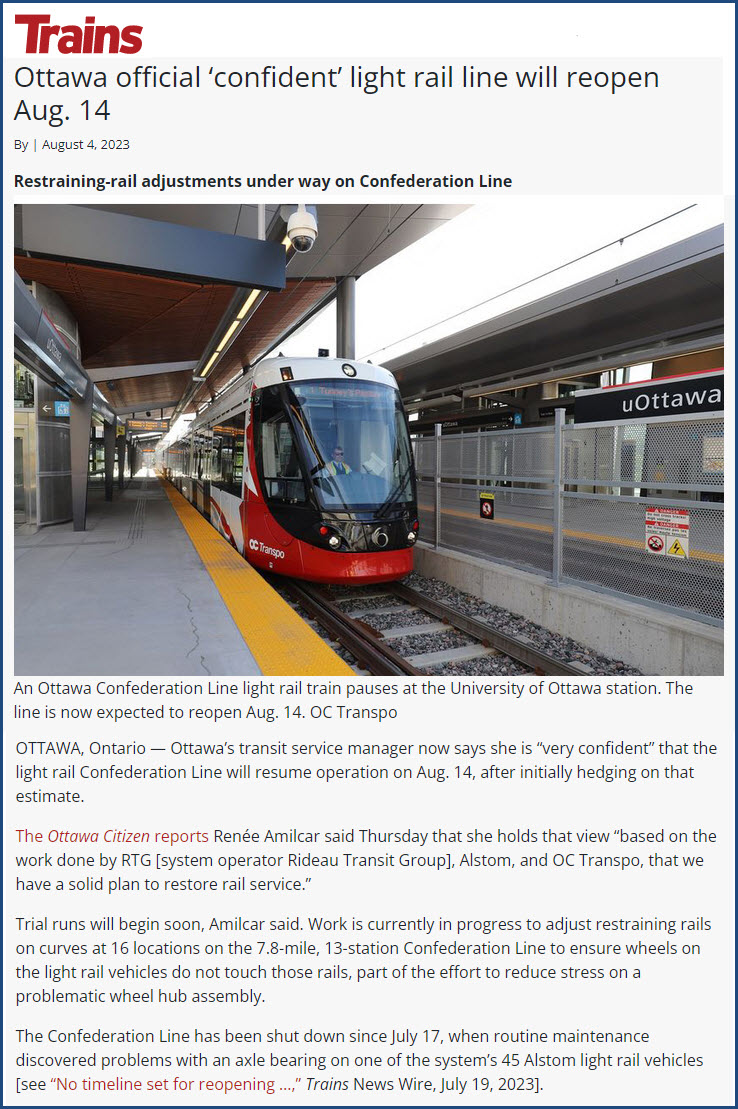
https://www.trains.com/trn/news-reviews/news-wire/ottawa-official-confident-light-rail-line-will-reopen-aug-14/?utm_campaign=News0_TDC_000000_000000_0000000_TDCSubNewsletter&utm_source=ACS&utm_medium=Email&tmsb=54r9lwd&tmrl=3ie3f76&tmsl=tdc-newsletter_nonsub_articles_trnctr&tmty=e&tmcv=6&tmcs=brkou9p&tmpi=XSssTZPvYRvh9_wS
Disclaimers:
I love trains, and I love signals. I am not an expert. My webpages reflect what I find on the topic of the page. This is something I have fun with while trying to help others.
Please Note: Since the main focus of my two websites is railroad signals, the railfan guides are oriented towards the signal fan being able to locate them. For those of you into the modeling aspect of our hobby, my indexa page has a list of almost everything railroad oriented I can think of to provide you with at least a few pictures to help you detail your pike.
If this is a railfan page, every effort has been made to make sure that the information contained on this map and in this railfan guide is correct. Once in a while, an error may creep in :-)
My philosophy: Pictures and maps are worth a thousand words, especially for railfanning. Text descriptions only get you so far, especially if you get lost or disoriented. Take along good maps.... a GPS is OK to get somewhere, but maps are still better if you get lost! I belong to AAA, which allows you to get local maps for free when you visit the local branches. ADC puts out a nice series of county maps for the Washington DC area, but their state maps do not have the railroads on them. If you can find em, I like the National Geographic map book of the U.S..... good, clear, and concise graphics, and they do a really good job of showing you where tourist type attractions are, although they too lack the railroads. Other notes about specific areas will show up on that page if known.
Aerial shots were taken from either Google or Bing Maps as noted. Screen captures are made with Snagit, a Techsmith product... a great tool if you have never used it!
By the way, floobydust is a term I picked up 30-40 years ago from a National Semiconductor data book, and means miscellaneous and/or other stuff.
Pictures and additional information is always needed if anyone feels inclined to take 'em, send 'em, and share 'em, or if you have something to add or correct.... credit is always given! Please be NICE!!! Contact info is here
Beware: If used as a source, ANYTHING from Wikipedia must be treated as being possibly inaccurate, wrong, or not true.
RAILFAN GUIDES HOME
RAILROAD SIGNALS HOME
NEW 9/23/2020, AUG03/04/2023
Last Modified 05-Aug-2023