In General
Map
Details
Pictures
Bridges
Signals
Floobydust
RAILFAN GUIDES HOME
RAILROAD SIGNALS HOME
Location / Name:
Manhattan NY, New York County
Queens NY, Queens County
What's Here:
Adding LIRR access from Sunnyside Yard (Queens) to Grand Central Terminal (Manhattan)
Data:
GPS Coordinates: as needed
Phone A/C: 212 in Manhattan, 718 in the Queens
ZIP: n/a
Access by train/transit:
Manhattan Side:
- Amtrak / NJT / LIRR at Penn Station
- Metro North / LIRR at Grand Central Terminal
- #1, 2, 3 IRT and A, B, C IND Subway Lines at Penn Station
- #4, 5, 6, 7 IRT Lines Subway Lines at GCT
- Subway shuttle service between GCT and Times Square
Queens side:
- #7 IRT and N, W BMT Subway Lines at Queensboro Plaza (elevated)
- #7 IRT Subway Line at 33rd St/Rawson St and Hunters Point stations
- E, M, R IND Subway Lines at Queens Plaza (underground)
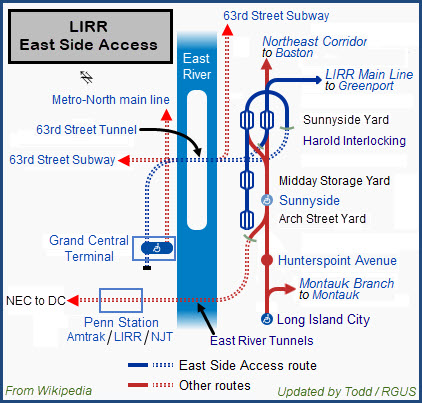
- LIRR at the Hunterspoint and Sunnyside stations
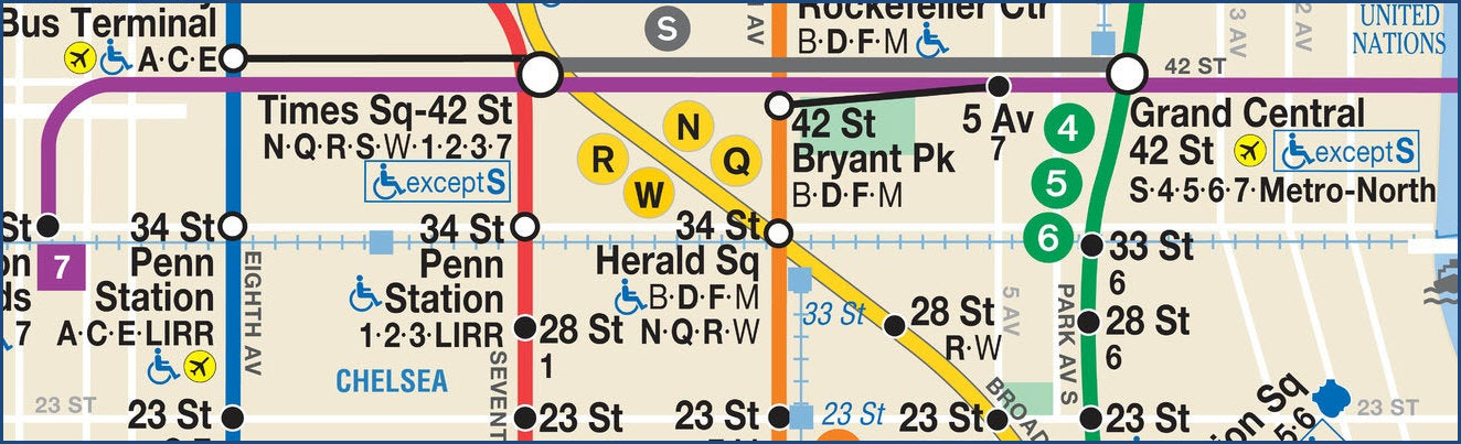
Manhattan side subways
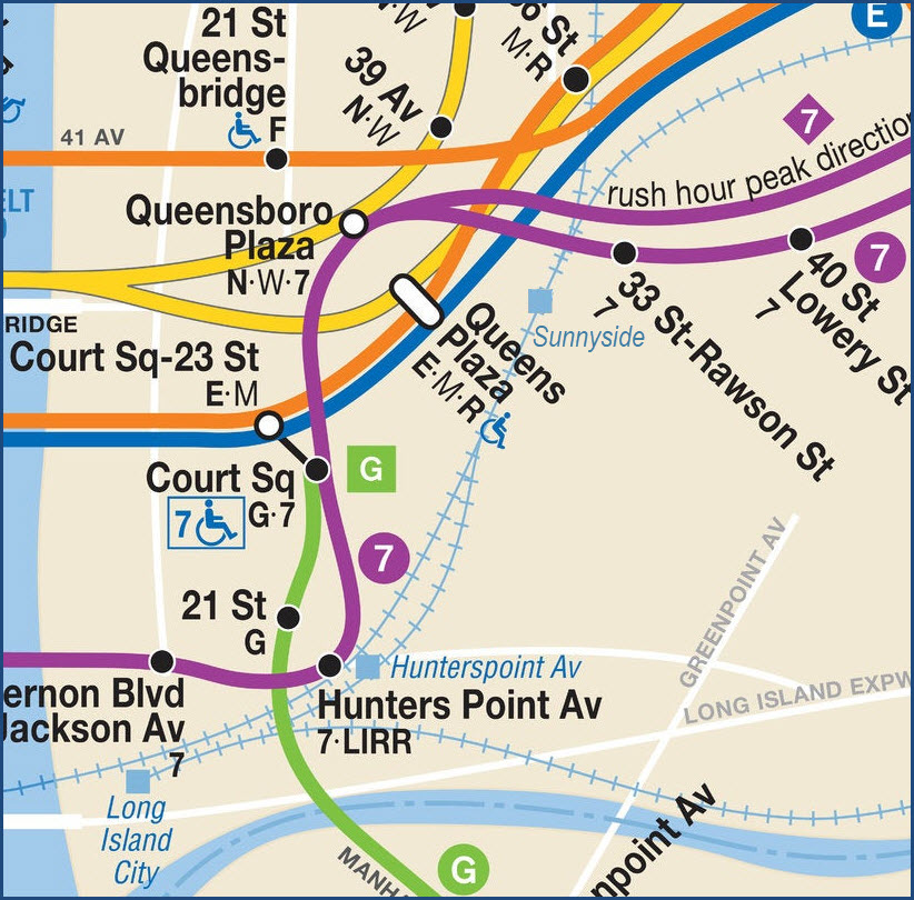
Queens side subways
The Scoop:
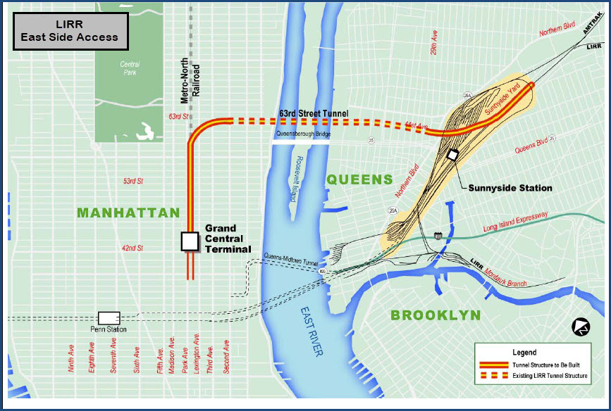
The East Side Access Project is the largest undertaking for the Long Island Railroad in 100 years.
Simply put, it's purpose is to add access to Grand Central Terminal.
By giving the Long Island Railroad access to Grand Central, it will accomplish two things - it will provide commuters with an alternate destination on the Manhattan side, and it will alleviate some of the "crunch" at Penn Station.
According to the various sources of information on the project, here are some of the original goals:
- Provide access for the Long Island RR to Grand Central Terminal.
- Tunnel from the 63rd St Tunnel to Grand Central Terminal.
- Construct 5 new "softbore" tunnels from Sunnyside Yard to the 63rd St Tunnel.
- Construction of an additional loop track.
- Provide 2 bypasses for Amtrak trains for conflict free passage thru Harold Interlocking.
- Relocate the Car Wash due to changes in the Loop Tracks.
- Reconfigure Harold Interlocking.
- Update the Harold Interlocking signaling from relay to computer based technology.
- A new LIRR Sunnyside station below and adjacent to the Queens Blvd Bridge.
- A single soft-ground bored tunnel to provide MTA New York City Transit (NYCT) access to a planned future storage yard in Sunnyside Yard.
As we cover the project, we'll see how many items from the above list they actually accomplished.
Acknowledgements:
Denver Todd
Google Maps
Bing Maps
Open Railway Map
Wikipedia
Websites and other additional information sources of interest for the area:
https://en.wikipedia.org/wiki/East_Side_Access
https://en.wikipedia.org/wiki/63rd_Street_Tunnel
https://new.mta.info/project/east-side-access
https://new.mta.info/projects/east-side-access/east-side-access-publications
https://www.dec.ny.gov/data/DecDocs/241006/Report.HW.241006.2007-06-01.mta_lirr_esa_environmental_status_and_construction_plan%20_for_the_queens_a.pdf
https://www.transit.dot.gov/sites/fta.dot.gov/files/docs/foia/132826/esa-monthly-pmoc-report-june-2018.pdf
https://pedestrianobservations.com/2011/07/05/sunnyside-junction-proposal/
https://www.amtrak.com/content/dam/projects/dotcom/english/public/documents/corporate/nec/reports/amtrak-vision-for-the-northeast-corridor-july-2012.pdf
https://api.sunnysideyard.nyc/sites/default/files/2020-02/Sunnyside-Yard-Feasibility-Study-2017-Full-Repor_0.pdf
https://new.mta.info/projects/harold-interlocking
https://www.dec.ny.gov/data/DecDocs/241006/Report.HW.241006.2002-01-01.environmental_status_and_construction_plan_for_the_queens_alignment.pdf
https://sunnysideyard.nyc/
https://medium.com/@akgrimmett/grand-centrals-secret-entrances-611b9bda3630
https://www.nycurbanism.com/east-side-access
Since this page is about a project, and not really something that can be seen, we're going to dispense with our usual getting here info.
Maps
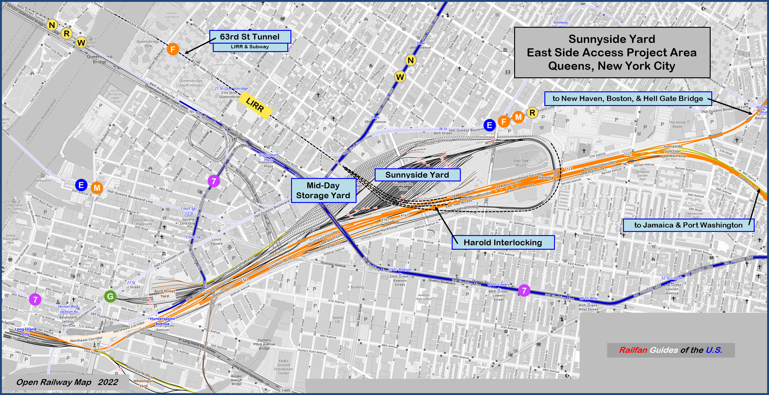
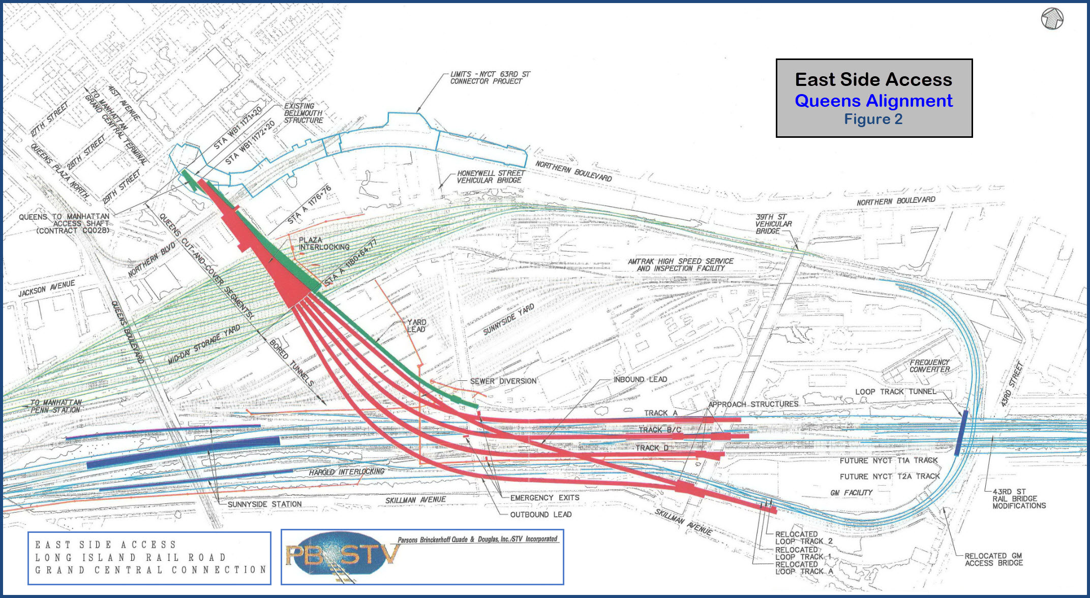
The tunnels under Sunnyside Yard from an early proposal.
From Wikipedia: The Metropolitan Transportation Authority (MTA) began construction of several infrastructure improvements to the junction area in 2009, but a major project to redesign and rebuild the interlocking required additional funding. In May 2011, a $294.7 million federal grant was awarded to address congestion at the interlocking. The work will allow for a grade-separated route between the East River Tunnels and the Hell Gate Bridge for Amtrak trains traveling to or from New England, thus avoiding LIRR traffic. Northeast Corridor trains from the Hell Gate Bridge and New England would be able to avoid the junction entirely, while trains to the Hell Gate Bridge and New England would be able to bypass a major section of the junction. As part of the project, Amtrak's car-washing facility within Sunnyside Yard, as well as several small Amtrak buildings, are being relocated. The MTA is constructing and managing the improvement project as part of the adjacent East Side Access project to bring the LIRR to Grand Central Terminal. As of late 2017, the MTA estimated that East Side Access would be substantially complete in 2022. By November 2018, two of three East Side Access tunnel portals had been built at Harold Interlocking, and only the centermost portal remained to be built.
Work on the Northeast Corridor bypass started in 2013. However, by October 2015, the tunnels were behind schedule because Amtrak and the MTA could not cooperate on track access schedules. These delays ultimately raised construction costs by almost $1 billion as of April 2018, and in a report that month, the MTA attributed the delays to a lack of cooperation on Amtrak's part. The work at Harold Interlocking also included the installation of a microprocessor-based interlocking logic, replacing the old relay-based one. end Wiki
 From
Wikipedia and modified, their version is somewhat simplified and confusing
From
Wikipedia and modified, their version is somewhat simplified and confusing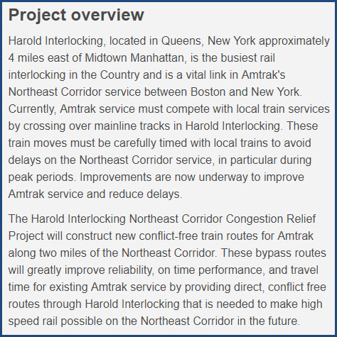
 From the second link above
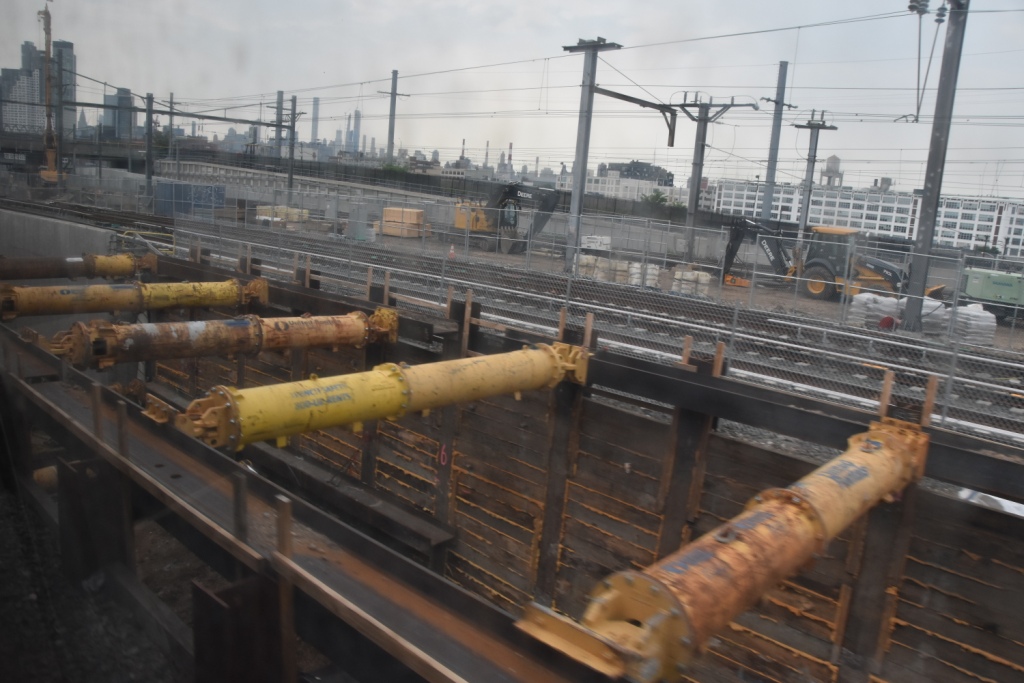
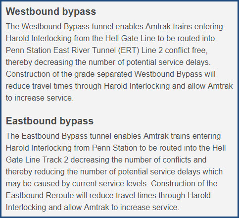
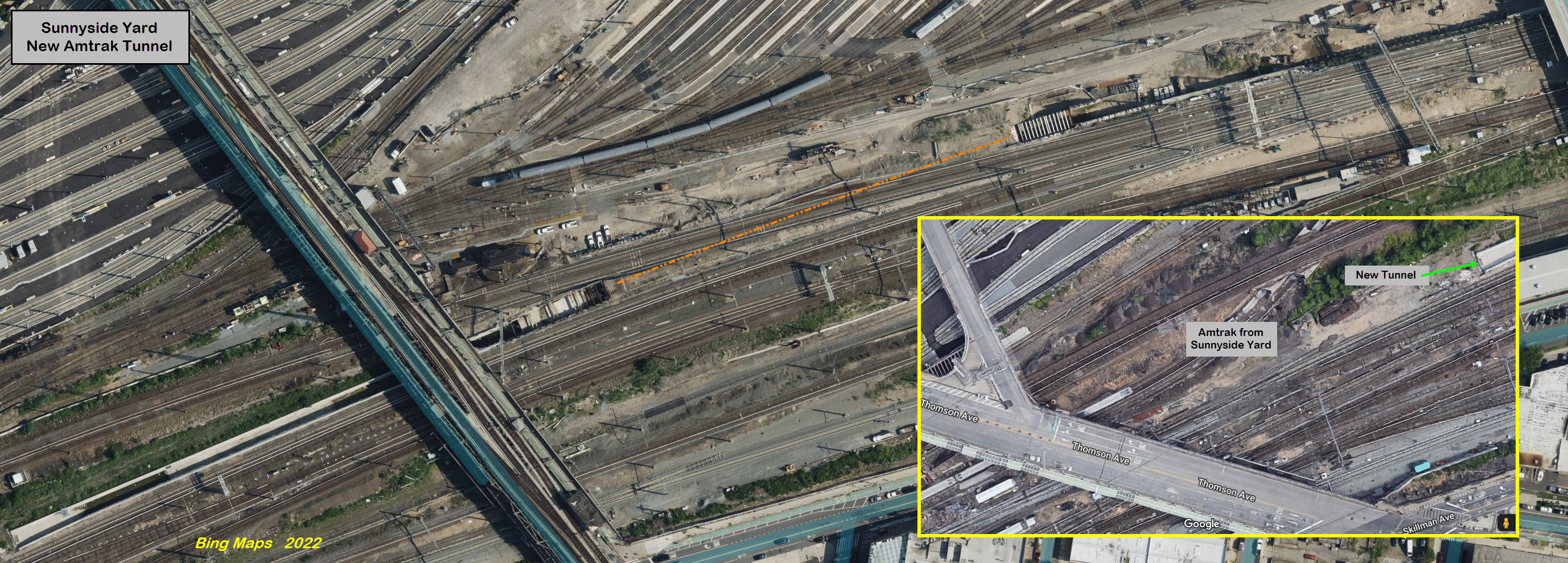
A couple of pictures of the new tunnel construction from the NB Amtrak NEC line.
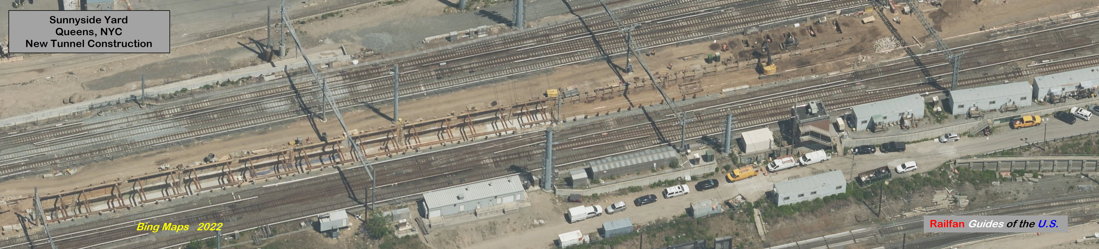
This new tunnel will allow SB (WB in MTA/Amtrak parlance) Amtrak trains conflict free passage thru Harold Interlocking.
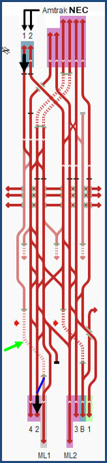
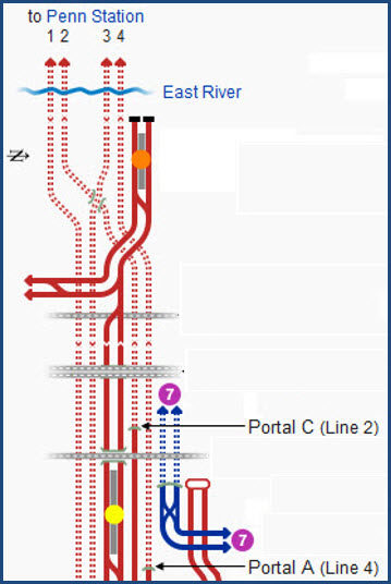
The track diagrams below are from Wikipedia, and, it appears that Wikipedia left out a connection where I put the blue line, otherwise Amtrak trains would go into the LIRR yard, as ML1 and ML2 are Long Island tracks into the Long Island City station and yard. The new tunnel is pointed to with a green arrow.
The
The
The
Did U Know?
None for now......
Disclaimers:
I love trains, and I love signals. I am not an expert. My webpages reflect what I find on the topic of the page. This is something I have fun with while trying to help others.
Please Note: Since the main focus of my two websites is railroad signals, the railfan guides are oriented towards the signal fan being able to locate them. For those of you into the modeling aspect of our hobby, my indexa page has a list of almost everything railroad oriented I can think of to provide you with at least a few pictures to help you detail your pike.
If this is a railfan page, every effort has been made to make sure that the information contained on this map and in this railfan guide is correct. Once in a while, an error may creep in :-)
My philosophy: Pictures and maps are worth a thousand words, especially for railfanning. Text descriptions only get you so far, especially if you get lost or disoriented. Take along good maps.... a GPS is OK to get somewhere, but maps are still better if you get lost! I belong to AAA, which allows you to get local maps for free when you visit the local branches. ADC puts out a nice series of county maps for the Washington DC area, but their state maps do not have the railroads on them. If you can find em, I like the National Geographic map book of the U.S..... good, clear, and concise graphics, and they do a really good job of showing you where tourist type attractions are, although they too lack the railroads. Other notes about specific areas will show up on that page if known.
Aerial shots were taken from either Google or Bing Maps as noted. Screen captures are made with Snagit, a Techsmith product... a great tool if you have never used it!
By the way, floobydust is a term I picked up 30-40 years ago from a National Semiconductor data book, and means miscellaneous and/or other stuff.
Pictures and additional information is always needed if anyone feels inclined to take 'em, send 'em, and share 'em, or if you have something to add or correct.... credit is always given! Please be NICE!!! Contact info is here
Beware: If used as a source, ANYTHING from Wikipedia must be treated as being possibly inaccurate, wrong, or not true.
RAILFAN GUIDES HOME
RAILROAD SIGNALS HOME
NEW 09/14/2022, SEP15/18/2022
Last Modified 18-Sep-2022