
In General
Getting Here
Maps
Pictures
Parkton
Wiseburg Rd
Monkton
Glencoe/Glencoe Rd
Sparks/Sparks Rd
Phoenix/Phoenix Rd
Ashland/Papermill Rd
Cockeysville
Texas
Lutherville
Riderwood
Ruxton
Lake
Hollins
Mt Washington
Calvert St
Signals
NC History Time Line
Floobydust
USGS Maps
RAILROAD SIGNALS HOME
Location / Name:
Parkton MD, Baltimore County
What's Here:
Nothing now, it's a rail trail
Formerly:
- PRR Station / Depot
- Wye
- 3 track yard
- Signals
Data:
GPS Coordinates: 39.64114, -76.65916
Phone A/C: 410/443cell
ZIP: 21120
Milepost: 27.8
Access by train/transit:
None
Geography:
Very, very hilly
The Scoop:
Parkton MD is a community of Baltimore County MD located 18 miles north of Towson, the county seat, and about 5 miles south of the MD/PA line.
Parkton resides on what used to be a popular north-south running railroad, originally constructed by the Baltimore & Susquehanna RR having been incorporated on February 13, 1828, making it Baltimore's second railroad.
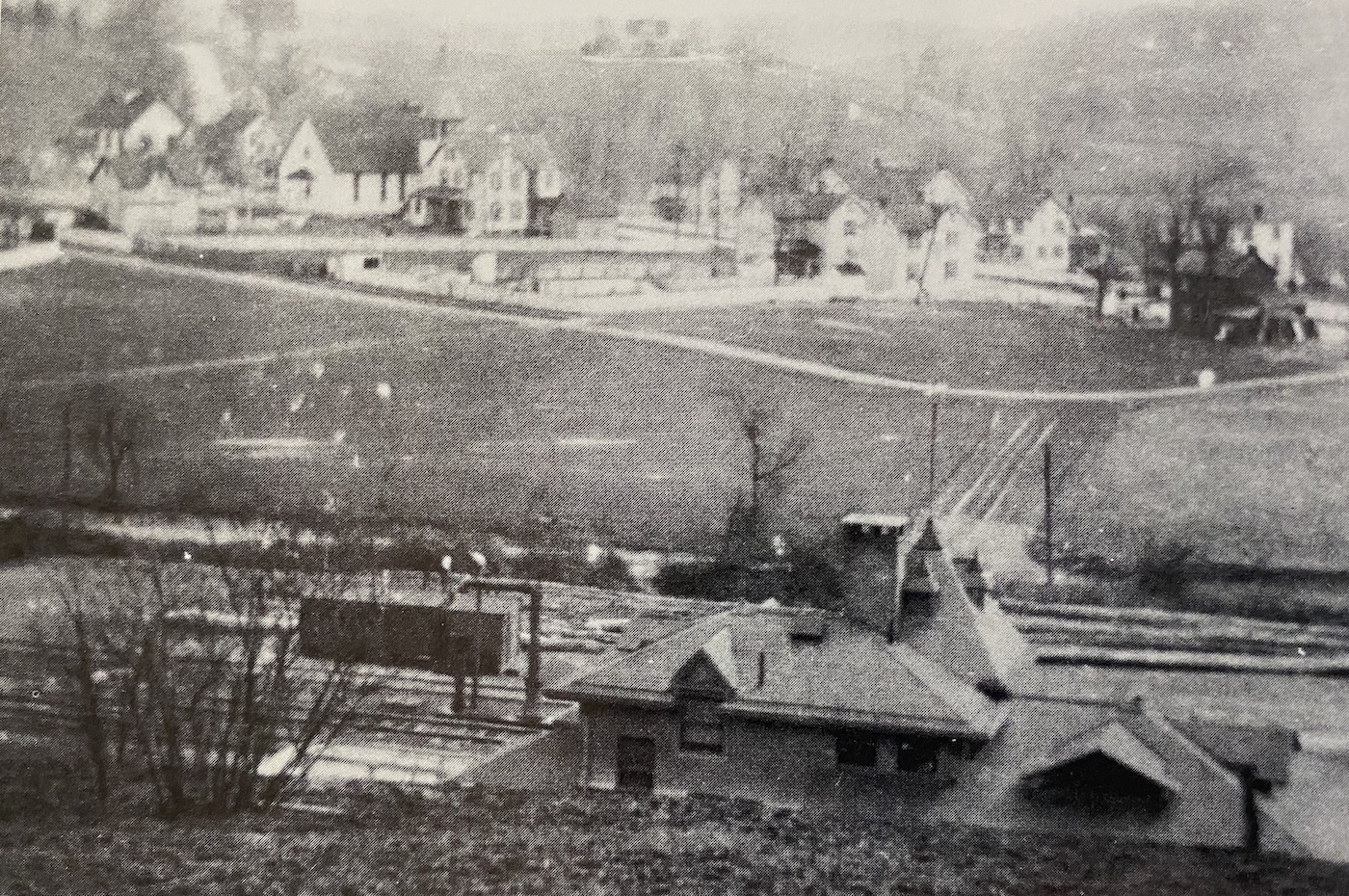
The park sign for this location, along with a nicely detailed map, states: The spot where you are standing was once one of the busiest centers for the Northern Central Railroad in the state of Maryland. There were two 90 railroad car sidings, two crossover switches, three locomotive sidings for repairs and storage, a wye turnaround, the remains of which can still be seen on the west side of I-83, for a complete direction change, two through-tracks north and south, an attended train station, a water tank and water stand pipe for steam locomotives.
The Pennsy used to run a local passenger train up to Parkton, the Parkton Local, where it ended it's northward journey -- hence, the wye, station, and facilities to keep the engines here until the following morning for the return trip into Baltimore.
Because of it's close proximity to Washington DC (and other factors), the NCR saw the funeral trains for President's Harrison in 1841, Taylor in 1850, Lincoln in 1865, McKinley in 1901, and Harding in 1923. (HSBC)
The Parkton Local used to come out of Baltimore and service the growing communities along the Northern Central. Taken from Google AI, which is quoting from Alan Brougham's BULL SHEET: The Pennsylvania Railroad’s "Parkton Local" commuter train ran for 91 years. The popular daily service, which traveled 28 miles between Calvert Station in downtown Baltimore and Parkton, Maryland, operated from 1868 until the final run on June 27, 1959. The commuter line was eventually discontinued due to declining ridership following the construction of Interstate 83 and increased automobile ownership.
From Calvert Street to Parkton, there were 24 stops. The map below shows the entire line, TO SCALE and comes from OPEN RAILWAY MAP -- it also shows other rail lines of today and yesteryear. I've also taken the liberty of denoting two other depots which are NOT on the Northern Central, just because I can..... :-) It is interesting to note that there was not a stop at Lake Roland at Hollins (what was originally Relay, but it's use was discontinued in order to avoid confusion with a B&O station of that name) - my guess for this is (maybe) because the Greenspring Branch had it's own passenger trains, and the Pennsy figured it did not need a transfer point between the two. Would loved to have seen the hotel that was there!
A sad note: I got my drivers license in May of 1969, the last day of passenger service from Baltimore to Harrisburg was May 1st, 1971. That gave me two years to go out and take pictures of that lone E8 pulling a single car up and down the line -- over 700 chances to get pictures, and I only caught it maybe two, three, or four times! Someone should knock me upside the head. In my defense, when your that young, you figure things will be around forever. And then came Hurricane Agnes in 1972 and took it ALL away from us! Dang. And on top of that, to make matters worse, I NEVER rode the line. My best friend John did - jealous.
Two sources were used a lot to do this page: the History Society of Baltimore County (HSBC), and the write-up by Frank Wrabel. Frank, BTW, worked at Kleins hobby shop when it was in Cockeysville!
On Wednesday June 3rd, 2026, I ventured 'out' on the Northern Central rail-trail with my daughter Jenny riding shotgun :-), taking pictures of just about everything useless I could find. It's been a while, so I was surprised to see that the park replaced a "fake" signal with a real signal in Monkton, although their description is bogus for some of it. I noticed in Glencoe that there is a still some slate stone along the trail, showing the visitor where the edge of the platform was. I will be posting pictures as I get the time. Need to go back to Parkton and continue further north from there.
On Friday June 5th, 2026, I stopped by the Historical Society, met with a couple of the volunteers there, and joined the Society. I got a form to request some Northern Central photos for use on this page after talking with Jim, who is also railfan of sorts, and dabbles with an N scale layout! It was a very enlightening and interesting visit.
The following is a history of the Parkton Local from By Martin K. Van Horn
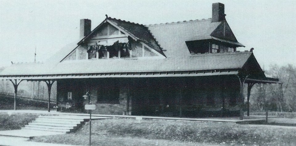
Mention the Northern Central Railway to any railfan or resident of north central Maryland who knows to which part of the Pennsylvania Railroad you refer, and several things come to mind: a railroad that dates from the primitive days of transport mode, operating on a roadbed that is less than 45% tangent track; a railroad that carried the Washington-to-Chicago first-class passenger traffic of the PRR; in later years, a nearly passenger-only railroad when that was the least lucrative part of railroad business; and, most of all, the Parkton Local and the self-propelled railcars that became synonymous with the name.
Not all Parkton Local trains were serviced by the "gas cars" - there were just as many locomotive-hauled trains. It was only in later years, when subsidized automobile competition on public highways cut deeply into revenues that the economical railcars replaced many locomotive-hauled trains to hold down operating costs.
In the early years, the Parkton Local was not even the Parkton Local; it was the Cockeysville Local. Many commuter runs operated between Calvert Station in Baltimore and the wye and terminal storage tracks that then existed at Cockeysville, while only two accommodation trains terminated at Parkton. In fact Cockeysville was 15 miles from Calvert Station, the same distance as Green Spring Junction on the Green Spring branch. An intensive commuter service thrived on this two-prong line in the years between the turn of the century and World War I. The seven miles from Calvert Station to Hollins at the southern tip of Lake Roland was thick with commuter trains. At Hollins, the Green Spring locals turned west and operated 8.6 miles over the single-track Green Spring branch to a junction with the Western Maryland Railway approximately one mile south of Owings Mills. The Cockeysville trains continued north on the double-track Northern Central mainline through Ruxton, Sherwood (Riderwood), Lutherville, and Timonium to their terminus.
One interesting tradition of the "Gilded Age" were the "Owl" trains, midnight commuter runs on the Main and Green Spring branch lines to take theatergoers back to their homes after the curtain had fallen.
Ruxton-Riderwood provided most of the business for the locals and some trains cut back at Riderwood through the agency of a mile-long siding central to both tracks that stretched back to Ruxton. It was possible to cross over and run around the cars of a train by means of this sidetrack thus reversing the train. Trains could be held on this siding, also, until the demands of the schedule required their reappearance on the mainline.
In the post-World War I period, the PRR, which had effected a 999-year lease of the Northern Central in 1914, lengthened the commutation district to Parkton. The PRR was possibly anticipating growth of the metropolitan area, and there were existing facilities for locomotive service and train storage at the Parkton yard. Eventually all local trains ran through to Parkton. In this same period, Green Spring local service declined sharply as state-built tax-supported roads replaced the dirt tracks of the 19th century. The Green Spring locals soldiered on in diminishing numbers until the onset of the Great Depression. The last run came on Thursday, August 17, 1933.
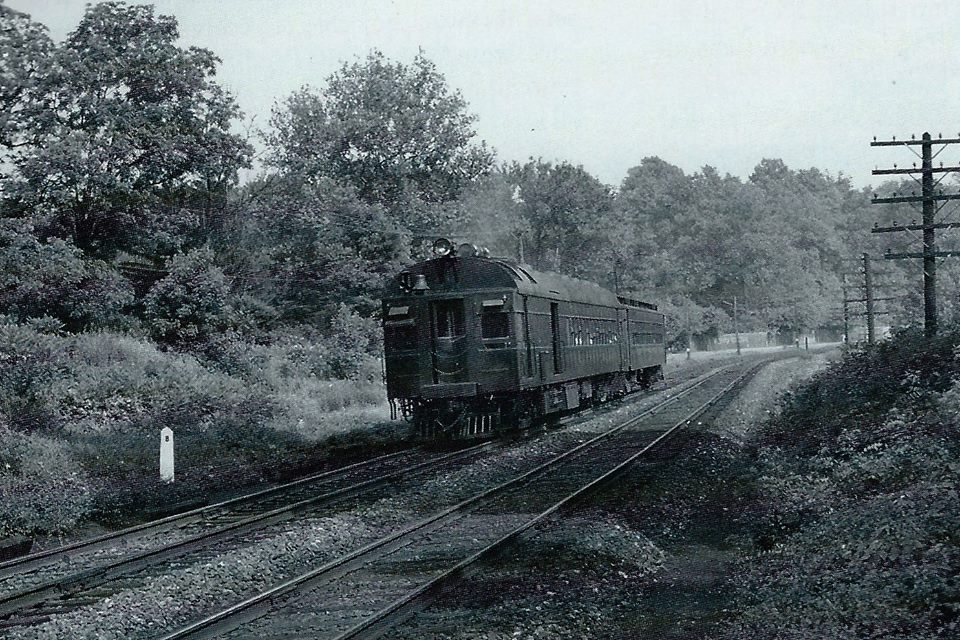
Surviving the doldrums of the Depression, the Parkton Local was given a new lease on life by the tire and gas rationing of World War II. (There is a lesson here for those who are farsighted enough to see the solution to the oil crisis, air pollution problems, and balance of payments due to foreign nations.) During this period, the "gas cars" were joined by pretty, high-wheeled "E" class Atlantic-type locomotives that had hauled the grand mainline express trains 30 to 40 years earlier. They typically hauled three or four P54 commuter coaches, which were identical to the MP-54 electric multiple-unit commuter cars used on the electrified PRR lines except for the lack of motors, controls, headlights, etc. They did have the distinctive porthole and windows the same as their electric cousins that gave them their nickname "Owl-face." A single P-54 would also serve as a trailer car for the self-propelled railcars. In the 1950's, diesel road-switcher type locomotives that could also be used for more lucrative freight business replaced the passenger steamers on the locals. The P54 coaches went elsewhere, and longer P70 coaches from mainline service came to serve the NC commuters.
The "gas cars" were always thus known, a short version of their real name: gas-electric cars. Later, the gas-car appellation continued after more efficient diesel engines had been installed and they had become "oil-electric" cars. In either case, the internal combustion engines, known as the prime mover, drove an electric generator which supplied 600 volts of direct current for electric traction motors geared to the wheels of the front truck. The cars were bidirectional when operated as single units, but the end with the engine, generator and motors was nominally the front. When hauling a trailer car, the trailer had to be turned at the end of the run so that the trainmen and passengers could pass from car to car without having to pass through the engine compartment.
Although the gas cars looked alike to the average layman, the fact that they were built at different times and rebuilt over the years meant that only small groups were identical or similar. For example, of the last three cars assigned to the Parkton Local in 1957, nbr. 4662 had a low-arch roof, two small Cummins diesel engines, and the trailer-end had no separate engineer's cab but rather the engineer had to occupy the platform in front of the passenger door. On the other hand, nbrs. 4666 and 4667 had high-arch roofs, one large Hamilton diesel engine and a separate engineer's cab on the extension of the rear platform. On these two "big" cars, the restroom was located on the opposite (left) side of the platform extension.
The Parkton Local operated with a "status quo" existence through the early 1950's, but the handwriting was on the wall. In fact, it was right outside the walls of Penn Station where the initial construction began on the Jones Falls Expressway. The PRR took immediate steps to discontinue the Parkton Local, knowing it would take some time to get the required permission from the Maryland Public Service Commission. There was strong and organized opposition to service cuts already being manifested by the Northern Central Railway Commuters Association. The PRR began a process whereby the costs of operating the Parkton Local were inflated by means of physical maneuvering and bookkeeping. The latter was easy: the diesel road switchers were used in freight AND commuter service, but ALL costs of operation were charged to the Parkton Local. One ploy that did not work was the attempt to cut service back to Glencoe. This would have eliminated some passenger revenue without any saving in operating costs since Glencoe had no turning facilities or storage yard and the trains would have had to have been deadheaded to Parkton anyway or brought all the way back to Baltimore empty. This attempt was made in 1957, and was rejected by the Public Service Commission.
It was well known by 1958 that the Parkton Local was on borrowed time. The PRR petitioned to discontinue service. After the usual hearing and testimony, permission was granted effective after the last trips on Saturday, June 27, 1959.
Many photos on this page come from my other pages/locations (read: duplicated) along the Parkton Local route, but those pages DO contain lot's more than what is presented on this page, refer to them if you want to know more:
Monkton
Glencoe
Cockeysville
Texas
Timonium
Lutherville
Riderwood
Ruxton
Acknowledgements:
Google Maps
Google Streetview
historicbridges.org
Frank Wrabel
Historical Society of Baltimore County, V40/issue1&2, Autumn/Winter 2008
kilduffs.net
Charles T. Mahan *
Herb H. Harwood *
Bob Dover
Steven Allen
Warren E. Olt *
Milton A. Davis via Frank Wrabel
Frank Kozempel via Frank Wrabel
EBay
* = WELL known local railfan photographers from the 1950's and 60's, all of whom I had the honor of knowing!
Websites and other additional information sources of interest for the area:
https://www.hmdb.org/m.asp?m=152205
http://kilduffs.net/travels-through-maryland/old-maryland-train-stations/parkton-baltimore-county-train-station-maryland/
https://jbritton.pennsyrr.com/index.php/tpm/hobo-s-guide-to-the-pennsy/latest-on-location-articles/770-on-location-528-parkton-md
https://www.pinterest.com/pin/102949541476743707/
https://wynninghistory.com/2025/07/17/a-story-from-the-building-of-the-northern-central-railroad-1850s/
http://www.trainweb.org/oldmainline/ncr4.htm
https://www.hsobc.org/wp-content/uploads/2017/06/htv040n1.pdf Thorough history of Parkton by Frank Wrabel, with many excellent period maps
https://en.wikipedia.org/wiki/Northern_Central_Railway
https://jbritton.pennsyrr.com/index.php/tpm/475-northern-central-railway Another good history of the NCRwy
http://kilduffs.net/travels-through-maryland/old-maryland-train-stations/cockeysville-train-station-maryland-2/
https://hsobc.pastperfectonline.com/Photo/8FADBE28-C76A-4E1C-B08F-414719586051
http://www.trainweb.org/oldmainline/ncr9.htm
https://www.baltimorecountymd.gov/files/Documents/Planning/historic/Light_Rail_History_and_Scenery.pdf
https://www.youtube.com/watch?v=1LXV-YYyTbg Video by Zach Ventures about the NCR in Cockeysville
https://www.youtube.com/watch?v=HUYP13XhosU Video by Zach about the Greenspring Branch
https://www.baltimorecountymd.gov/files/Documents/Planning/historic/Light_Rail_History_and_Scenery.pdf
https://www.prrths.org/
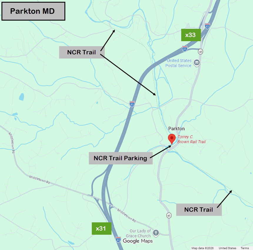
From the south: IE: Baltimore..... Take exit 31 off of I-83, go east on Middletown Road till you get to York Rd, MD45. Take a left and head north. Go about 9/10 of a mile (1.6km), and take a left onto Frederick Rd. Follow that around and it will take you to the trail.
From the north: IE: York PA: Take exit 33, which dumps you onto York Rd, MD45, take a left, continuing south bound. In 1.24 mi (1.99 km), veer to your right following the smaller road, this will take you to the trail. As of 2024, Google Streetview is showing this road closed to get to the trail, but that might be temporary thing.....
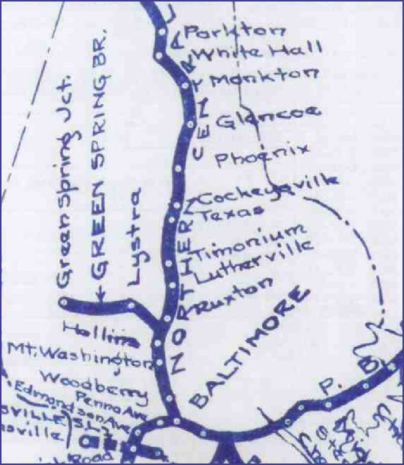
Partial area of a map found in reference (4), showing the route of the Parkton Local on the NCR
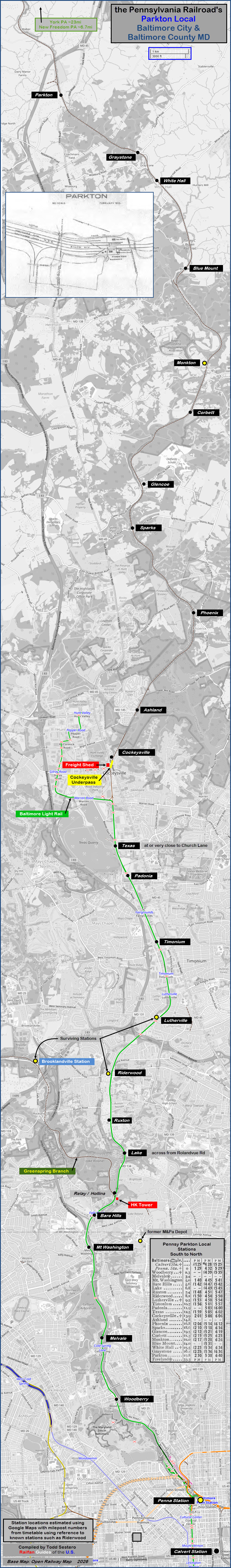
Above, note that Open Railway Map got two of the light rail stations named
incorrectly, do you know which ones?
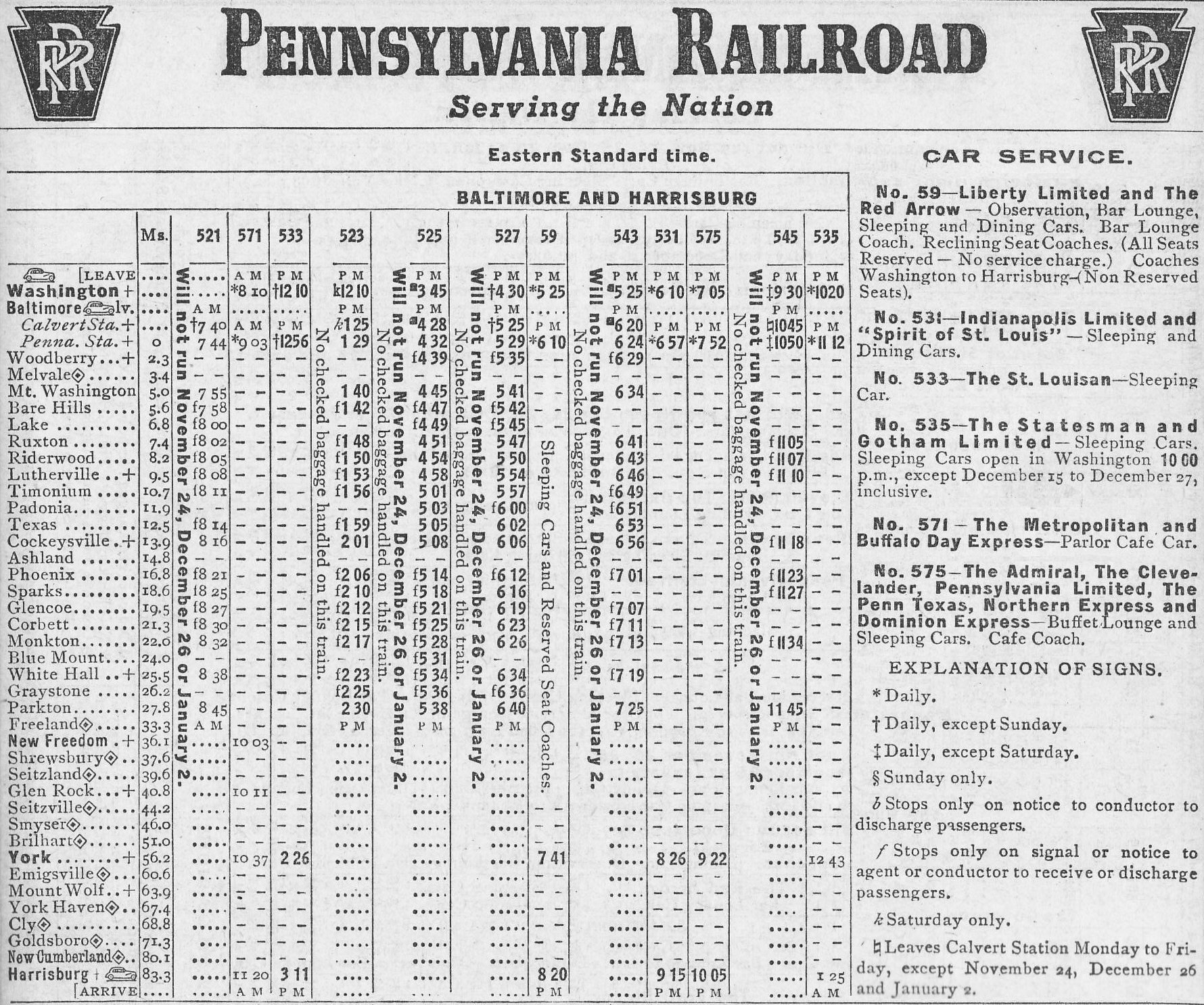
A Pennsy schedule showing northbound trains from Washington DC and Baltimore, up the Northern Central.
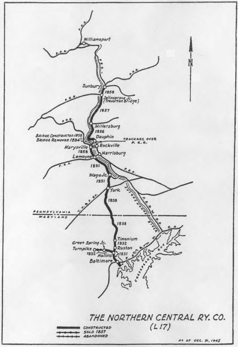
Map of the Northern Central Rwy, from the History of Parkton by Frank Wrabel
Actually, by the time this map was done in 1925, the NC had been part of the
PRR for 11 years (absorbed January 1st, 1914),
however, the takeover started in 1861 when the Pennsy bought a controlling
interest in the Northern Central.
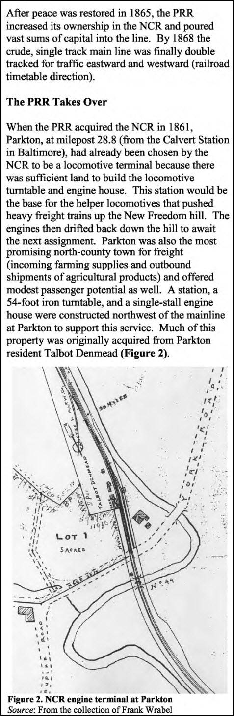
Parkton
 1
1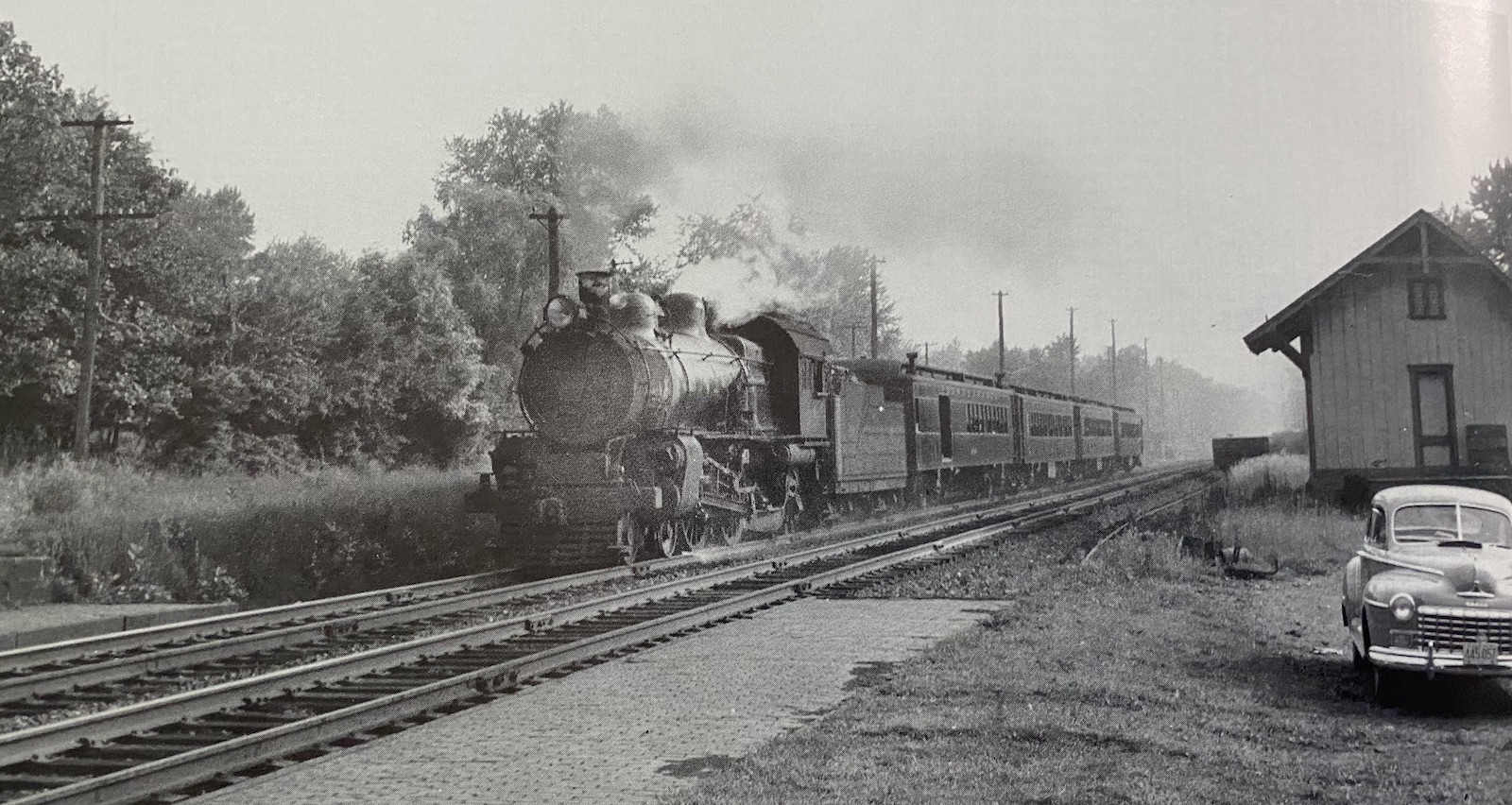 2
2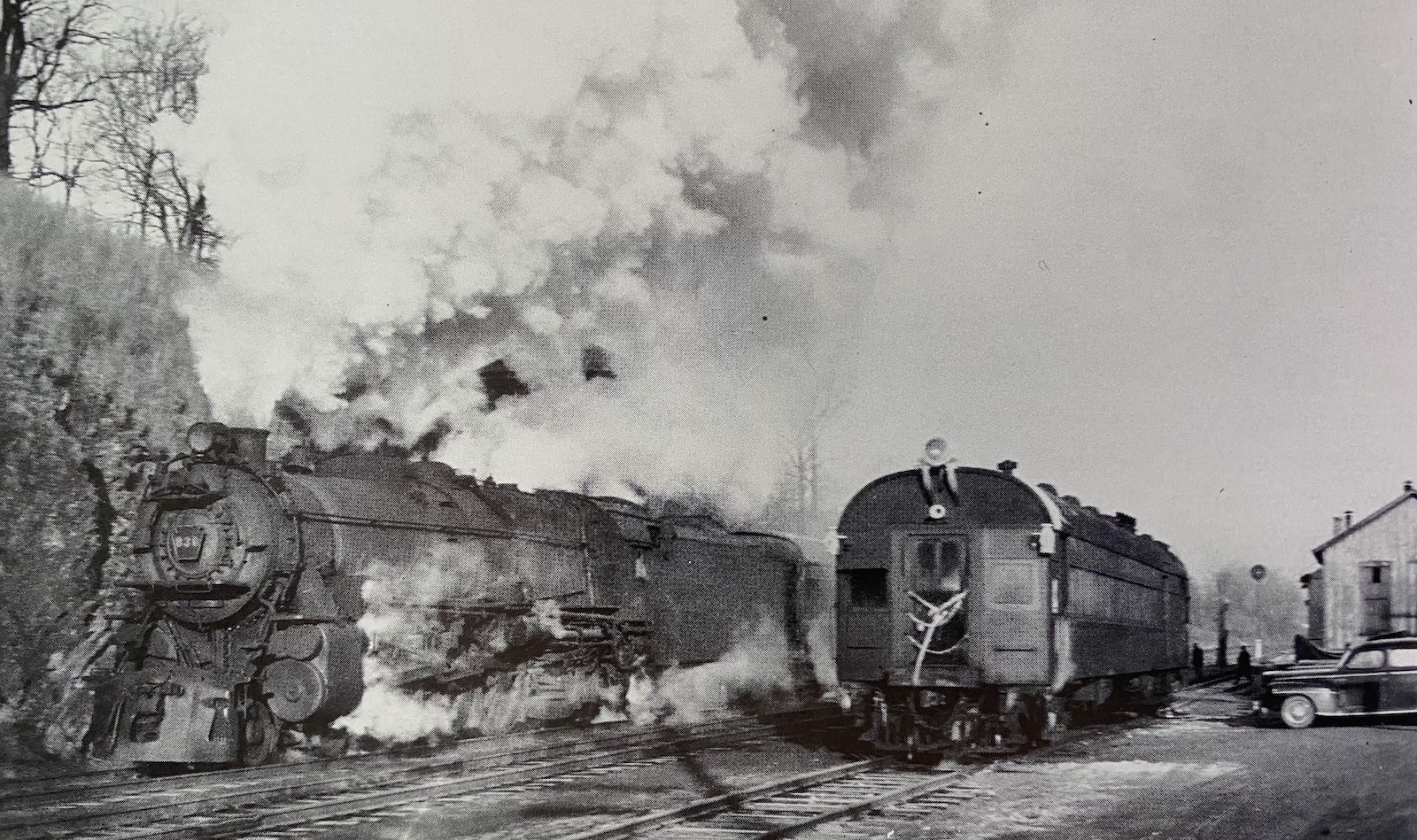 3
3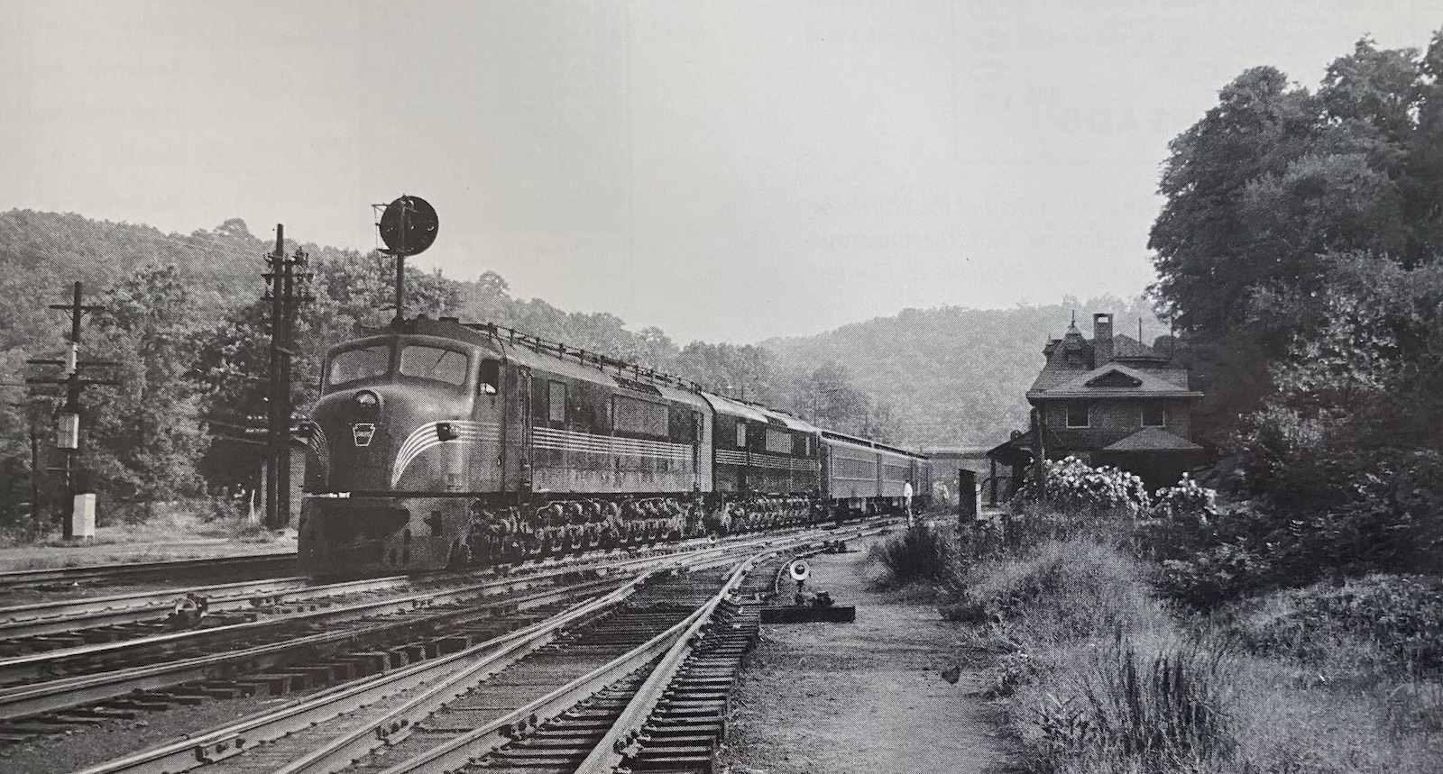 4
4These are the famous Pennsy "Centipedes".
 5
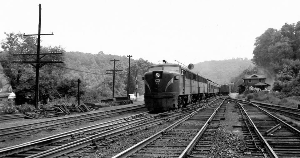
5Pennsy Alco's on a thru passenger train in Parkton, found on Pinterest, posted by Steven Allen
 6
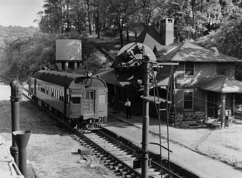
6Above from Facebook: Courtesy Gregory D. Pawelski, December 5th, 2022..... At one time, about 5 miles south of Freeland MD, PRR doodlebug No. 4666 ran on the Northern Central Rwy as "The Parkton Local". Here, she stands at the depot in Parkton MD, just before departing on its morning run down the double track Northern Central line to Baltimore on June 4, 1959. (Pennsylvania Railroad Collection)
 7
7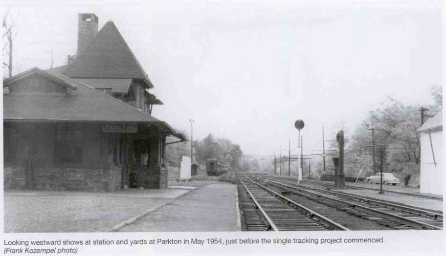 8
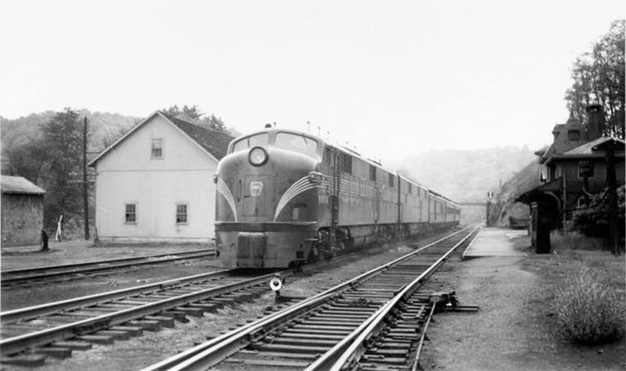
8Parkton 1954. Photo by Frank Kozempel, collection of Frank Wrabel. From an article appearing in the Spring 2025 issue of the Keystone, a publication of the Pennsylvania Railroad Technical and Historical Society.

https://en.wikipedia.org/wiki/Parkton,_Maryland
Greystone
Looking for pictures of the Parkton Local or station here..... have any to contribute?
Wiseburg Rd
Looking for pictures of the Parkton Local here..... have any to contribute?
Whitehall
Looking for pictures of the Parkton Local or station here..... have any to contribute?
Here are three pictures posted by Mark Jensen on the FB group for Abandoned Rails in 2024. Unknown when he took the pix.
I couldn't help myself, but Walthers puts out a model of a Whitehall station :-)
https://en.wikipedia.org/wiki/White_Hall,_Baltimore_County,_Maryland
Blue Mount
Looking for pictures of the Parkton Local or station here..... have any to contribute?
Monkton
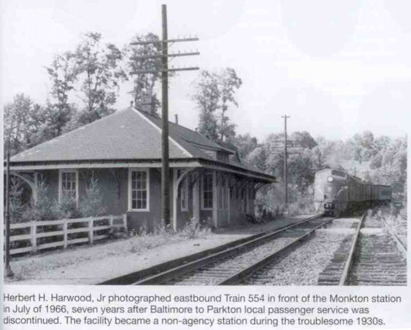 Frank Wrabel (4)
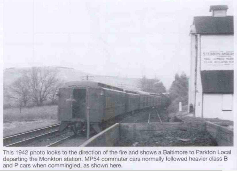 Frank Wrabel (4)
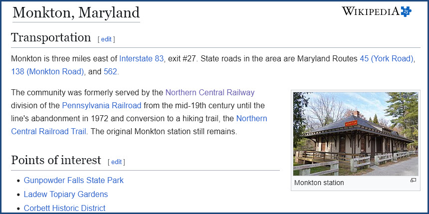
https://en.wikipedia.org/wiki/Monkton,_Maryland
Corbett
Looking for pictures of the Parkton Local or station here..... have any to contribute?
Glencoe
Looking for pictures of the Parkton Local here..... have any to contribute?
Sparks/Sparks Rd
Looking for pictures of the Parkton Local here..... have any to contribute?
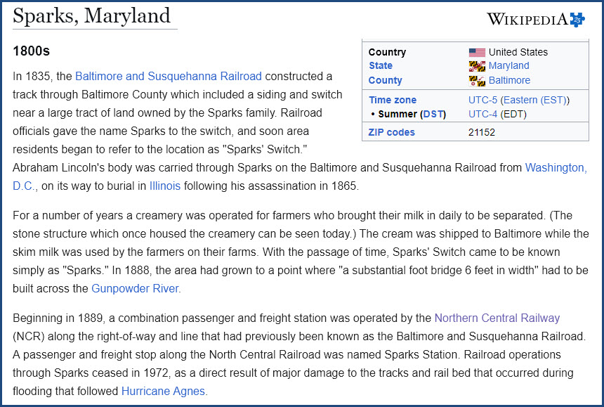
https://en.wikipedia.org/wiki/Sparks,_Maryland
Phoenix/Phoenix Rd
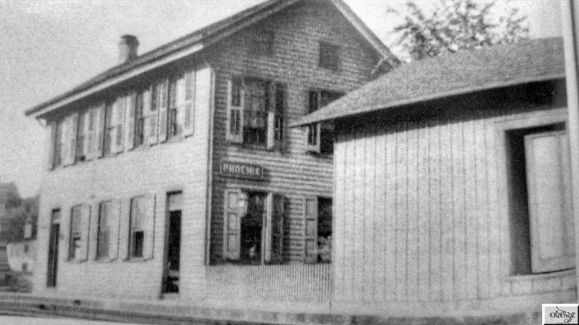 from a Kildruffs page
Ashland/Papermill Road
Looking for pictures of the Parkton Local here..... have any to contribute?
Cockeysville
See my Cockeysville page for complete coverage.
 found on the kilduffs page
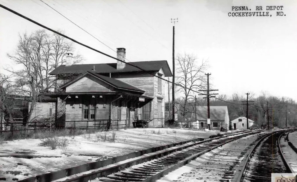 found on the kilduffs page
About the two pictures above, the one with an antenna pole is a later picture. The one without the pole is way earlier, but don't have a good sense for when the Pennsy put in radio repeaters along the Northern Central route.
https://en.wikipedia.org/wiki/Cockeysville,_Maryland
Texas
See my Texas page for more complete coverage.
Looking for pictures of the Parkton Local here..... have any to contribute?
The community of Texas is off Church Lane, off York Road nestled in between Timonium and Cockeysville. Baltimore County Fire Station #17 across from Target is the 'Texas' station. My ex father-in-law Lawrence Bode was born and raised on Church Lane near the NCR tracks and grade crossing, and my two daughters were baptized at St Joseph's Church. There may not be enough houses left on Church Lane to make a 'historic district', but there are still enough of them left for you to get an idea of what the street looked like 100 years ago!
Padonia
Looking for pictures of the Parkton Local or station here..... have any to contribute?
Timonium
See my Timonium page for complete coverage.
Looking for pictures of the Parkton Local here..... have any to contribute?
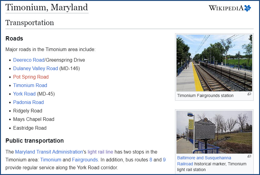
https://en.wikipedia.org/wiki/Timonium,_Maryland
Lutherville
See my Lutherville page for complete coverage.

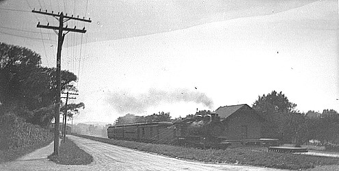
Photo by C.W.E. Treadwell, during WWI (1915-1917), uploaded by CGHowes to Wikipedia
 found on Pinterest, posted by ITW
https://en.wikipedia.org/wiki/Lutherville-Timonium,_Maryland
Riderwood
https://www.railfanguides.us/md/ruxton/index.htm I don't have a separate page for Riderwood, it is combined with Ruxton :-)
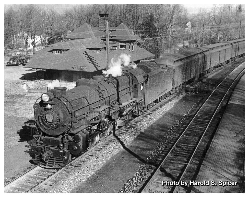
https://en.wikipedia.org/wiki/Ruxton-Riderwood,_Maryland
Ruxton
https://www.railfanguides.us/md/ruxton/index.htm
 1892, S. W. Wiley Jr
Lake
These two photographs come from a spot just north of where the station was located.
 Charles T. Mahan, ~1954
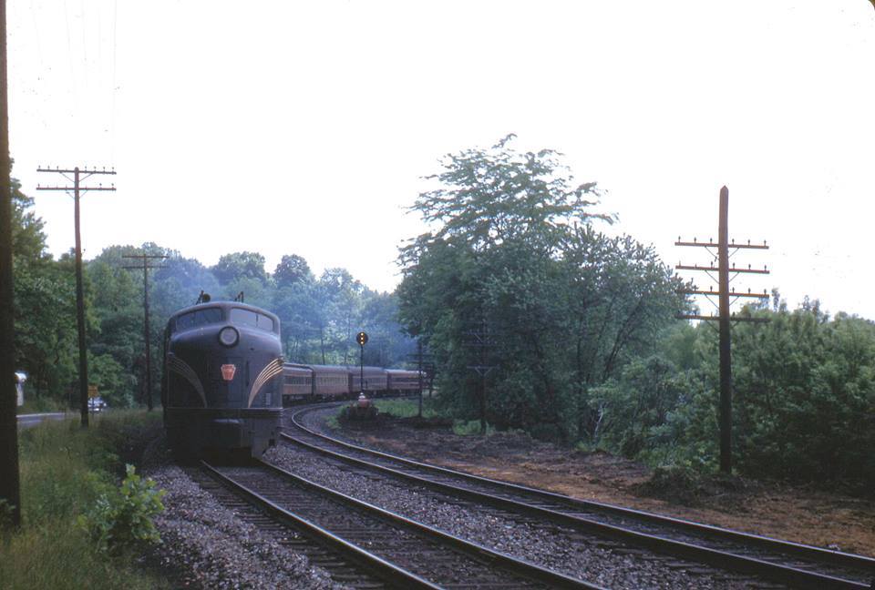 Warren E. Olt, ~1955
Passing by Hollins (Relay House) at the base of Lake Roland
If you visit here today, and look around, you have to wonder how they fit everything into that small "spot"!
Two tracks on the mainline, two tracks on the Greenspring Branch, a hotel, and a siding.....
Bare Hills
Looking for pictures of the Parkton Local or station here..... have any to contribute?
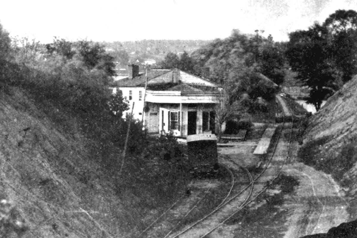
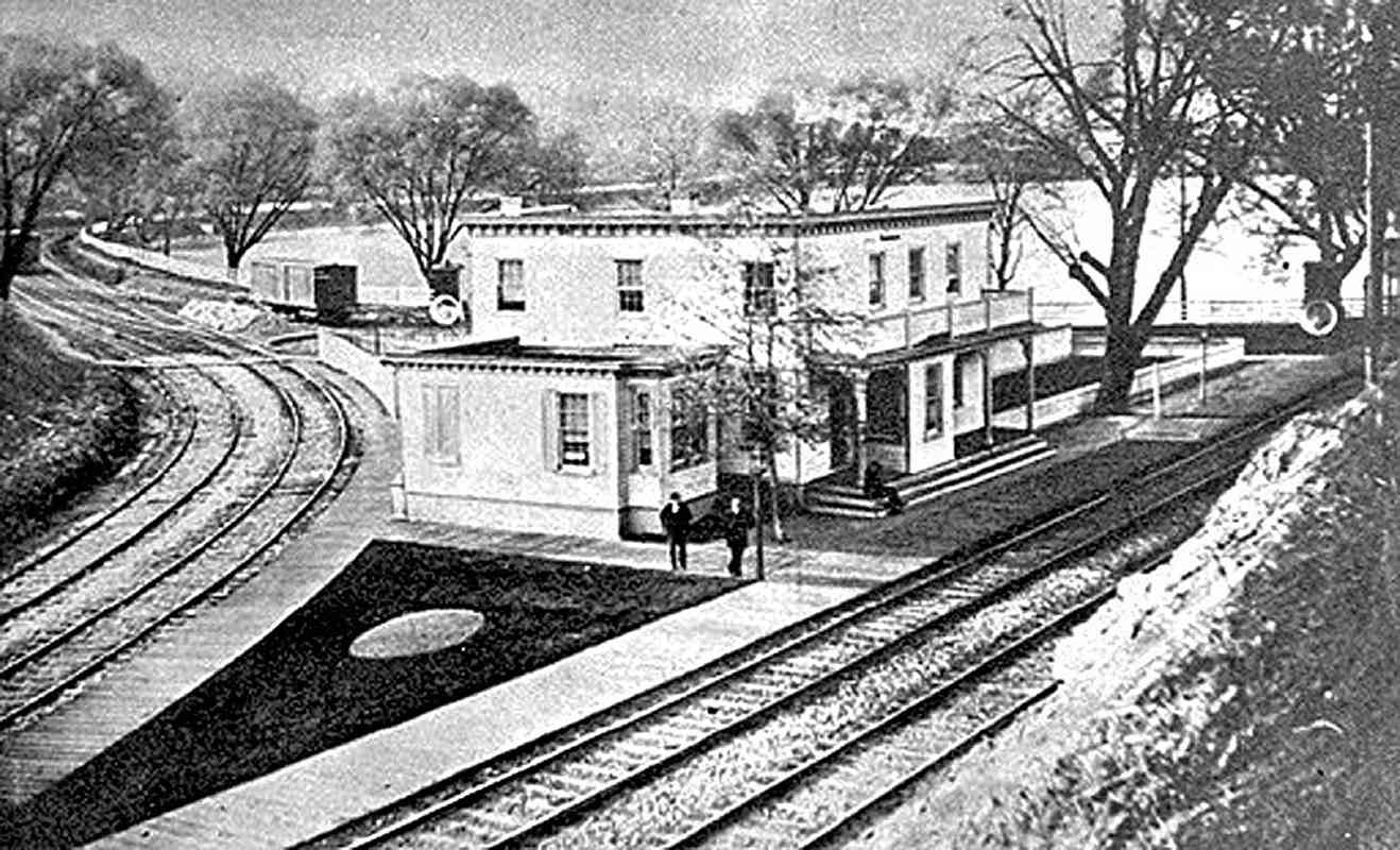
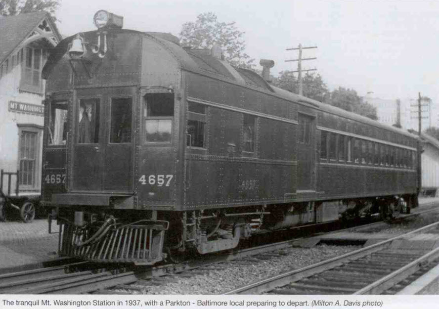
Mt Washington
Mt Washington in 1937 with a southbound Doodlebug getting ready to depart. Photo by Milton A. Davis, collection of Frank Wrabel. From an article appearing in the Spring 2025 issue of the Keystone, a publication of the Pennsylvania Railroad Technical and Historical Society. Second photo below from the same issue.
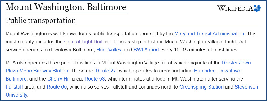
https://en.wikipedia.org/wiki/Mount_Washington,_Baltimore
Belvedere Ave
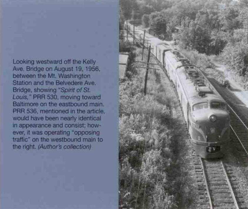
Although not a stop on the Parkton Local, I felt the urge to include this photo of Belvedere Ave going over the Northern Central, because Frank Wrabel thought it was interesting. I'm not sure when Belvedere Ave was replaced by Northern Parkway west of where it now ends, but Northern Parkway now goes over the tracks, and has ever since I've been driving in 1969. Interesting contrast. Wikipedia mentions the Belvedere Ave/Northern Pkwy change, but does not contain a date for any of it.
https://en.wikipedia.org/wiki/Northern_Parkway_(Baltimore)
 Sometime in the early 1900's.
 2023 Google Streetview.
Where Belvedere Ave ends at Northern Parkway and Bellona Ave, slightly west of York Road (near the Senator Theater).
If you take Bellona Ave in the direction of the blue arrow, you come to:
- The Riderwood Station in 3.89mi/6.27km.
- Where the Ruxton Station used to be in 3.11mi/5.00km.
- My house in 4.40mi/7.08km.
- Charles St in Woodbrook in 1.43/2.30km.
- Charles St by the the Beltway/695 in 4.79mi/7.71km.
- Lake Ave, where the old M&Pa depot is located about 1mi/1.6km west of Bellona.
Melvale
Looking for pictures of the Parkton Local or station here..... have any to contribute?
Woodberry
Looking for pictures of the Parkton Local or station here..... have any to contribute?
The Wikipedia page for the Light Rail station here actually gives credit to the former NCR station that used to be near here.
 found on Pinterest with no name attached
Penna Station
Looking for pictures of the Parkton Local or station here..... have any to contribute?
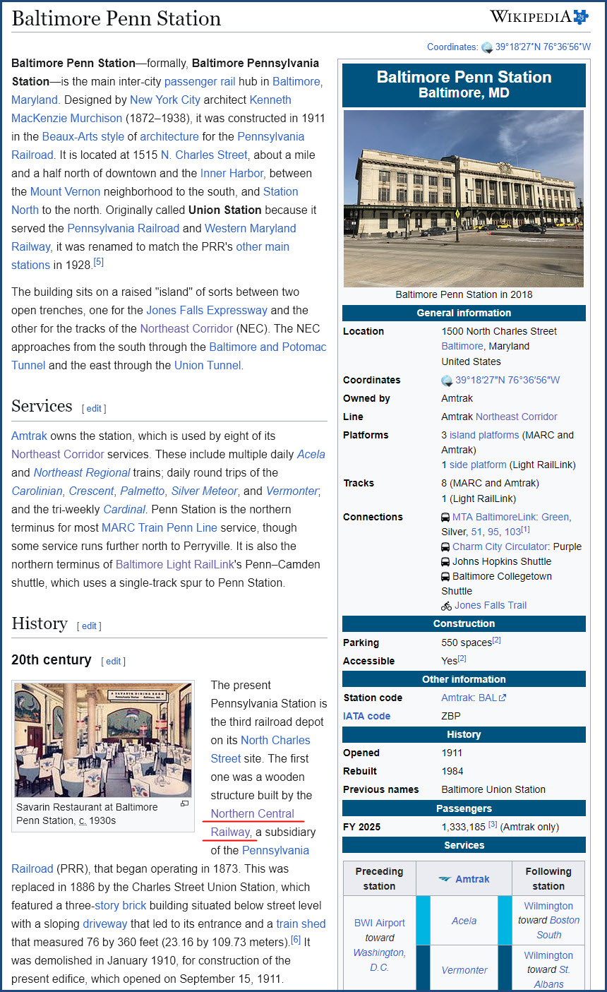
https://en.wikipedia.org/wiki/Baltimore_Penn_Station
Note: The above screen capture is a small part of the page, which is fairly large - visit the page is you want to read more about Penn Station.
Calvert Station
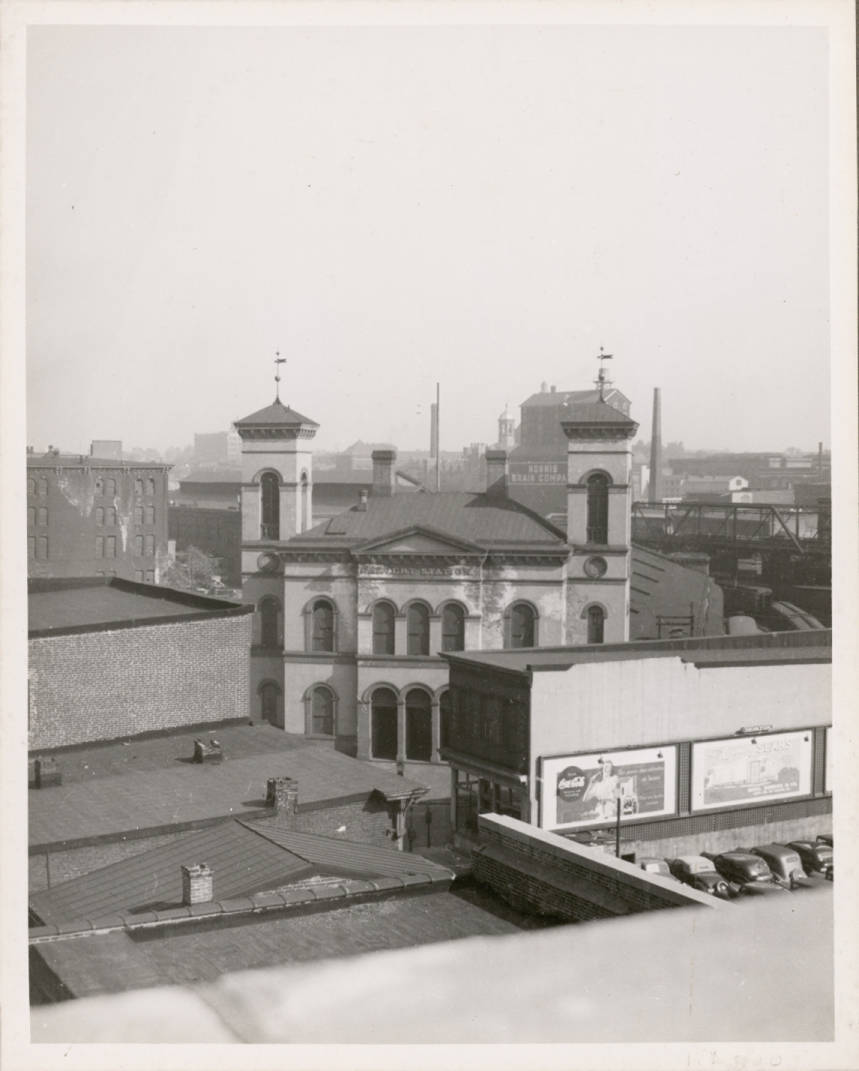
From the Library of Congress, comes these two pictures:
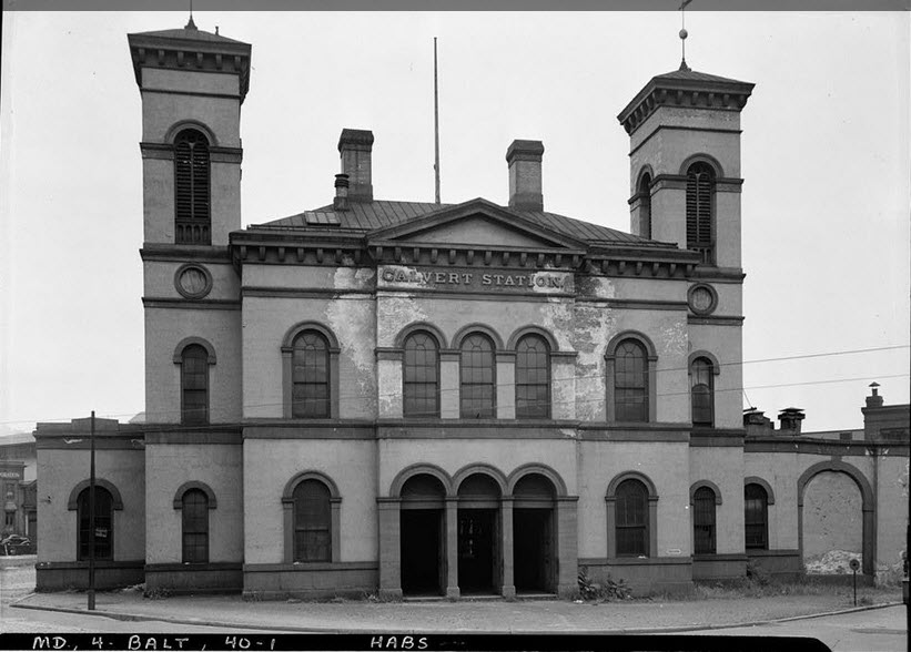
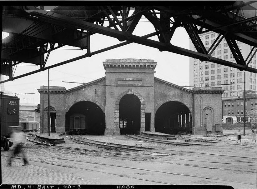
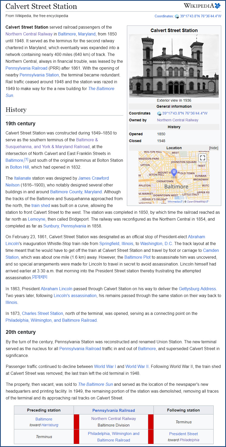
https://en.wikipedia.org/wiki/Calvert_Street_Station
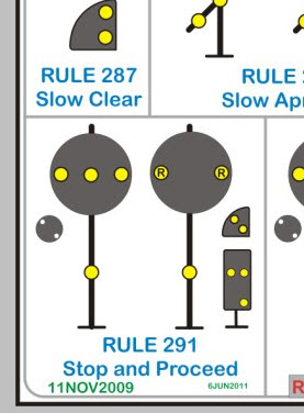
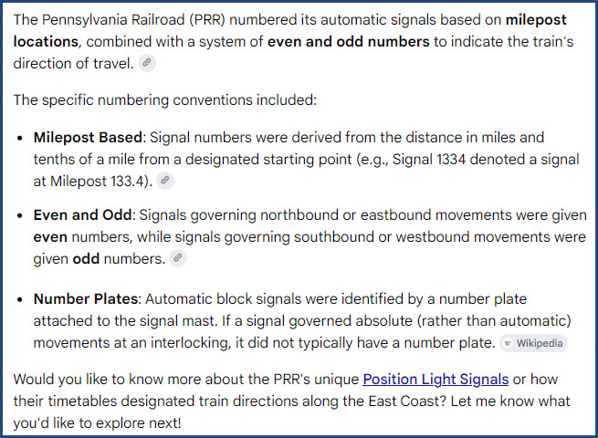
The Pennsylvania Railroad, starting around 1915, began switching over from -semaphore- signals, to a newly developed kind called -position light- signals, or PL's for short. If you want to learn more about PL signals, here is my page on them. Instead of using the familiar green/yellow/red lenses, the signals were designed to be readable in foggy conditions which seemed to be prevalent in the many valleys of Pennsylvania.
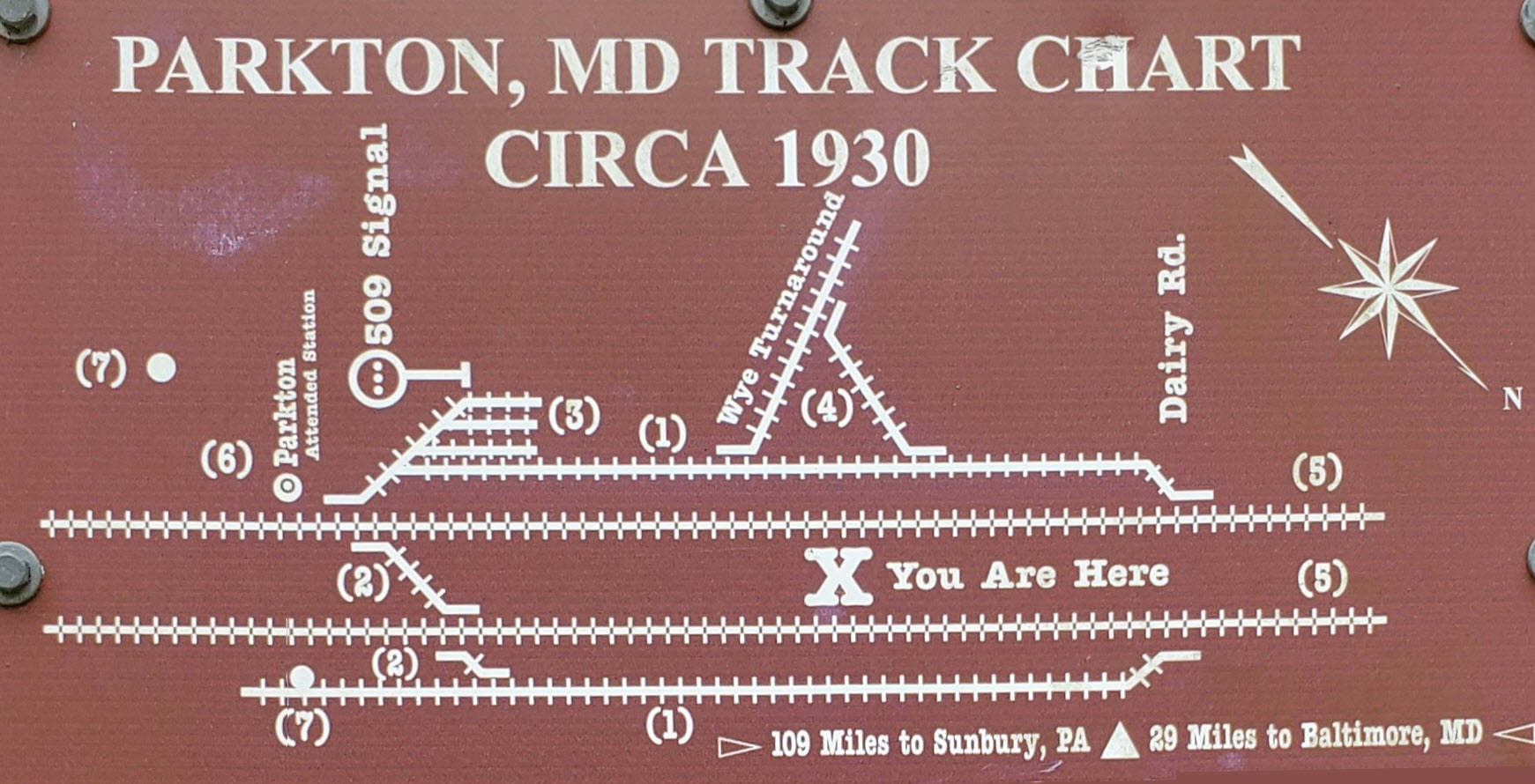
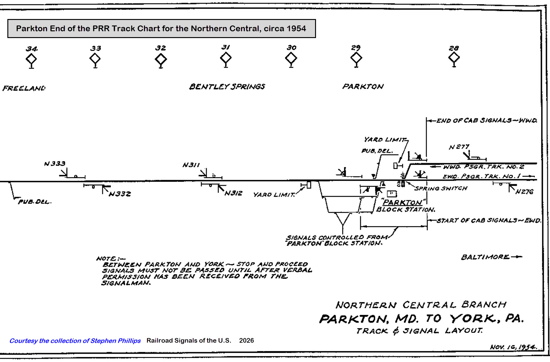
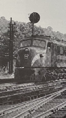
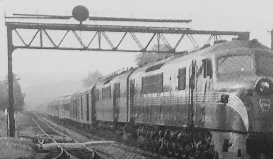
In the above pictures, we can see a northbound PL signal in shots 4, 5, and 6, with number six giving us the best view of the signal. In the track chart below, we can see that there were four signals in the immediate station area. Darn. Wish we had good pictures of them all!
I was finally able to get a track chart for the Northern Central from Parkton north to York, courtesy Stephen Phillips. It shows the track and signals circa 1954:
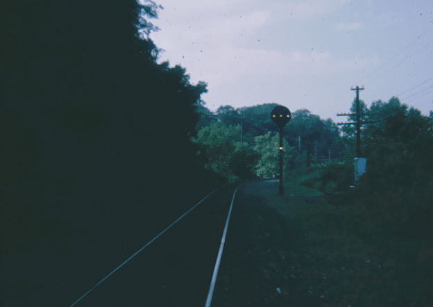
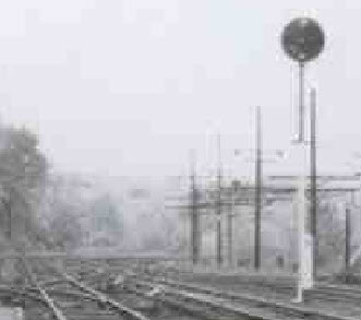
Here is a picture of a standard single-head mainline block signal. This picture I took, is one of the very few I managed to snap off while the line was in operation all the way to York and Harrisburg before Hurricane Agnes came along in 1972 and wiped out the line. This shot was taken around Northern Parkway in Baltimore City, back in the days when regular people like you and me could drive our cars along the R-O-W and not get thrown into jail :-). Even back then, like the light rail signals of today, the signals displayed STOP unless cleared by the dispatcher for a thru train. The insert from my PL chart shows that the single marker lamp below the main head indicates this is a stop and proceed signal, meaning once the train has stopped, it can proceed at restricted speed until it (the train) gets a more permissive signal or an obstruction is come across (and it needs to stop again).
So here we have snippets of the three photos with the NB PL signal - we can easily tell it is a standard high PL signal. This signal, not being an intermediate signal (such as signal N311, the next signal north), does not have a number plate on it, nor does it have a marker head below the main head. This is clearly shown on the track chart above.
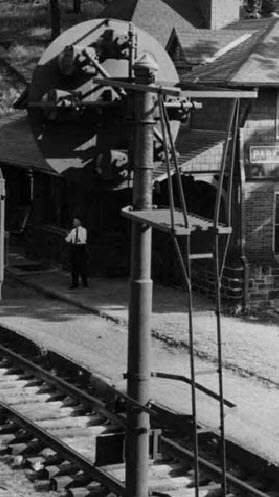
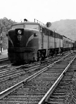
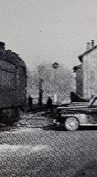
What is harder to tell from the photos, is the presence of a SB signal. But in two of the pictures, we see a small round "thing" on a pole, on the south side of the station. This probably the southbound signal. Anyone know of additional pictures from in and around Parkton? Too bad we don't have a picture of a Parkton Local coming into the station, that would show off the SB signal really well. All the other pictures of NB trains are of thru trains heading to Harrisburg.
Finally, after searching Bing for pictures, I came across a picture (#7 above) that was taken in the later years, and shows a much better picture of the SB signal, so much so, that you can see it displaying a CLEAR SIGNAL.
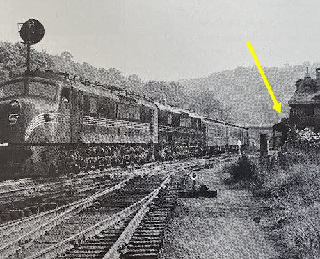
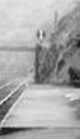
One of the few pictures of SB trains I have come across is from Charles T. Mahan (in 1949), and shows the southbound signal as trains approached Parkton. The Pennsy did not rely on "doll posts" (never seen one) and cantilevered signals very much (ZOO Interlocking is one of the few exceptions), so we have a full signal bridge spanning all of the tracks at this location.
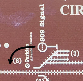
In the track schematic the park/trail system erected, they show a signal, 509, but it is located at the switch for the "third" siding track, and not on the mainline. There is no reason for there to be a signal there. A yard signal, if there was one, would NOT be numbered, and it would be a dwarf signal. It should be corrected and moved on the park display. NOTE: I noticed on the sign they have on the signal in Monkton, that they refer to the signal as a '509', given that, I think the Park People think that the 509 is a signal type, which it is NOT.
Always on the lookout for additional information, I searched Google's AI for a simple explanation of the signal numbering system, and it is shown below. However, if you want to learn more about Pennsy PL signal's (not that it is a link), don't use their link to that page, because it does not explain anything about Pennsy PL signals, it is a page for signal basics, which covers ALL signals. It's another one of my pages, that's how I know.....
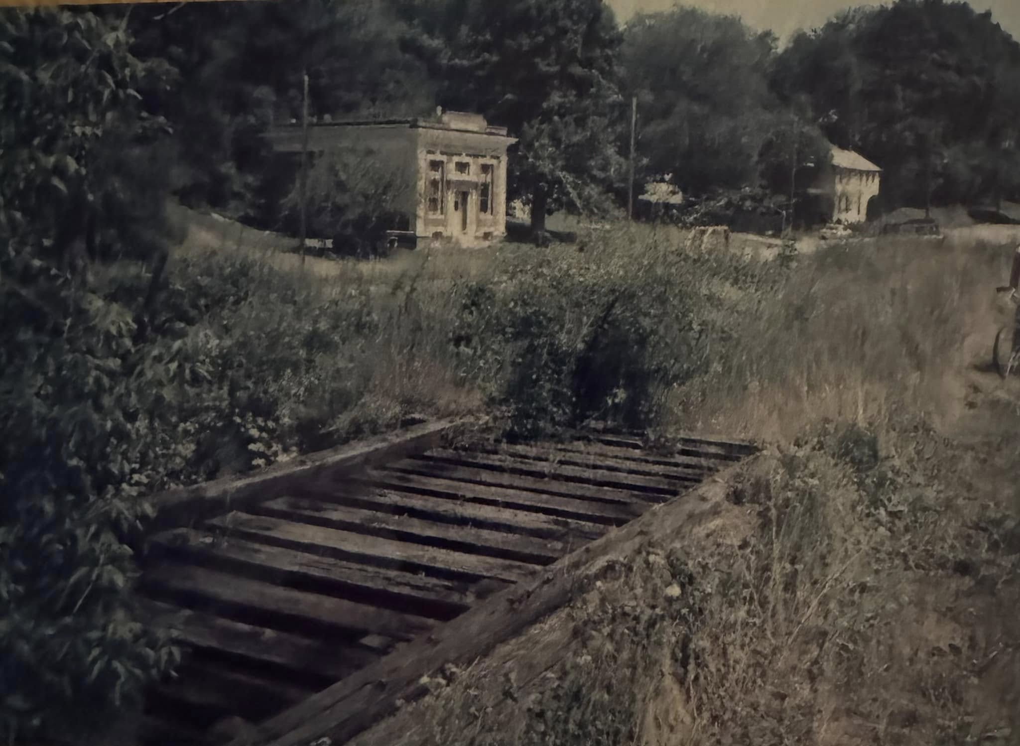
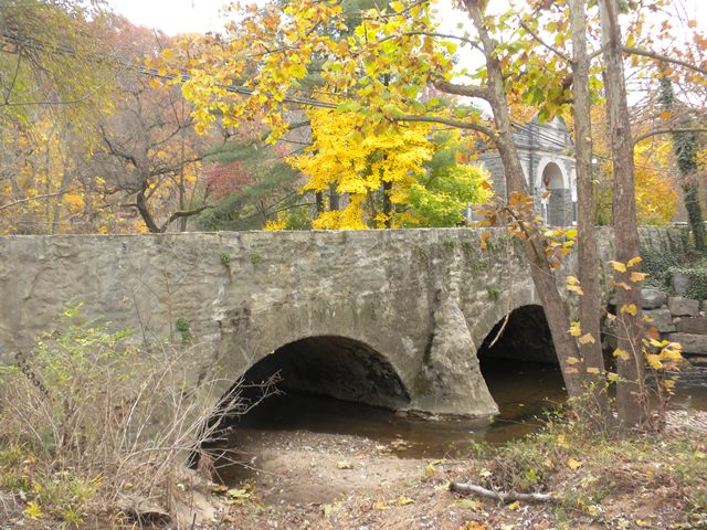
the Frederick Road Bridge
 Bob Dover/November 2, 2013
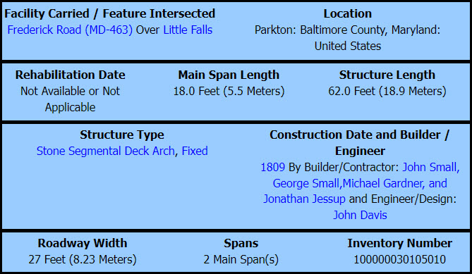
Notes from Historic Bridges.org:
The bridge still carries traffic, but the amount of traffic is very limited. In the mid-1800s, the Northern Central Railroad (NCRR) between Baltimore and York was built, and passed directly through the center of Parkton a few hundred feet west of the bridge. The bridge and the center of Parkton were then bypassed in 1929 with a newer, higher bridge carrying York Road (Maryland Route 45) over the creek a few hundred feet downstream of the Stone Arch. In the 1970s, the NCRR was closed. In the early 1990s, the railroad right-of-way was incorporated into Gunpowder Falls State Park, and was turned into a bicycle rail trail (once called the NCRR Trail, now called the Torrey C. Brown Trail). Old York Road was closed on either side of the rail trail, leaving the bridge on a short dead end road, about a quarter mile long, between York Road and the rail trail. There are two houses and a small parking lot (space for about 10 cars) for the rail trail on this dead end stretch between the bridge and the trail. So although the bridge does not carry through-traffic, it does carry cars to the two houses and the parking lot. One of the two houses is very interesting � it is in a 100-plus year old stone bank building, right at the end of the bridge.
Construction/Description: The bridge is a small stone arch bridge, consisting of two arches. The length of the bridge is about 50 feet, the deck is only about 10 feet above creek level, and the bridge is only about 15 feet wide (one lane of traffic). The bridge is made of mostly unshaped local stone, although the arches are outlined with flat stones placed radially around the arch.
Even though there is no documentation at the bridge itself, the status of the bridge as the oldest bridge in the state is well-documented in several state publications. Therefore, there is little risk of the bridge being removed accidentally without an understanding of its significance.
HistoricBridges.org Discussion: Engineer is assumed, per Historic Bridge Inventory. Also assumed to be the oldest stone arch bridge in the state. The bridge appears to have been altered with gunnite, shotcrete, or excessive mortar by previous repairs. This has visually obscured the stone to some extent. The bridge is highly significant in the state context as the oldest bridge of its kind and perhaps of any kind in the state. It is also noteworthy since it was built for the Baltimore and York-town Turnpike.
1827, August 15 - George Winchester assigned to survey potential traffic routes by Baltimore businessmen. (1)
1828, February 13 - The Baltimore & Susquehanna Railroad (B&S) was incorporated.
1829 - Construction of the B&S started (2).
1831 - Track completed to Roland Run/Relay House ("bottom" of Lake Roland), later called Hollins.
1831, July 4 - the B&S celebrates the opening of its train service, carrying passengers pulled by horses to the Roland Run.
1832 - Track completed to Timonium. (1)
1832 - Track completed to Owings Mills via the Greenspring Branch from Relay House/Hollins.
1832 - First steam locomotive, the Herald, arrives from England, immediately put into service. (1)
1832, March 14 - Formation of the York & Maryland Line RR (to build the Pennsylvania section of the B&S). (2)
1834 - Track completed to Texas. (1)
1835 - Track completed to Cockeysville. (1)
1837 - Track completed to Parkton. (1)
1837 - Track completed to the MD/PA state line. (2)
1837? - Formation of the York & Maryland Line RR (Frank Wrabel date).
*1837? - First thru train between Baltimore and York.
*1838 - Track completed to York.
1854 - First engine house in Parkton - MAYBE? (1)
1854 - Margaret Parke started selling lots in the area, inherited from her father James Calder. (1)
1854 - The B&S merged with the Y&ML and the Wrightsville, York, and Gettysburg RR to form the Northern Central RR.
1855-1859 - Replacement of more than 75 bridges. (2)
1858? - Track completed to Sunbury PA.
1858 - Completion of wood and strap-iron rails on the main line replacement with rolled-iron “T” rails. Several more years for sidings and yards. (2)
1859 - First tollgate erected on York Rd/York Turnpike. (1)
1861 - The Pennsylvania RR gained a controlling interest in the NCR.
1861 - Soon after the PRR gained controlling interest, it started the Parkton Local. (3)
1861, February 21 - President-elect Lincoln's inaugural train rerouted off the NCR thru Philly, because of unruly southern sympathizers. (1)
1861 - NCR management started the massive task of rebuilding the track structure and installing double track lines (shoulda waited, huh? :-) (1)
1861, April 20 - Bridges at Melvale, Relay House, and Cockeysville burned, along with telegraph lines cut. (1)
1861, April 20+ - Bridges further north at Mile Run, Owl Brook, Bee Tree, and Little Falls burned to prevent northern troops from using the railroad. (1)
1861, May 13 - Temporary bridges built to replace those burned in April.
1861, June - 33 bridges burned as part of the Civil War, all rebuilt by June 29th!
1862, September - 140th Pennsylvania Infantry established their camp in Parkton, initially the site of several small guard camps.
1862, December - 140th Pennsylvania Infantry leaves Parkton.
1863, May - Permanent bridges rebuilt.
1863, November 18 - President Lincoln journeyed over the war-torn NCR on 1863 on his way north to Gettysburg. (1)
1864, July 9 - The Cockeysville and Gunpowder bridges were consumed by fire n the Johnson-Gilmor raid.
1864 - The line was double-tracked at Parkton. (1)
1865, April 21 - President Lincoln's funeral train traverses the NCR. (1)
1868 - The crude, single track main line was finally double tracked for traffic eastward and westward (railroad timetable direction). (1)
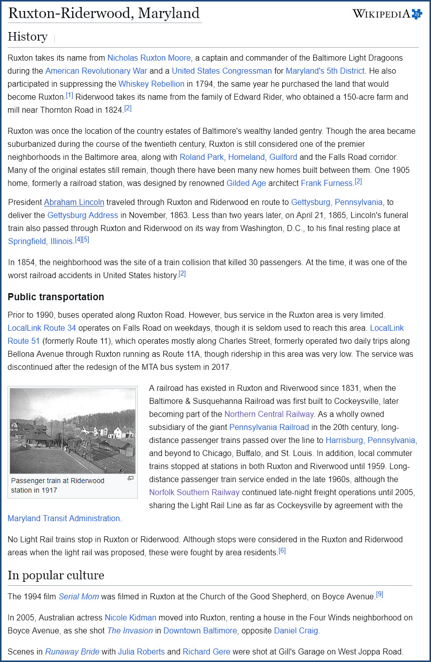
1903 - The noted Philadelphia architectural firm of Furness and Evans completed an intriguing design for a station. (1)
1903 - New station built in Parkton (1) and opened. (3)
1903 - The 1882 passenger station was rebuilt as a freight office for the PRR and the Adams Express Company, and later the REA. (1)
1916, May 8th - the Northern Central, Greenspring Branch, and the WM were used as a bypass route while work was being done on B&P Tunnel.
1932, February 13 - Fire in Monkton caused bypassing locomotive. (4)
1933 - Passenger/commuter service ended on the Greenspring Branch.
1949 - Calvert Station razed by fire to make room for Sunpapers Building. (3)
1954, November 9 - General Order #706 issued, accompanied by new track chart and signal plan went into effect at 11am. (4)
1954 - GO #706 also marks the completion of the last portion of the single track project on the NCR between MP 47.2 (York) and MP 47.0 (Smyser PA). (4)
1958 – Parkton was listed as the only station in Baltimore County that had train service to Baltimore according to the Kilduffs page.
1959, June - End of the Parkton Local.
1963, October 14 - The Parkton station is burned down as practice for local volunteer fire company. (3)
1968, February 1 - Pennsylvania Railroad becomes the Penn Central RR after merger with the New York Central and others.
1974, June 12 - Cockeysville Station demolished (HSBC photo files P002652))
1976, April 1 - Penn Central becomes Conrail after the merger with most north east railroads.
1992, April 2 - Light Rail opens their line, with the north end at Timonium.
1997, September 9 - Extension from Timonium to Hunt Valley opens - single track north of the Gilroy Road station.
1999, June 1 - Conrail splits assets between CSX and Norfolk Southern, the Northern Central becomes NS "territory".
2005 - Light Rail double tracking project began on the north end of the system, the Northern Central.
2005 - Last Norfolk Southern freight on the Northern Central.
* Dates in Frank Wrabel's account of the Northern Central that conflict with each other.
Most of this history, except for modern dates, comes from Frank Wrabel's history page.
(1) HSBC - Historical Society of Baltimore County
(2) Wikipedia
(3) NCR Trail / York Heritage Trail Facebook page
(4) - PRRTHS Spring 2025 issue, article by Frank Wrabel
Courtesy USGS, click here for their index page.
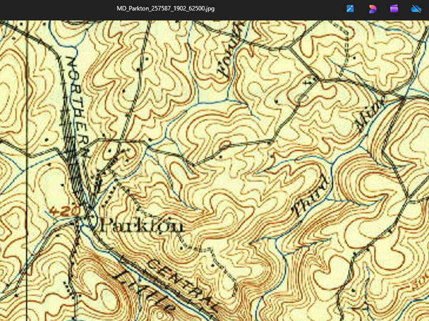 1902
1902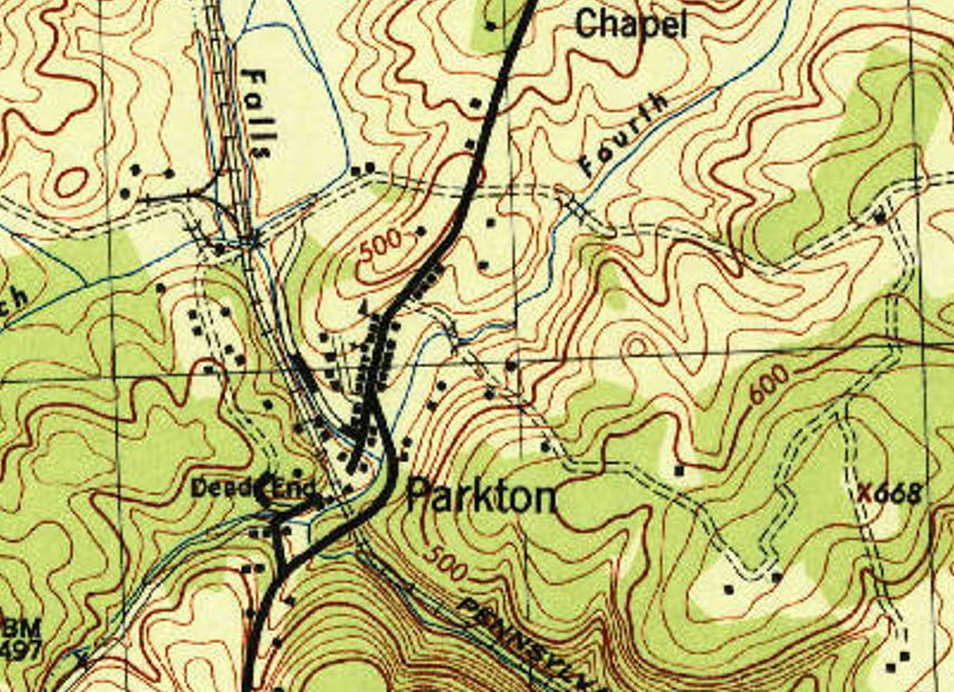 1953
1953Disclaimers:
New format 10/26/23: Please check out my disclaimer page for my standard dribble and contact info here
RAILFAN GUIDES HOME
RAILROAD SIGNALS HOME
NEW 05/27/2026, MAY28/29/30/31/2026, JUN16/17/2026 JUN01/02/03/04/05/06/12/16/22/23/24/25/2026
Last Modified 26-Jun-2026