In General
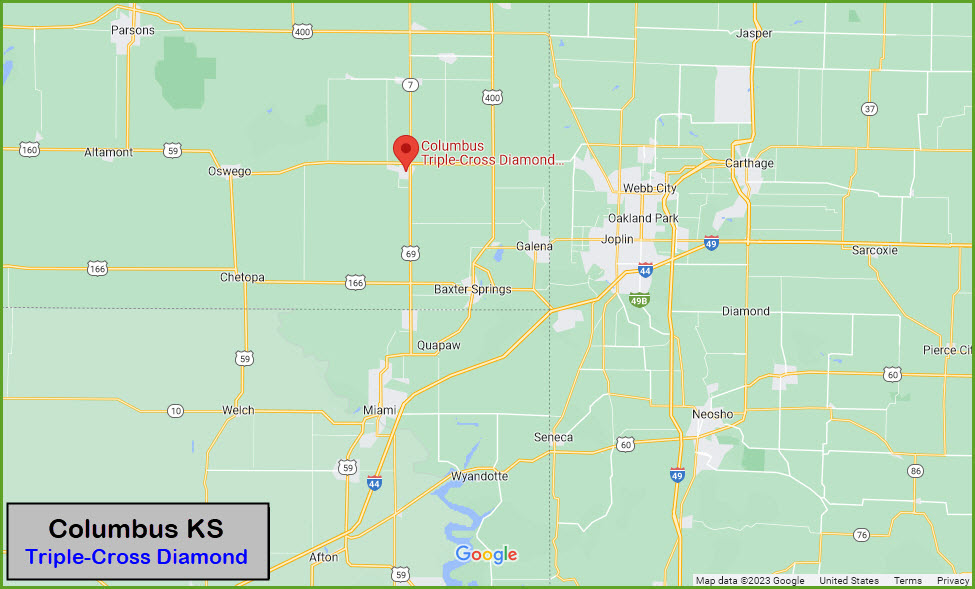
Getting Here
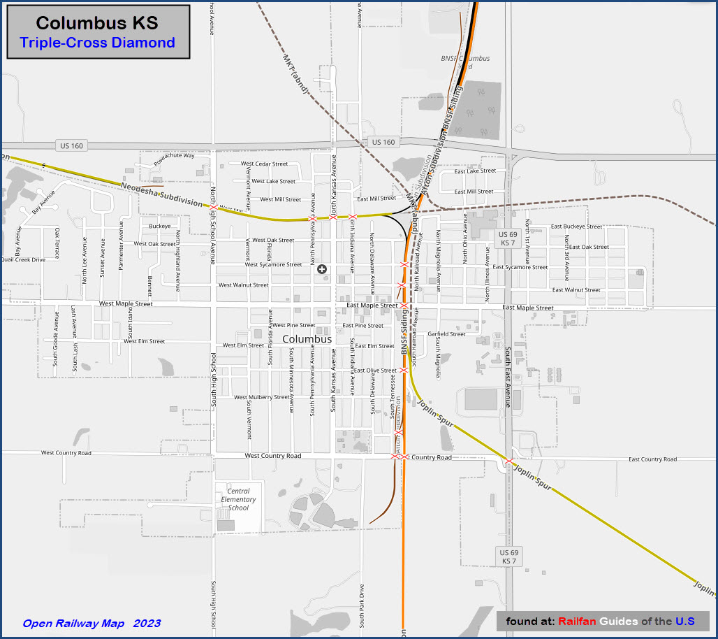
Map
Pictures
Signals
Fire & Police
Postcards
Floobydust
USGS Maps
RAILROAD SIGNALS HOME
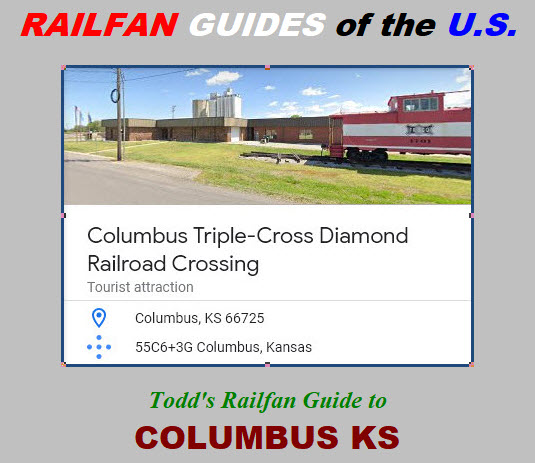
Location / Name:
Columbus KS, Cherokee County (county seat)
What's Here:
Former triple crossing diamond
Data:
GPS Coordinates: 37.17020, -94.83873
Address: 100 S Tennessee Ave, Columbus KS 66725 (address of the Columbia Museum)
Phone A/C: 620, and 6 exchanges: 284, 389, 429, 597, 674, 762
ZIP: 66725
2020 Census: 2,929
Access by train/transit:
None
Geography:
Flat
The Scoop:
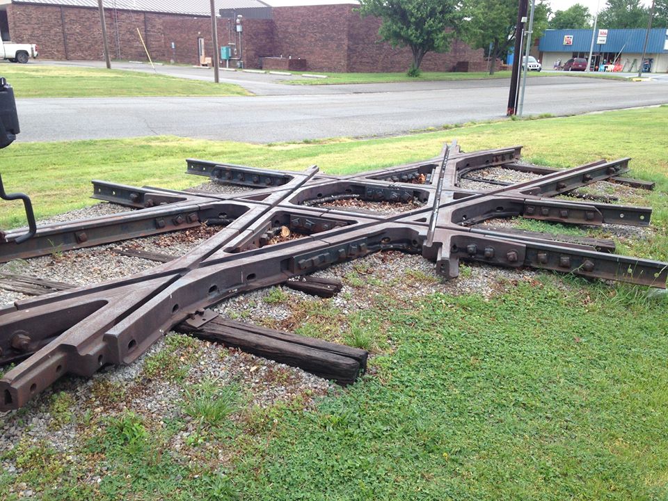
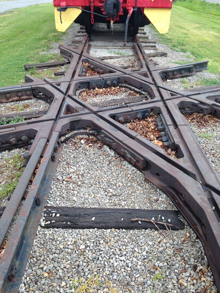
This is the picture that started this page. I came across it on Pinterest. The picture was a little lopsided, so I put it thru Snagit to cleanup the skew-ness from taking a picture, of a picture, off center.
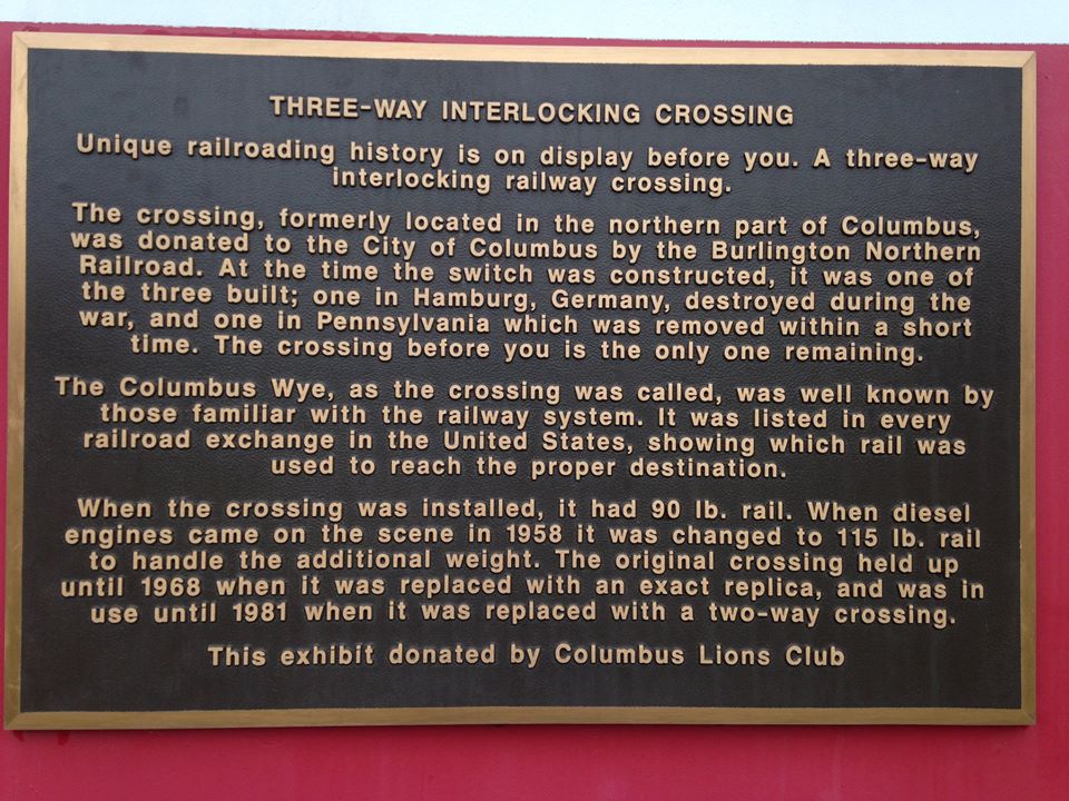
This is called a triple diamond, but not like the one we all know and love in Fostoria OH. This triple diamond has three tracks all crossing at one time within the same diamond. This diamond used to be located in Columbia between two tracks of the Frisco, and one for the MKT.
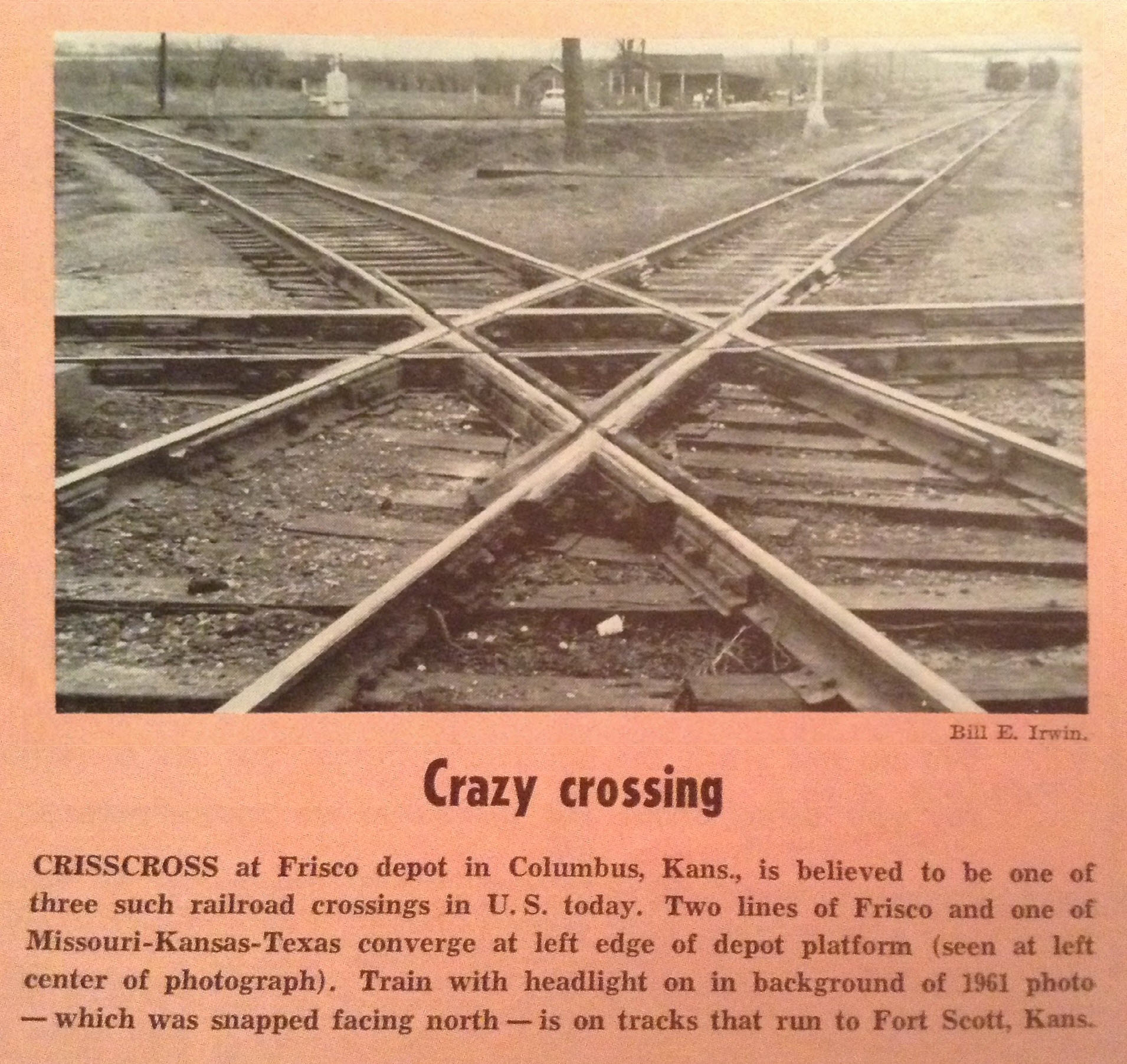
According to the historic plaque, the diamond was originally laid with 90 pound rail. When diesels appeared on the scene in 1958, they rebuilt the diamond with 115 pound rail. That rail lasted 10 years and the diamond was rebuilt - the second incarnation lasted until 1981 when it was replaced with a standard diamond due to the KCS line getting abandoned. When it was replaced, BNSF donated the triple-diamond to the city.
The three-way diamond is supposedly only one of three built. One of the other two was in Hamburg Germany and was destroyed in one of the wars. The third diamond was somewhere in Pennsylvania, but apparently didn't last very long. Information other than what is provided by on the plaque seems to be almost non-existent after searching for a couple of days.... maybe I'm just not looking in the right spots :-).
Acknowledgements:
Bruce Feld
Denver Todd
Google Maps
Open Railway Map
Wikipedia
Websites and other additional information sources of interest for the area:
http://towns-and-nature.blogspot.com/2020/03/columbus-ks-triple-cross-diamond-and-8.html
https://www.hmdb.org/m.asp?m=11593
https://www.trainorders.com/discussion/read.php?11,1778600
https://www.hmdb.org/m.asp?m=169428
Coming in from the west, it looks like US 160 may be your best bet.
I-44 is about 17 miles southeast, as the crow flies, I would use your GPS to get here. Same thing goes for I-49, it is about 22 miles east over in Webb City.


.jpg)

.jpg)


GPS Coordinates:
The
GPS Coordinates:
The
![]() Xxx
Xxx
The
![]() Xxx
Xxx
The
![]() Xxx
Xxx
The
Did U Know?
None for now......
Courtesy USGS, click here for their index page.
Disclaimers:
I love trains, and I love signals. I am not an expert. My webpages reflect what I find on the topic of the page. This is something I have fun with while trying to help others.
Please Note: Since the main focus of my two websites is railroad signals, the railfan guides are oriented towards the signal fan being able to locate them. For those of you into the modeling aspect of our hobby, my indexa page has a list of almost everything railroad oriented I can think of to provide you with at least a few pictures to help you detail your pike.
If this is a railfan page, every effort has been made to make sure that the information contained on this map and in this railfan guide is correct. Once in a while, an error may creep in :-)
My philosophy: Pictures and maps are worth a thousand words, especially for railfanning. Text descriptions only get you so far, especially if you get lost or disoriented. Take along good maps.... a GPS is OK to get somewhere, but maps are still better if you get lost! I belong to AAA, which allows you to get local maps for free when you visit the local branches. ADC puts out a nice series of county maps for the Washington DC area, but their state maps do not have the railroads on them. If you can find em, I like the National Geographic map book of the U.S..... good, clear, and concise graphics, and they do a really good job of showing you where tourist type attractions are, although they too lack the railroads. Other notes about specific areas will show up on that page if known.
Aerial shots were taken from either Google or Bing Maps as noted. Screen captures are made with Snagit, a Techsmith product... a great tool if you have never used it!
By the way, floobydust is a term I picked up 30-40 years ago from a National Semiconductor data book, and means miscellaneous and/or other stuff.
Pictures and additional information is always needed if anyone feels inclined to take 'em, send 'em, and share 'em, or if you have something to add or correct.... credit is always given! Please be NICE!!! Contact info is here
Beware: If used as a source, ANYTHING from Wikipedia must be treated as being possibly inaccurate, wrong, or not true.
SEPTA HOMEPAGE
RAILFAN GUIDES HOME
RAILROAD SIGNALS HOME
NEW 06/22/2023
Last Modified 23-Jun-2023