Maps
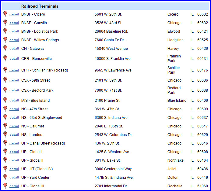
The Yards - Alphabetical Listing
the Yards of Chicago
Floobydust
RAILFAN GUIDES HOME
RAILROAD SIGNALS HOME
Yards dot the Chicago landscape all over the place..... Take your pick! All of the trains heading into and out of Chicago need someplace to go or start out of. There are over 40 yards currently in and around Chicago, and in the past, there were well over 70!
This is a VERY large page, as there are 81 yards listed. Please be patient. If you are using a dial up connection, go have lunch or dinner :-)
Notes about locations:
Distances and directions are from the middle of "the loop".
Just keep in mind while you're running around railfanning, that the railroads, especially today, really frown on trespassing onto their property for picture taking. When you can find a good vantage point, make sure you have a really good camera with a really good telephoto lens. I use the "cheap" Canon series of "point and shoot" cameras, like the SX30IS, with pretty good telephoto capabilities. Not good enough for really, really serious photography, but almost every picture you will find on my two websites is taken with it. Even back in 1972, the railroad police chased me out of a number of yards when we were in town for EMD's 50th anniversary celebration, when in most other places, they really didn't care :-)
Pictures and additional information is always needed if anyone feels inclined to take 'em, send 'em, and share 'em, or if you have something to add or correct.... credit is always given! Contact info is here
Acknowledgements:
Denver Todd
Tim Kaczocha
Clifton L.
Some additional resources:
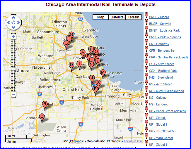
http://www.intermodalofchicago.org/terminals_map.cfm
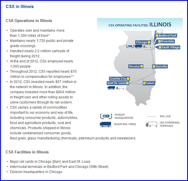
http://www.csx.com/index.cfm/about-csx/company-overview/state-fact-sheets/illinois/
http://trainweb.com/slides/sscc.htm
http://www.dhke.com/CRJ/station.html nice page on Chicago stations
The Chicago Yards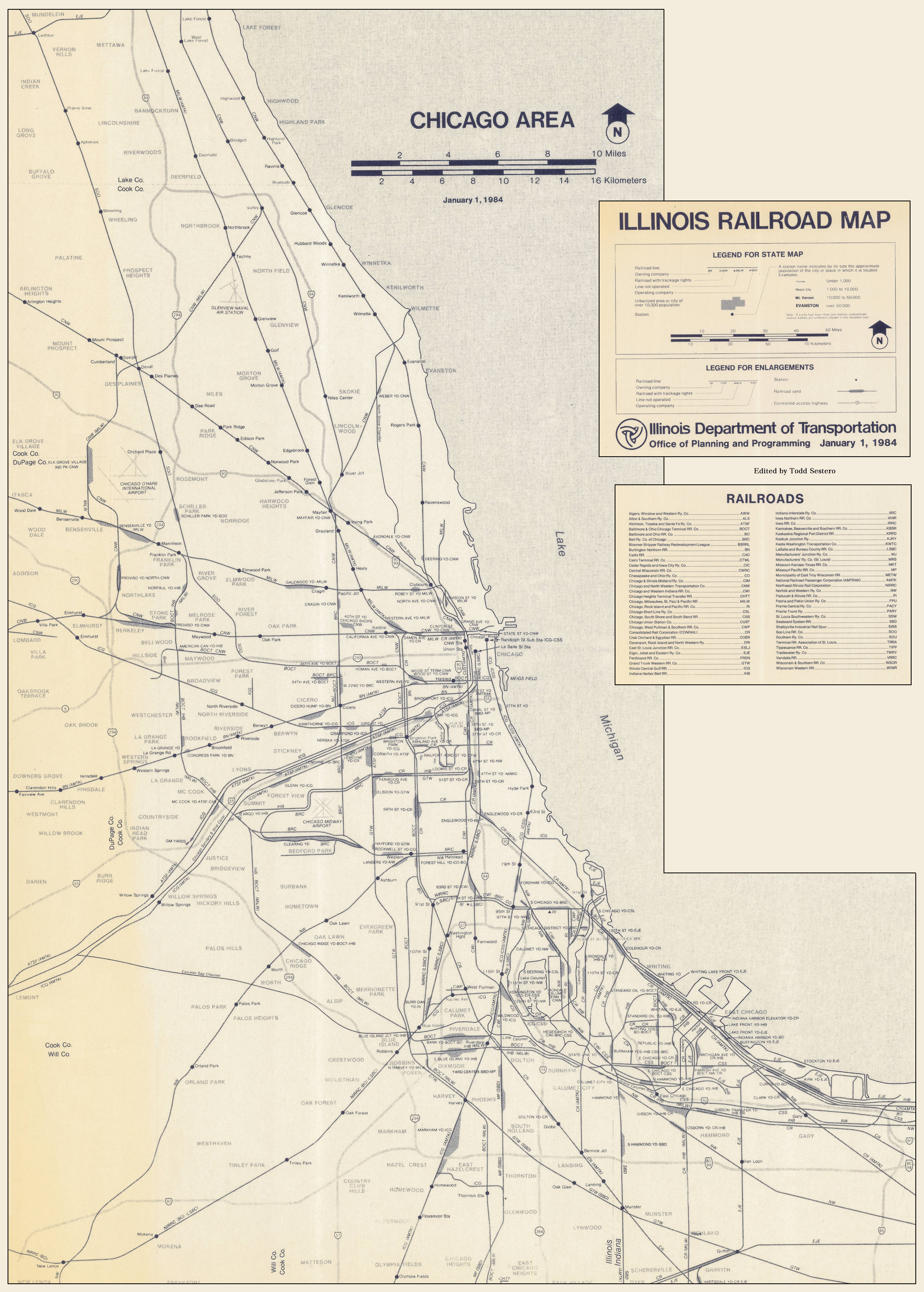
click on the above map for a much larger version, it's around a 3.5m JPEG
Alphabetical Listing
Here is a list of the yards in and around Chicago, a quick highlight of them is below, there's 82 yards listed here....
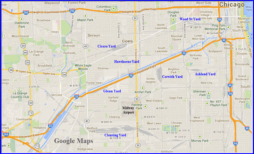
The maps below the list illustrate where they are in relationship to downtown.
14th St Yard
14th St Coach Yard
18th St Yard
21st St Yard
22nd St Yard
27th St Yard (gone)
33rd St Yard
35th St Yard
40th St Yard
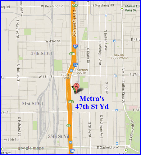
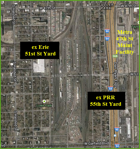
47th St Yard
47th St Yard - Metra
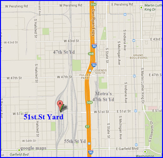
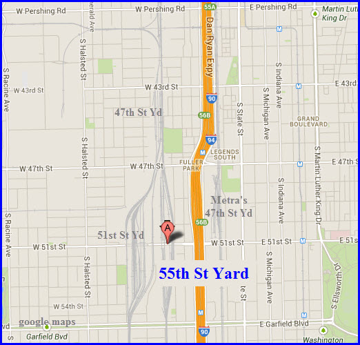
51st St Yard
55th St Yard (gone)
59th St Yard (gone)
83rd St Yard (gone)
87th St Yard (gone)
97th St Yard
Argo Yard
Ashland Ave Yard
Barr Yard
Bedford Park Yard
Blue Island Yard
Brighton Park Yard
Burnham Yard
Burr Oak Yard
California Ave Yard
Calumet Yard
Canal St Yard - CWI
Canal St Yard - UP
Cico Yard
Chicago Ave Yard
Chicago Transfer Yard
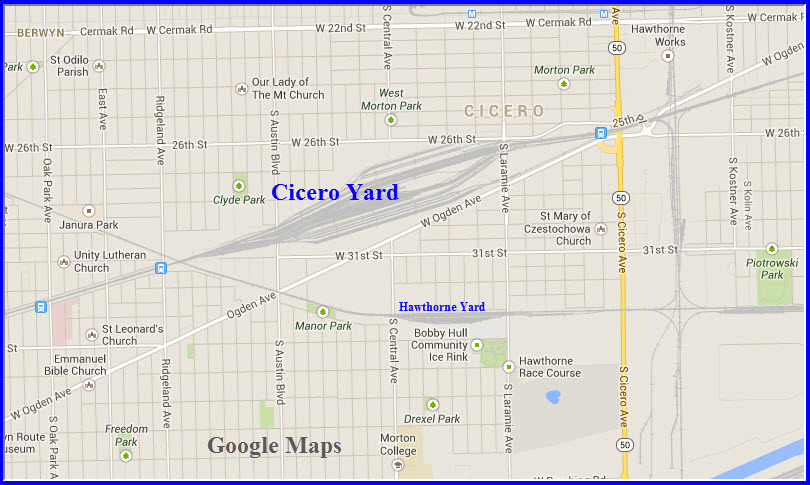
Cicero Yard
Clearing Yard
Clyde Yard
Colehour Yard
Corwith Yard
Crawford Yard (gone)
CRL TOFC Yard
Damen Ave Yard (gone)
Deering Yard (gone)
East Chicago Yard
Elsdon Yard
Englewood Yard
Eola Yard
Fordham Yard
Forest Hill Yard
Galewood Yard
Gibson Yard
Glenn Yard
Global 1 Yard East
Global 1 Yard West
Global 2 Yard
Goose Island Yard
Gresham Yard
Hammond Yard
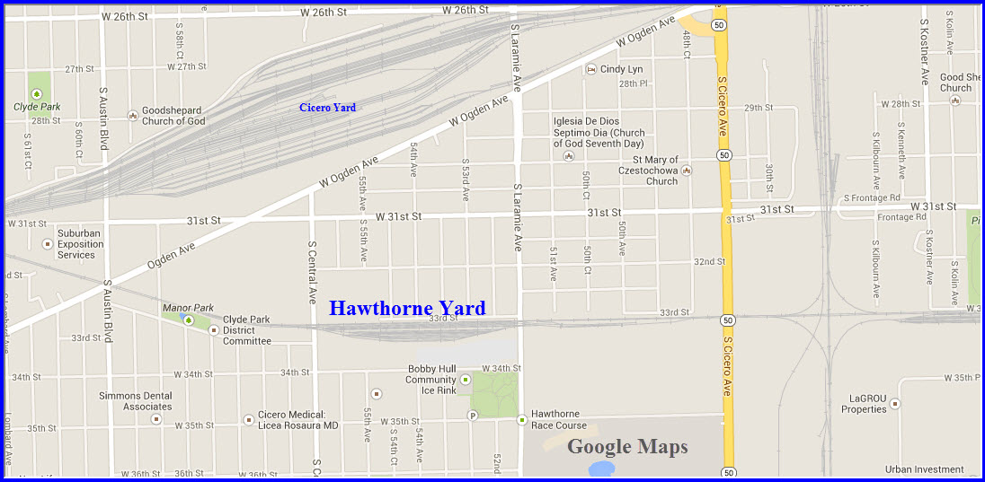
Hawthorne Yard
Holman St Yard
IMX Yard
Interchange Yard
Joliet Yard
Junction Yard
Lake Front Yard
Landers Yard
Lincoln St Coach Yard
Markham Yard
McCook Yard
Norpaul Yard
North Ave Yard
Park Manor Yard
Proviso Yard
Railport Yard
Robey St Yard - see Global 1 Yard East
Rockwell St Yard
Root St Yard
Schiller Park Yard
SOO Team Track (gone)
South Chicago Yard
South Chicago Yard - CSL
South Chicago Yard - EJE
State St Yard
West Chicago Yard (gone)
Western Ave Yard
Willow SpringsYard
Wood St Yard - see Global 1 West Yard
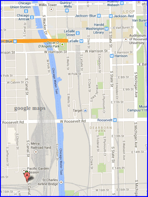
14th St Yard
GPS Coordinates: 41.866148, -87.635879
Location: Just south of Union Station
Status: Active
Current Owner/Operator: Amtrak
History: Pre Amtrak Passenger Railroads serving Union Station
Purpose: Coach Yard
Hump: no
Activity: Daily sorting and maintenance of Amtrak’s passenger cars
Tracks/Details: 2 yards in one, ~19 tracks on the north side, ~16 on the south end, tracks run north/south.
Railfan Access: South Lumber St runs along the eastern edge of the yard allowing you to get up close and personal.
Pictures can also be taken from the W Roosevelt Rd overpass, which splits the yard approximately in half.
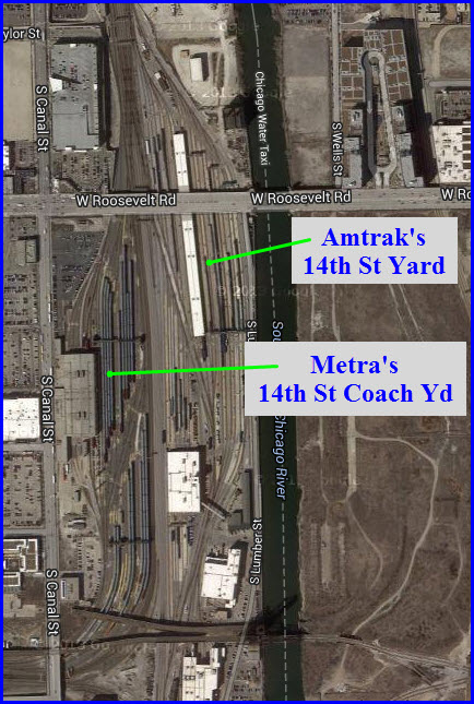
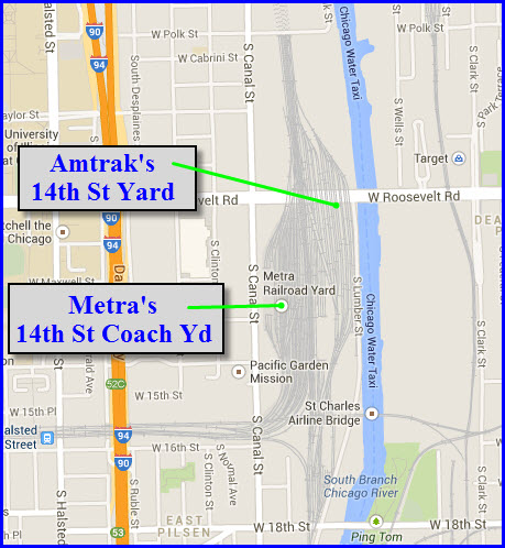
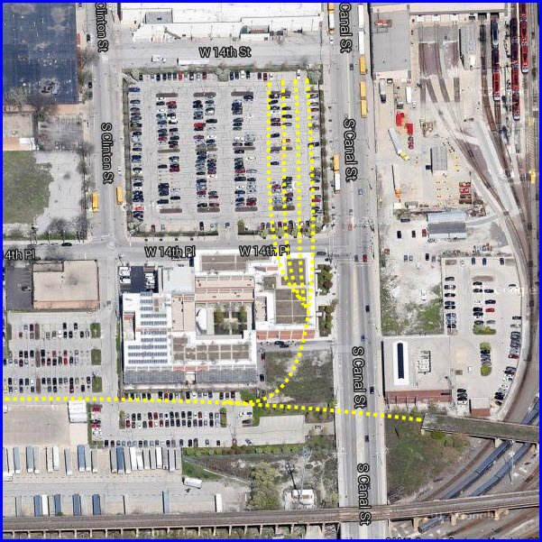
14th St Coach Yard
GPS Coordinates: 41.86424, -87.6378 (middle of the yard)
Location: ~ 1-1/2 miles from downtown, south of Chicago Union Station, west of Amtrak’s 14th St yard
Status: Active
Current Owner/Operator: Metra
History: Former CB&Q - Chicago, Burlington & Quincy yard, and all pre Metra Commuter Railroads serving Union Station
Purpose: Coach storage and maintenance
Hump: no
Activity: Daily sorting and maintenance of Metra’s passenger cars
Tracks/Details: 2 yards in one, ~23 tracks on the north end and roughly 20 tracks on the south.
Railfan Access: None, but pictures can be had from the W Roosevelt Rd overpass to the north end of the yard.
Map: see above
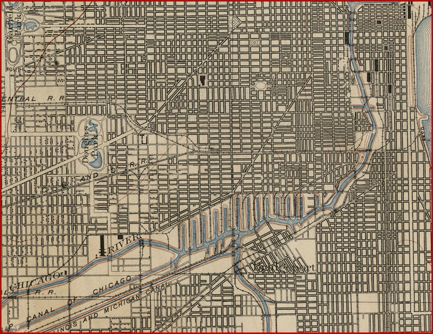
Here is the area in 1899, from the University of Texas Library:
18th St Yard
GPS Coordinates: 41.859292, -87.618477
Location: South Chicago, about 1-1/2 mile from downtown, east of 14th Street yards paralleling S. Lake Shore Dr, just west of Soldier Field.
Status: Active
Current Owner/Operator: Metra
History: IC
Purpose: Coach Yard, sorting and maintenance for Electric District
Hump: no
Activity: Pretty busy
Tracks/Details: 15, 4 of them thru tracks on the outside, 2 on each side
Railfan Access: None McCormick Place Busway parallels the yard, but you don't have access, If you can find a place to park for
the Mark Twain Park, and walk, you might have a chance, and you can't stop on the S Lake Shore Drive, besides, there is a wall between you and the trains....
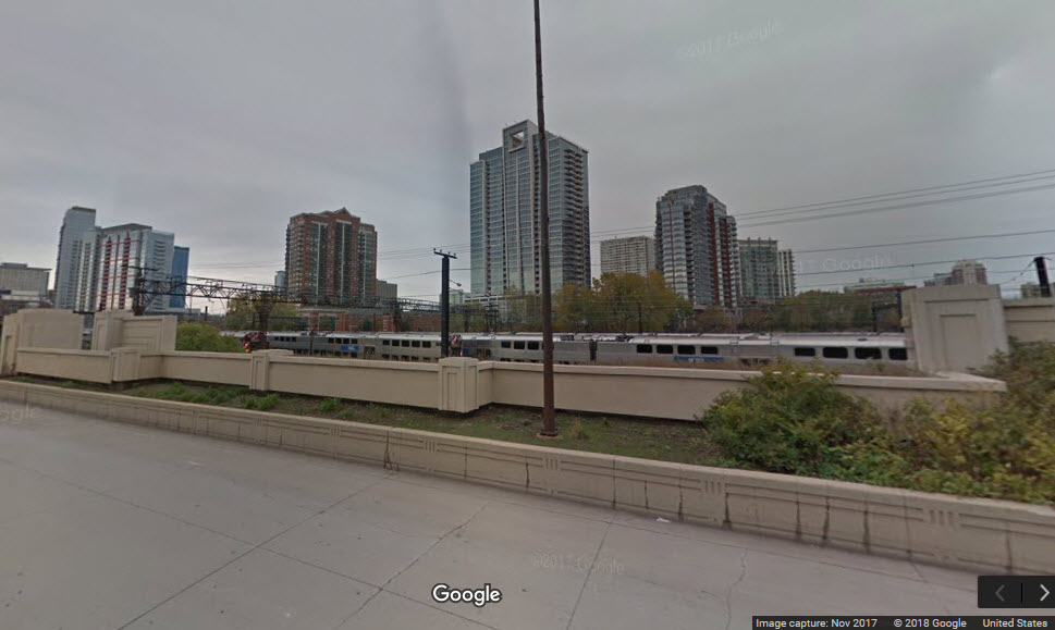 from S Lake Shore Drive
 from S Lake Shore Drive
21st St Yard
GPS Coordinates: x
Location: N
Status: Active
Current Owner/Operator: Amtrak
History: ATSF
Purpose: ?
Hump: no
Activity: ?
Tracks/Details: ?
Railfan Access: ?
22nd St Yard
Location:
Status: Active
Current Owner/Operator: b
History: c
Purpose: d
Hump: yes/no
Activity: e
Tracks/Details: ?
Railfan Access: ?
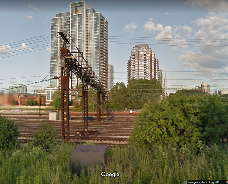
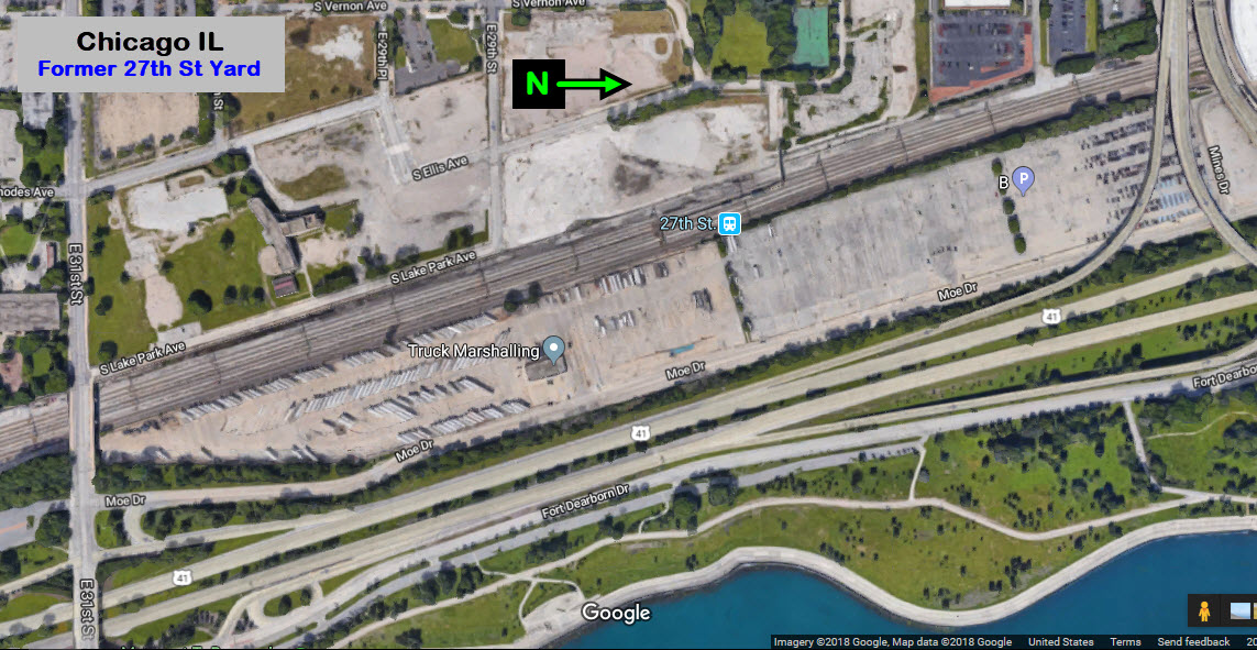
27th St Yard (gone)
GPS Coordinates: 41.843709, -87.612134
Location: 2.8 miles SSE (5:00) of downtown
Status: Torn up
Current Owner/Operator: n/a
History: ?
Purpose: ?
Hump: no
Activity: none
Tracks/Details: It is now a Marshalling Yard for 18-Wheeler Trucks
Railfan Access: n/a
33rd St Yard
GPS Coordinates: x
Location: N
Status: Active
Current Owner/Operator: U
History: ?
Purpose: ?
Hump: yes/no
Activity: ?
Tracks/Details: ?
Railfan Access: ?
35th St Yard
GPS Coordinates: 41.83086,-87.636856 (middle of the yard at 35th St
Location: South Chicago IL, about 3.2 miles from downtown, 6:30
Status: Active
Current Owner/Operator: C&EI
History: ?
Purpose: ?
Hump: yes/no
Activity: ?
Tracks/Details: 17 tracks, used to have more, maybe another 5 or 6
Railfan Access: None, all of the yard is above street level, as there are 3 underpasses for the streets
40th St Yard
GPS Coordinates: -
Location: -
Status: Active
Current Owner/Operator: -
History: CNW
Purpose: ?
Hump: yes/no
Activity: ?
Tracks/Details: ?
Railfan Access: ?
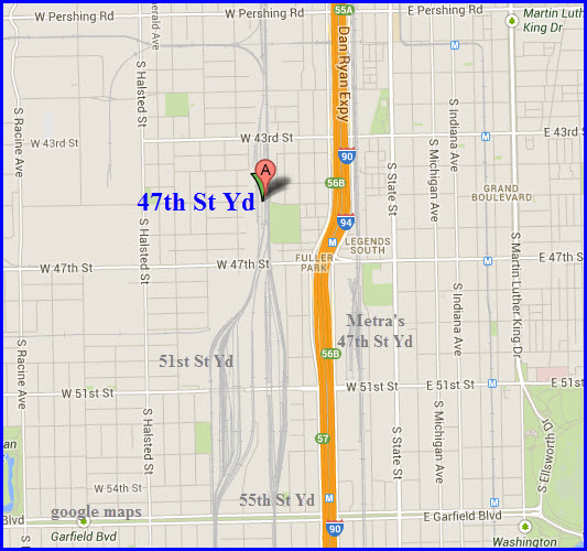
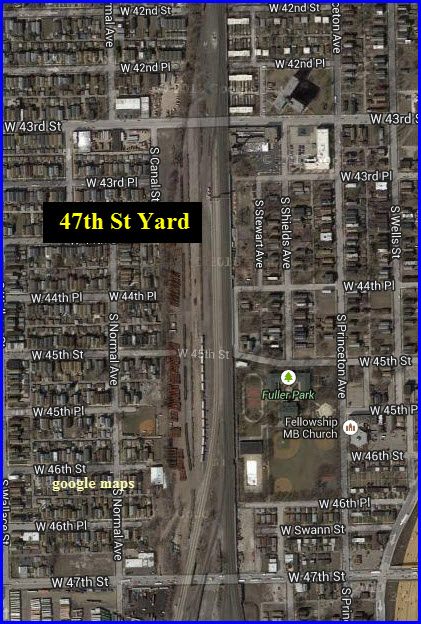
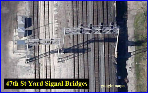
47th St Yard
GPS Coordinates: 41.812651,-87.636395
Location: South Chicago IL, Fuller Park, about 4.2 miles from downtown, 6:31
Status: Active
Current Owner/Operator: Norfolk Southern
History: Wabash, N&W
Purpose: Empty TOFC storage?
Hump: no
Activity: ?
Tracks/Details: 3 tracks, may have had an additional 9 or 10 tracks
2 signal bridges on adjacent mainlines south of 43rd St, one 2 track, and one 4 track
Railfan Access: None: Root St, 43rd St, 45th St, and 47th St all go under the yard
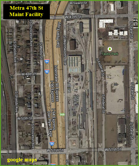
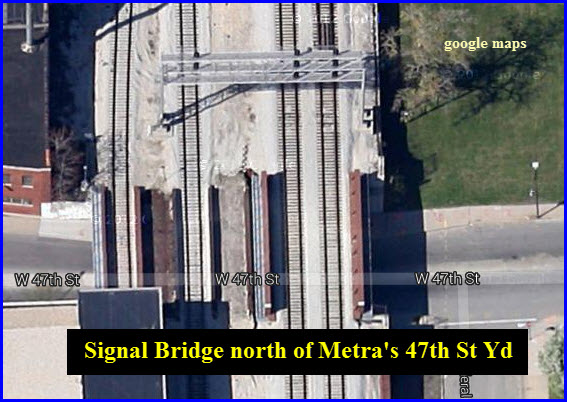
47th St Yard - Metra
GPS Coordinates: 41.805358,-87.630000
Location: South Chicago IL, Fuller Park, about 5.1m miles south of downtown, 6:00
Status: Active
Current Owner/Operator: Metra
History: C&WI, EL
Purpose: Car and engine maintenance
Hump: no
Activity: ?
Tracks/Details: ?
Railfan Access: None: 47th St and 51st St both go under the yard
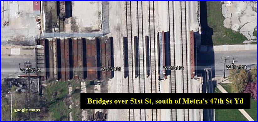
Special features/notes: Signal bridge on the north side of 47th St, there were 2 other tracks here at one time
6 unused bridges on the south side of the yard over West 51st St.
51st St Yard
GPS Coordinates: 41.801743,-87.638991 (center of the yard at 51st St)
Location:
Status: Active
Current Owner/Operator: Norfolk Southern
History: Erie, PC, CR, NS
Purpose: ?
Hump: no
Activity: ?
Tracks/Details: ?
Railfan Access: None, all streets go under the yards here.
55th St Yard
GPS Coordinates: 41.801807,-87.635407
Location:
Status: Active
Current Owner/Operator: Norfolk Southern
History: PRR, PC, CR, NS
Purpose: ?
Hump: no
Activity: ?
Tracks/Details: ?
Railfan Access: None, all streets go under the yards here.
59th St Yard - (gone)
GPS Coordinates: x
Location:
Status: Torn up
Current Owner/Operator: n/a
History: PRR
Purpose: ?
Hump: yes/no
Activity: n/a
Tracks/Details: ?
Railfan Access: n/a
83rd St Yard - (gone)
GPS Coordinates: x
Location:
Status: Torn up
Current Owner/Operator: n/a
History: CWI
Purpose: ?
Hump: yes/no
Activity: n/a
Tracks/Details: ?
Railfan Access: n/a
87th St Yard - (gone)
GPS Coordinates: x
Location:
Status: Torn up
Current Owner/Operator: n/a
History: BRC
Purpose: ?
Hump: yes/no
Activity: n/a
Tracks/Details: ?
Railfan Access: n/a
97th St Yard
GPS Coordinates: x
Location: N
Status: Active
Current Owner/Operator: NS
History: Rock Island, CRL
Purpose: ?
Hump: yes/no
Activity: ?
Tracks/Details: ?
Railfan Access: ?
Argo Yard
GPS Coordinates: x
Location:
Status: Active
Current Owner/Operator: ?
History: ?
Purpose: ?
Hump: yes/no
Activity: ?
Tracks/Details: just south of Argo crossing
Railfan Access: ?
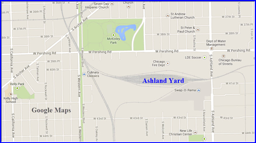
Ashland Ave Yard
GPS Coordinates: x
Location:
Status: Active
Current Owner/Operator: Norfolk Southern
History: CRIP?
Purpose: ?
Hump: yes/no
Activity: ?
Tracks/Details: ?
Railfan Access: ?
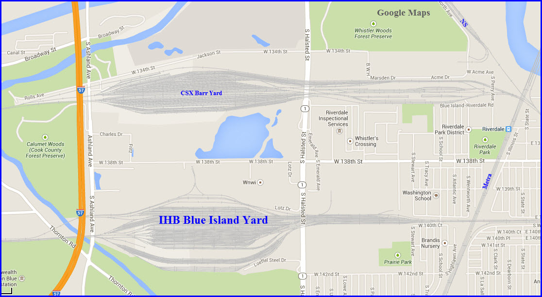
Barr Yard
The northern of the two yards in Riverdale.
GPS Coordinates: x
Location:
Status: Active
Current Owner/Operator: CSX
History: Today’s Barr Yard complex is the result of the consolidation of three smaller separate yards in 1947.
Purpose: Car classification, train building and receiving. Car repair, engine terminal, track scale.
Hump: No, it has always been flat switched.
Activity: Terminus of over the road (balanced tonnage) trains on B&O RR, Chessie System, CSX;
Terminus of unbalanced trains of the B&OCT. Handles interchange traffic.
Tracks/Details:
Eastbound Yard – 15 classification tracks (capacity 1146 cars) and 5 receiving tracks (345 cars).
Westbound Yard – 26 classification tracks (1208 cars capacity) 6 receiving tracks (capacity 500 cars). Six reconditioning tracks for car cleaning and stock car bedding.
Car repair tracks – 2 eastbound tracks (capacity 64 cars) 2 westbound tracks (capacity 54 cars).
Engine facility at the east end of Barr – had 115 ft 3-point suspension turntable, 200-ton Ogle coaling station with 28-ton dry sand section.
3—track Ogle all-electric ash handling facility. Engine House with three tracks.
Railfan Access: Limited – Halsted Street overpass gives a look at the east end of the main yard.
Thanks to Clifton L and a 1950 pamphlet from the B&OCT.
Bedford Park Yard
GPS Coordinates: 41.76587,-87.783079
Location:
Status: Active
Current Owner/Operator: CSX
History: ?
Purpose: ?
Hump: yes/no
Activity: ?
Tracks/Details: ?
Railfan Access: ?
Bensenville Yard
GPS Coordinates: 41.950714,-87.915237
Location:
Status: Active
Current Owner/Operator: Canadian Pacific
History: ?
Purpose: ?
Hump: yes/no
Activity: ?
Tracks/Details: ?
Railfan Access: ?
Blue Island Yard
The southern of the two yards in Riverdale.
GPS Coordinates: x
Location:
Status: Active
Current Owner/Operator: Indiana Harbor Belt
History: ?
Purpose: ?
Hump: yes/no
Activity: ?
Tracks/Details: ?
Railfan Access: ?
Brighton Park
GPS Coordinates: x
Location:
Status: Active
Current Owner/Operator: C
History: ?
Purpose: ?
Hump: yes/no
Activity: ?
Tracks/Details: ?
Railfan Access: ?
Burnham Yard (just north of State Line Crossing)
GPS Coordinates: x
Location:
Status: Active
Current Owner/Operator: C
History: ?
Purpose: ?
Hump: yes/no
Activity: ?
Tracks/Details: ?
Railfan Access: ?
Burr Oak Yard
GPS Coordinates: x
Location:
Status: Active
Current Owner/Operator: x
History: ?
Purpose: ?
Hump: yes/no
Activity: ?
Tracks/Details: ?
Railfan Access: ?
California Ave Yard
GPS Coordinates: x
Location:
Status: Active
Current Owner/Operator: x
History: CNW
History: ?
Purpose: ?
Hump: yes/no
Activity: ?
Tracks/Details: ?
Railfan Access: ?
Calumet Yard
GPS Coordinates: x
Location:
Status: Active
Current Owner/Operator: Norfolk Southern
History: NKP
Purpose: ?
Hump: yes/no
Activity: ?
Tracks/Details: ?
Railfan Access: ?
Canal St Yard
GPS Coordinates: x
Location:
Status: Active
Current Owner/Operator: UP
History: ?
Purpose: ?
Hump: yes/no
Activity: ?
Tracks/Details: ?
Railfan Access: ?
Canal St Yard
GPS Coordinates: x
Location:
Status: Active
Current Owner/Operator: CWI
History: ?
Purpose: ?
Hump: yes/no
Activity: ?
Tracks/Details: ?
Railfan Access: ?
Chicago Ave Yard
GPS Coordinates: x
Location:
Status: Active
Current Owner/Operator: UP
History: CNW
Purpose: ?
Hump: yes/no
Activity: ?
Tracks/Details: ?
Railfan Access: ?
Chicago Transfer Yard
GPS Coordinates: x
Location:
Status: Active
Current Owner/Operator: x
History: ?
Purpose: ?
Hump: yes/no
Activity: ?
Tracks/Details: ?
Railfan Access: ?
Cicero Yard
GPS Coordinates: 41.842679,-87.753854, from the Laramie Ave overpass
Location: Cicero IL
Status: Active
Current Owner/Operator: BNSF
History: ?
Purpose: ?
Hump: yes/no
Activity: ?
Tracks/Details: ?
Railfan Access: ?
Cico Yard
GPS Coordinates: x
Location: Cicero IL
Status: Active
Current Owner/Operator: -
History: ?
Purpose: ?
Hump: yes/no
Activity: ?
Tracks/Details: ?
Railfan Access: ?
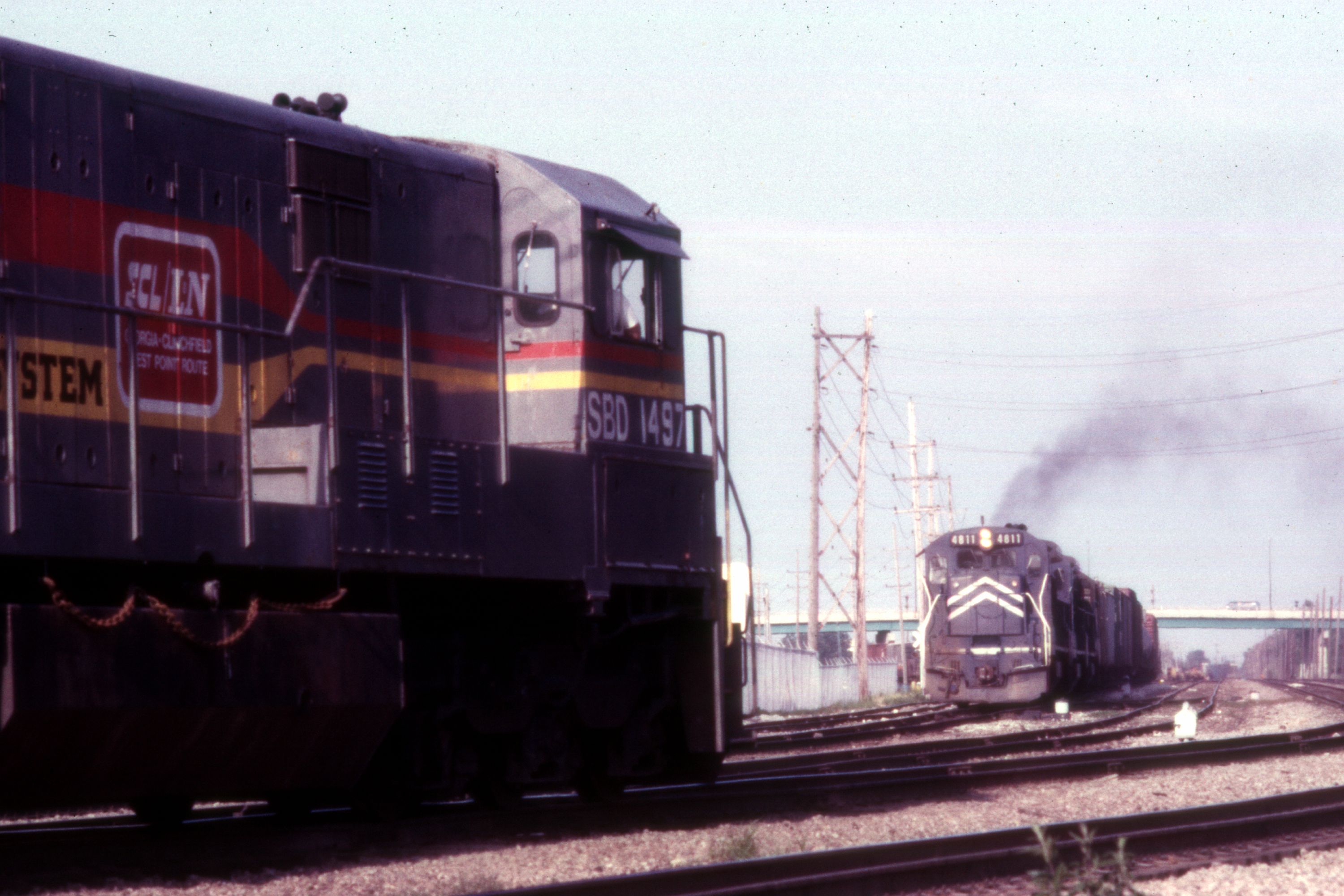
Clearing Yard
GPS Coordinates: 41.767887,-87.761321
Location:
Status: Active
Current Owner/Operator: BRC - Belt Railway of Chicago
History: ?
Purpose: ?
Hump: yes, 2
Activity: ?
Tracks/Details: ?
Railfan Access: ?
Below, a Missouri Pacific freight with #4811 in the lead, on the east side of Clearing Yard at the GTW crossing.... July 1984.
Thanks to Tim Vermande for the picture!
Clyde Yard
GPS Coordinates: x
Location: Cicero
Status: Active
Current Owner/Operator: BNSF
History: ?, BN
Purpose: ?
Hump: yes/no
Activity: ?
Tracks/Details: ?
Railfan Access: ?
Colehour Yard
GPS Coordinates: x
Location:
Status: Active
Current Owner/Operator: -
History: ?
Purpose: ?
Hump: yes/no
Activity: ?
Tracks/Details: ?
Railfan Access: ?
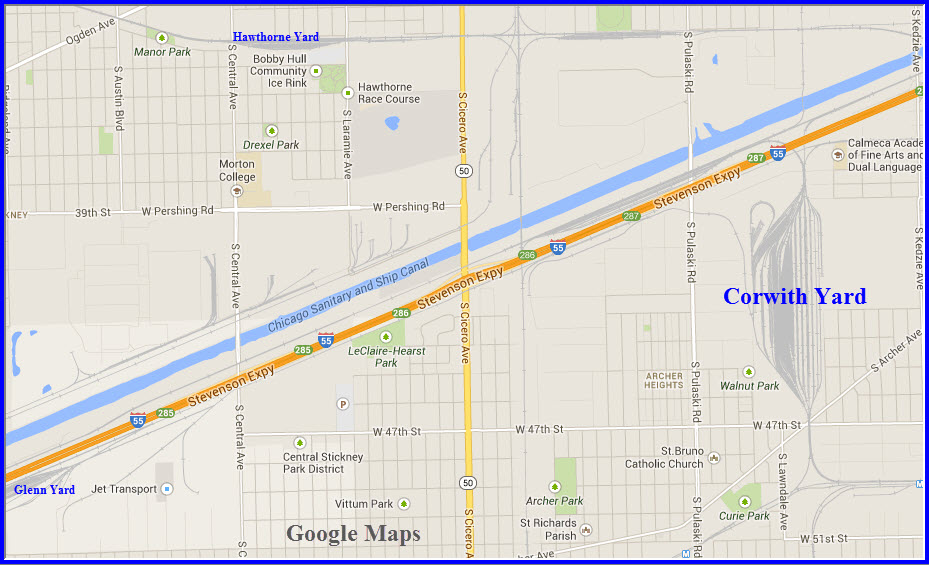
Corwith Yard
GPS Coordinates: x
Location: about 6 miles southwest of downtown Chicago.
Status: Active
Current Owner/Operator: BNSF
History: ATSF
Purpose: ?
Hump: yes/no
Activity: ?
Tracks/Details: ?
Railfan Access: ?
Crawford Yard (gone)
GPS Coordinates: x
Location:
Status: Torn up
Current Owner/Operator:n/a
History: ?
Purpose: ?
Hump: yes/no
Activity: n/a
Tracks/Details: ?
Railfan Access: n/a
CRL TOFC Yard
GPS Coordinates: x
Location: N
Status: Active
Current Owner/Operator: U
History: ?
Purpose: ?
Hump: no
Activity: ?
Tracks/Details: ?
Railfan Access: ?
Damen Ave Yard (gone)
GPS Coordinates: x
Location: N
Status: Torn up
Current Owner/Operator: n/a
History: ?
Purpose: ?
Hump: yes/no
Activity: n/a
Tracks/Details: ?
Railfan Access: n/a
Dearing Yard
GPS Coordinates: -
Location: -
Status: Active
Current Owner/Operator: -
History: ?
Purpose: ?
Hump: yes/no
Activity: ?
Tracks/Details: ?
Railfan Access: ?
East Chicago Yard
GPS Coordinates: x
Location: -
Status: Active
Current Owner/Operator: -
History: ?
Purpose: ?
Hump: yes/no
Activity: ?
Tracks/Details: ?
Railfan Access: ?
Elsdon Yard
GPS Coordinates: x
Location: -
Status: Active
Current Owner/Operator: -
History: ?
Purpose: ?
Hump: yes/no
Activity: ?
Tracks/Details: ?
Railfan Access: ?
Englewood Yard
GPS Coordinates: x
Location: -
Status: Active
Current Owner/Operator: -
History: ?
Purpose: ?
Hump: yes/no
Activity: ?
Tracks/Details: ?
Railfan Access: ?
Eola Yard
GPS Coordinates: x
Location: Just east of Aurora
Status: Active
Current Owner/Operator: BNSF
History: ?, BN
Purpose: ?
Hump: yes/no
Activity: ?
Tracks/Details: ?
Railfan Access: ?
Fordham Yard
GPS Coordinates: x
Location: -
Status: Active
Current Owner/Operator: -
History: ?
Purpose: ?
Hump: yes/no
Activity: ?
Tracks/Details: ?
Railfan Access: ?
Forest Hill Yard
GPS Coordinates: x
Location: -
Status: Active
Current Owner/Operator: -
History: ?
Purpose: ?
Hump: yes/no
Activity: ?
Tracks/Details: ?
Railfan Access: ?
Galewood Yard
GPS Coordinates: x
Location: -
Status: Active
Current Owner/Operator: -
History: ?
Purpose: ?
Hump: yes/no
Activity: ?
Tracks/Details: ?
Railfan Access: ?
Gibson Yard
GPS Coordinates: x
Location: -
Status: Active
Current Owner/Operator: -
History: ?
Purpose: ?
Hump: yes/no
Activity: ?
Tracks/Details: ?
Railfan Access: ?
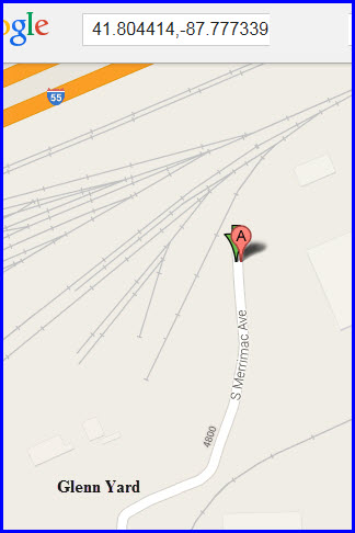
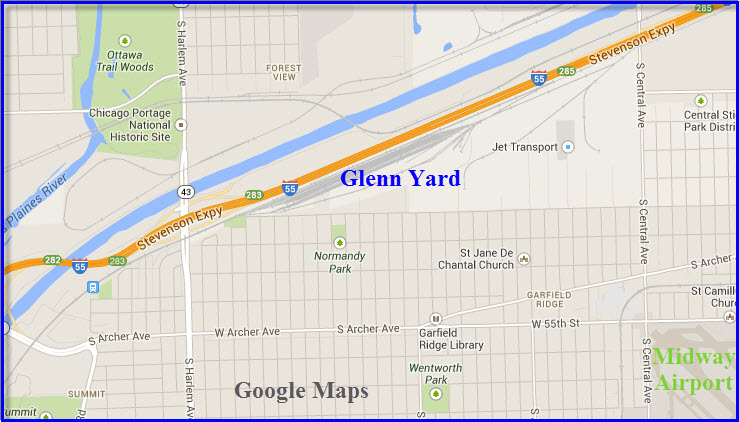
Glenn Yard
GPS Coordinates: 41.804414,-87.777339
Location: -
Status: Active
History: ?
Purpose: ?
Hump: yes/no
Activity: ?
Tracks/Details: ?
Railfan Access: ?
Global 1 Yard East
GPS Coordinates: x
Location: Chicago IL
Status: Active
Current Owner/Operator: UP
History: former B&OCT Robey St Yard, then CNW
Purpose: ?
Hump: yes/no
Activity: ?
Tracks/Details: ?
Railfan Access: ?
Global 1 Yard West
GPS Coordinates: x
Location: Chicago IL
Status: Active
Current Owner/Operator: UP
History: former CNW Wood St Yard
Purpose: ?
Hump: yes/no
Activity: ?
Tracks/Details: ?
Railfan Access: ?
Global 2 Yard
GPS Coordinates: x
Location: Northlake IL
Status: Active
Current Owner/Operator: UP
History: ?
Purpose: ?
Hump: yes/no
Activity: ?
Tracks/Details: ?
Railfan Access: ?
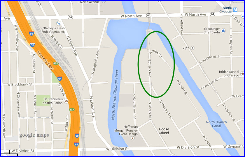
Goose Island Yard
GPS Coordinates: 41.908881,-87.655492
Location: NW Chicago IL, about 2 1/2 miles from downtown
Status: Torn up
Current Owner/Operator: n/a
History: ?
Purpose: switching for local customers
Hump: no
Activity: n/a
Tracks/Details: ?
Railfan Access: ?
Gresham Yard
GPS Coordinates: x
Location: -
Status: Active
Current Owner/Operator: -
History: ?
Purpose: ?
Hump: yes/no
Activity: ?
Tracks/Details: ?
Railfan Access: ?
Hammond Yard
GPS Coordinates: x
Location: -
Status: Active
Current Owner/Operator: CSX?
History: Monon
Purpose: ?
Hump: yes/no
Activity: ?
Tracks/Details: ?
Railfan Access: ?
Hawthorne Yard
GPS Coordinates: 41.832607,-87.758639, 33rd St at S. 54th Ave
Location: -
Status: Active
Current Owner/Operator: Canadian National
History: ?
Purpose: ?
Hump: yes/no
Activity: ?
Tracks/Details: ?
Railfan Access: ?
Holman St Yard
GPS Coordinates: x
Location: -
Status: Active
Current Owner/Operator: -
History: ?
Purpose: ?
Hump: yes/no
Activity: ?
Tracks/Details: ?
Railfan Access: ?
IMX Yard
GPS Coordinates: x
Location: -
Status: Active
Current Owner/Operator: -
History: ?
Purpose: ?
Hump: yes/no
Activity: ?
Tracks/Details: ?
Railfan Access: ?
Interchange Yard
GPS Coordinates: x
Location: -
Status: Active
Current Owner/Operator: -
History: ?
Purpose: ?
Hump: yes/no
Activity: ?
Tracks/Details: ?
Railfan Access: ?
Joliet Yard
GPS Coordinates: x
Location: Joliet IL
Status: Active
Current Owner/Operator: -
History: ?
Purpose: ?
Hump: yes/no
Activity: ?
Tracks/Details: ?
Railfan Access: ?
Junction Yard
GPS Coordinates: x
Location: -
Status: Active
Current Owner/Operator: -
History: ?
Purpose: ?
Hump: yes/no
Activity: ?
Tracks/Details: ?
Railfan Access: ?
Lake Front Yard
GPS Coordinates: x
Location: North side, east Chicago IL
Status: Active
Current Owner/Operator: -
History: ?
Purpose: ?
Hump: yes/no
Activity: ?
Tracks/Details: ?
Railfan Access>: ?
Landers Yard
GPS Coordinates: x
Location: -
Status: Active
Current Owner/Operator: -
History: ?
Purpose: ?
Hump: yes/no
Activity: ?
Tracks/Details: ?
Railfan Access: ?
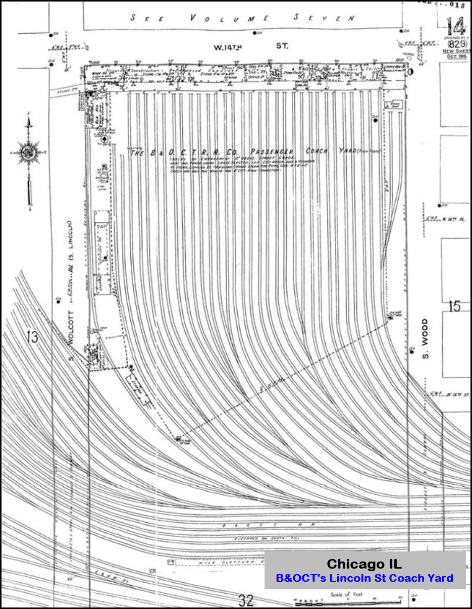
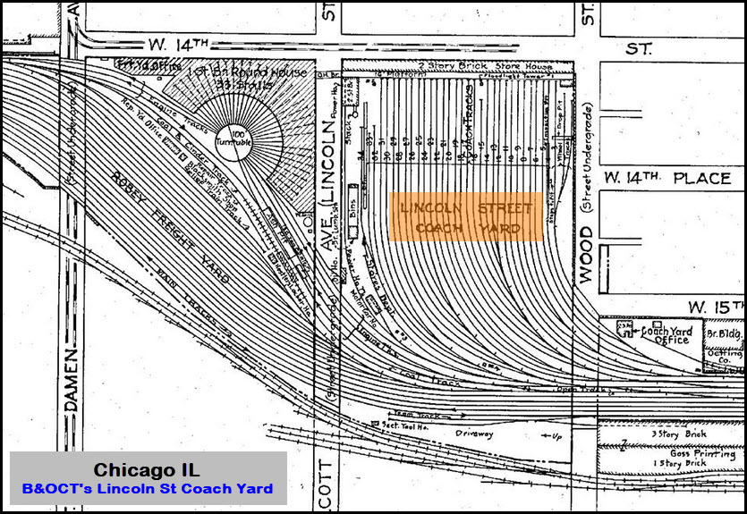
Lincoln St Coach Yard
GPS Coordinates: x
Location: -
Status: gone
Current Owner/Operator: N/A
History: Former coach yard of the B&OCT
Purpose: Passenger car storage
Hump: no
Activity: Heavy during "the day"
Tracks/Details: 34 tracks, adjoins Robey Freight Yard
Railfan Access: N/A
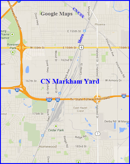
Markham Yard
GPS Coordinates: 41.568036,-87.662423, Maple Rd at the bend to Harwood Ave
Location: -
Status: Active
Current Owner/Operator: Canadian National
History: ?
Purpose: ?
Hump: yes/no
Activity: ?
Tracks/Details: ?
Railfan Access: ?
McCook Yard
GPS Coordinates: x
Location: -
Status: Active
Current Owner/Operator: -
History: ?
Purpose: ?
Hump: yes/no
Activity: ?
Tracks/Details: smaller yard, no power is kept here
Railfan Access: ?
Norpaul Yard
GPS Coordinates: x
Location: -
Status: Active
Current Owner/Operator: -
History: ?
Purpose: ?
Hump: yes/no
Activity: ?
Tracks/Details: ?
Railfan Access: ?
North Ave Yard
GPS Coordinates: 41.909032,-87.662069
Location: NW Chicago IL, about 2 1/2 miles from downtown
Status: Active
Current Owner/Operator: UP?
History: CNW?
History: ?
Purpose: ?
Hump: no
Activity: ?
Tracks/Details: ?
Railfan Access: ?
Park Manor Yard
GPS Coordinates: x
Location: -
Status: Active
Current Owner/Operator: -
History: ?
Purpose: ?
Hump: yes/no
Activity: ?
Tracks/Details: ?
Railfan Access: ?
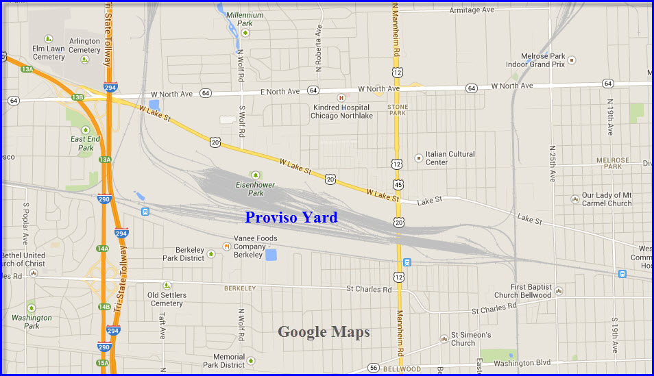
Proviso Yard
GPS Coordinates: 41.89398,-87.883555, at the middle of the Mannheim Rd overpass
Location: located in Melrose Park IL, 14 miles west of downtown Chicago.
Status: Active
Current Owner/Operator: Union Pacific
History: Former CNW Yard
Purpose: ?
Hump: yes/no
Activity: ?
Tracks/Details: ?
Railfan Access ?
Railport Yard
GPS Coordinates: x
Location: -
Status: Active
Current Owner/Operator: -
History: ?
Purpose: ?
Hump: yes/no
Activity: ?
Tracks/Details: ?
Railfan Access
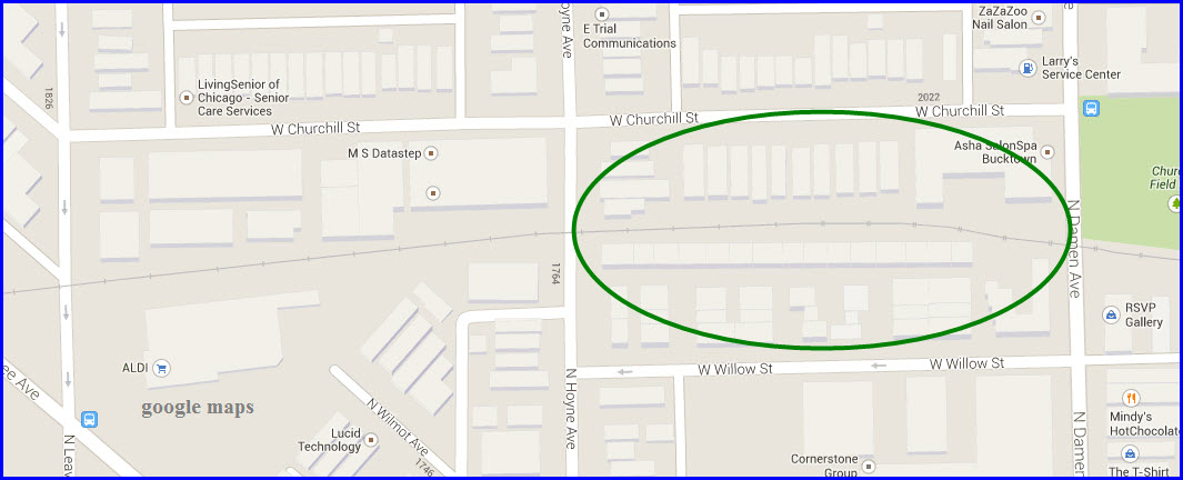
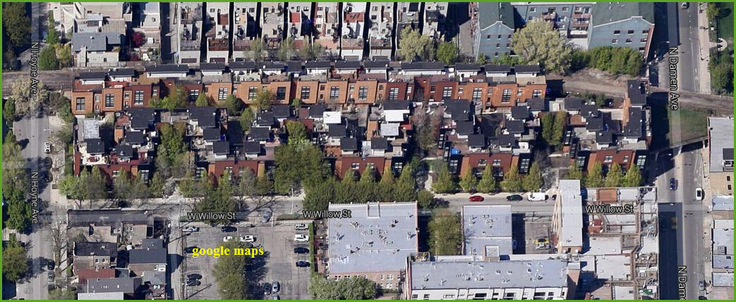
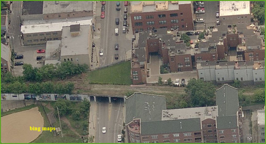
Robey St Yard (gone)
Also see Global 1 East
GPS Coordinates: 41.914294,-87.678977
Location: Clyborn IL
Status: Torn up
Current Owner/Operator: n/a
History: MILW?
Purpose: local storage yard
Hump: no
Activity: n/a
Tracks/Details: You can plainly see from the aerial shots, the new buildings, and the overpass at the throat of the yard. I wonder if the people living there get to use the now open space? The CNW purchased B&OCT land back in 1983 (12 years prior to the CNW/UPRR merger) to combine with the existing CNW Wood St Yard facility. The Global One Terminal opened in 1984.
Railfan Access: N/A
Rockwell St Yard
GPS Coordinates: 41.758474, -87.699871
Location: - Just north of Ashburn IL
Status: Active
Current Owner/Operator: - CSX
History: former C&O yard
Purpose: ?
Hump: no
Activity: Medium
Tracks/Details: 24
Railfan Access none
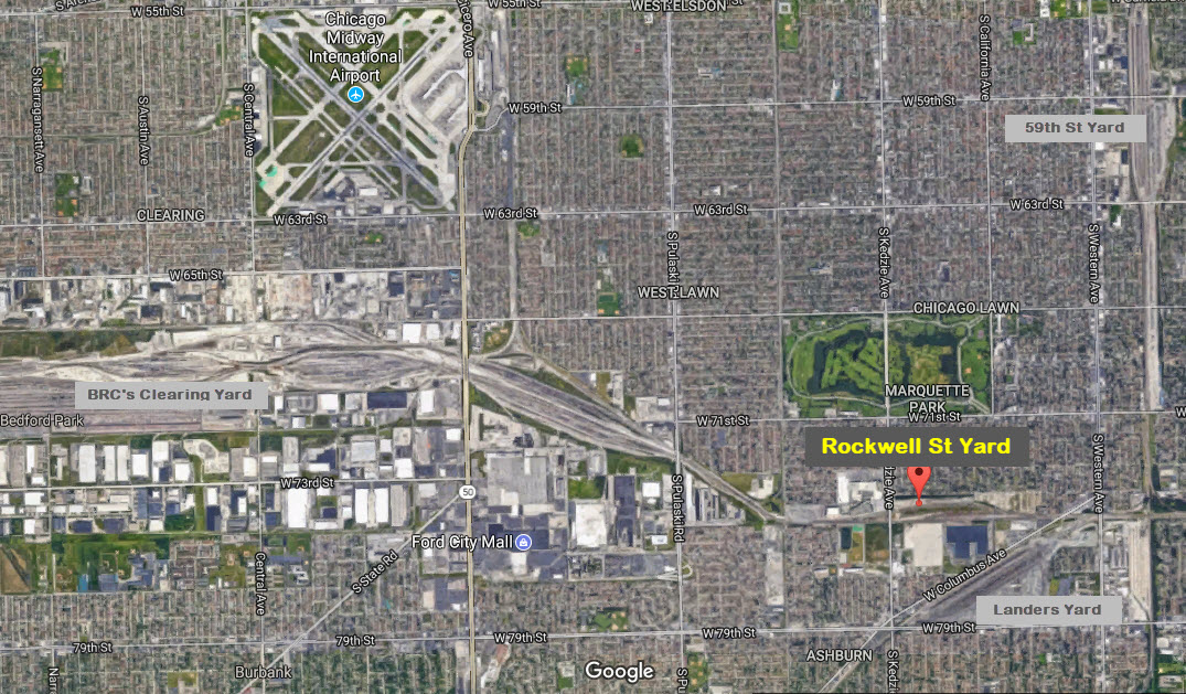
 Photo by Jim Raymond
 https://www.pinterest.com/pin/429812358161054360/
 Root St Yard - Gone
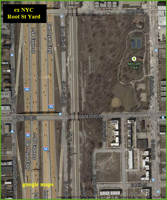
GPS Coordinates: 41.817856,-87.628369
Location: South Chicago IL, 4 miles from downtown, 6:00
Status: Torn up
Current Owner/Operator: n/a
History: ex NYC yard AND ex Rock Island yard
Purpose: ?
Hump: no
Activity: n/a
Tracks/Details: I'm kinda amazed there is still any evidence of the yard left
Railfan Access: n/a
More Info: Steam Powered Video's map book shows the east side is the abandoned NYC Root Street Yard. I presume the west side was the Rock Island Root Street Yard. The west side has been totally obliterated by the Dan Ryan Expressway. Only some of the NYC yard has been redeveloped. You can still see bridges across 43rd Street and ballast trails (from the additional source listed below).
http://industrialscenery.blogspot.com/2016/06/rock-island-and-nyc-root-street-yards.html
 1938
1938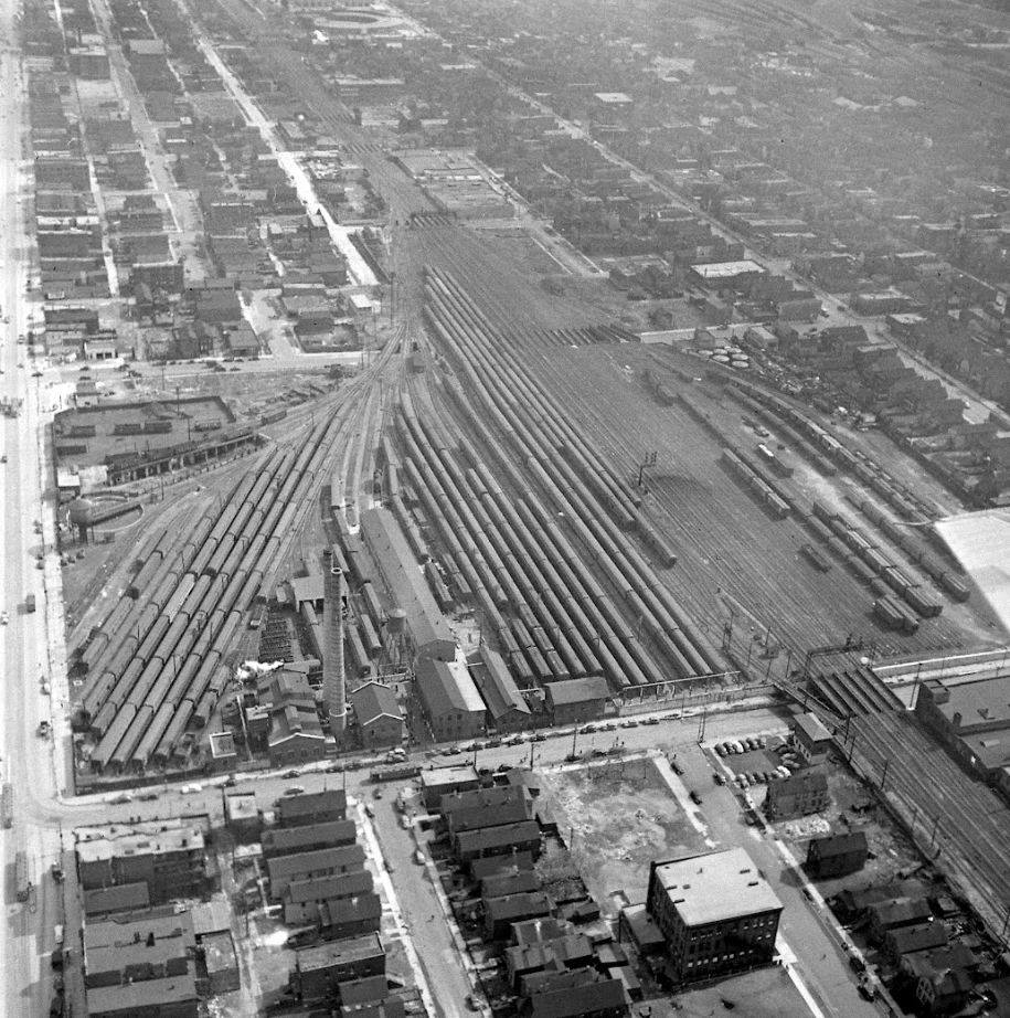
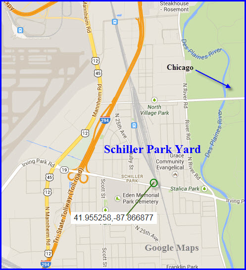
Schiller Park Yard
GPS Coordinates: 41.955258,-87.866877, from the Skate Park next to the south end of the yard, off Irving Park Rd
Location:
Status: Active
Current Owner/Operator: Canadian National
History: ?
Purpose: ?
Hump: no
Activity: ?
Tracks/Details: nice set of signals here too!
Railfan Access: ?
SOO Team Track (gone)
GPS Coordinates: 41.861068,-87.639388
Location: South Chicago IL, about a mile from downtown (~7:00), near the two 14th St yards
Status: Torn up
Current Owner/Operator: n/a
History: ?
Purpose: ?
Hump: no
Activity: n/a
Tracks/Details: ?
Railfan Access: n/a
South Chicago Yard
GPS Coordinates: x
Location: -
Status: Active
Current Owner/Operator:-
History: ?
Purpose: ?
Hump: yes/no
Activity: ?
Tracks/Details: ?
Railfan Access: ?
South Chicago Yard - CSL
GPS Coordinates: x
Location: -
Status: Active
Current Owner/Operator: -
History: ?
Purpose: ?
Hump: yes/no
Activity: ?
Tracks/Details: ?
Railfan Access: ?
South Chicago Yard
GPS Coordinates: x
Location: -
Status: Active
Current Owner/Operator: -
History: EJE
Purpose: ?
Hump: yes/no
Activity: ?
Tracks/Details: ?
Railfan Access: ?
State Yard
GPS Coordinates: x
Location: -
Status: Active
Current Owner/Operator: -
History: CNW
Purpose: ?
Hump: yes/no
Activity: ?
Tracks/Details: ?
Railfan Access: ?
West Chicago Yard (gone)
GPS Coordinates: x
Location: -
Status: Torn up
Current Owner/Operator: n/a
History: BRC - Belt Railway of Chicago
Purpose: ?
Hump: no
Activity: n/a
Tracks/Details: ?
Railfan Access: n/a
Western Ave Yard GPS Coordinates: x
Location: -
Status: Active
Current Owner/Operator: -
History: ?
Purpose: ?
Hump: yes/no
Activity: ?
Tracks/Details: ?
Railfan Access: ?
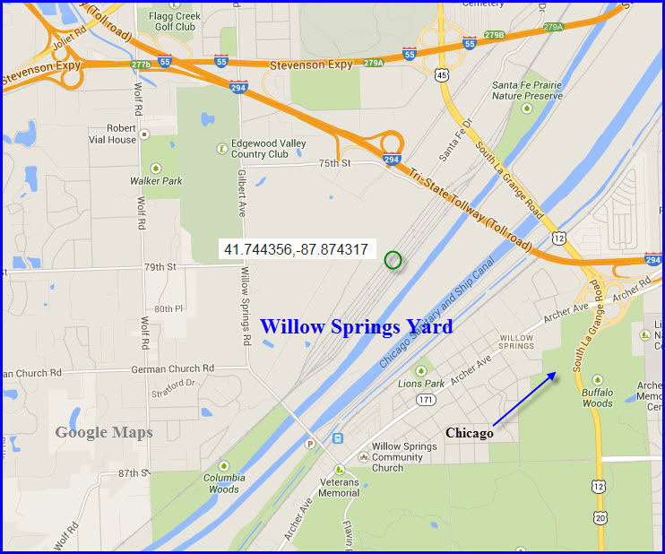
Willow Springs Yard
GPS Coordinates: 41.744356,-87.874317
Location:
Status: Active
Current Owner/Operator: BNSF
History: Former ATSF yard
Purpose: ?
Hump: no
Activity: ?
Tracks/Details: A smaller yard
Railfan Access: ?
Wood St Yard
see Global 1 West
CHICAGO RAILFAN GUIDE HOME
RAILFAN GUIDES HOME
RAILROAD SIGNALS HOME
NEW 11/5/2013
Last Modified
06-Feb-2018