RAILFAN GUIDES of the U.S.
Todd's Railfan Guide to
PARIS, FRANCE
The Trains of the SNCF
In General
Getting Here
Map
Pictures
Signals
Floobydust
RAILROAD SIGNALS HOME
Location / Name:
Paris, France
What's Here:
Trains
Trains
and more Trains
Data:
GPS Coordinates: as needed
Phone: n/a
ZIP: n/a
Access by train/transit:
All over the place! :-)
The Scoop:
This page is just an introduction to the intercity trains that serve Paris.
The SNCF is France's equivalent to Amtrak, it stands for: Société Nationale des Chemins de fer Français. Founded in 1938, it operates the country's national rail traffic along with Monaco, including the TGV, on France's high-speed rail network. Its functions include operation of railway services for passengers and freight, and maintenance and signaling of rail infrastructure. The railway network consists of about 35,000 km (22,000 mi) of route, of which 2,600 km (1,600 mi) are high-speed lines and 14,500 km (9,000 mi) electrified. About 14,000 trains are operated daily.
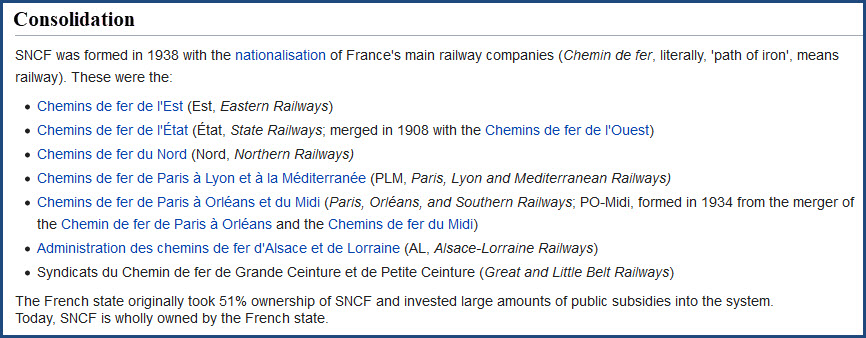
As mentioned above, the SNCF was founded in 1938 with the merger/consolidation of the following railways:
TGV High-Speed Service:
The SNCF operates a system of high speed intercity trains, called the TGV, or Train à Grande Vitesse (high-speed train). The TGV opened to the public between Paris and Lyon on 27SEP1981. The TGV was the world's third commercial standard gauge high-speed train service, after Japan's Shinkansen, which connected Tokyo and Osaka on 1OCT1964, and Britain's InterCity 125 on main lines such as the East Coast Main Line, which entered service in 1976. I have a separate page for the TGV's.
Acknowledgements:
Wikipedia
Open Railway Map
Google Maps
Websites and other additional information sources of interest for the area:
https://www.sncf.com/fr
https://www.sncf.com/en
https://en.wikipedia.org/wiki/SNCF
https://en.wikipedia.org/wiki/TGV
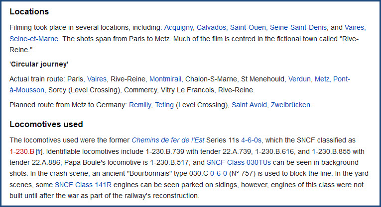
https://en.wikipedia.org/wiki/The_Train_(1964_film)
Map
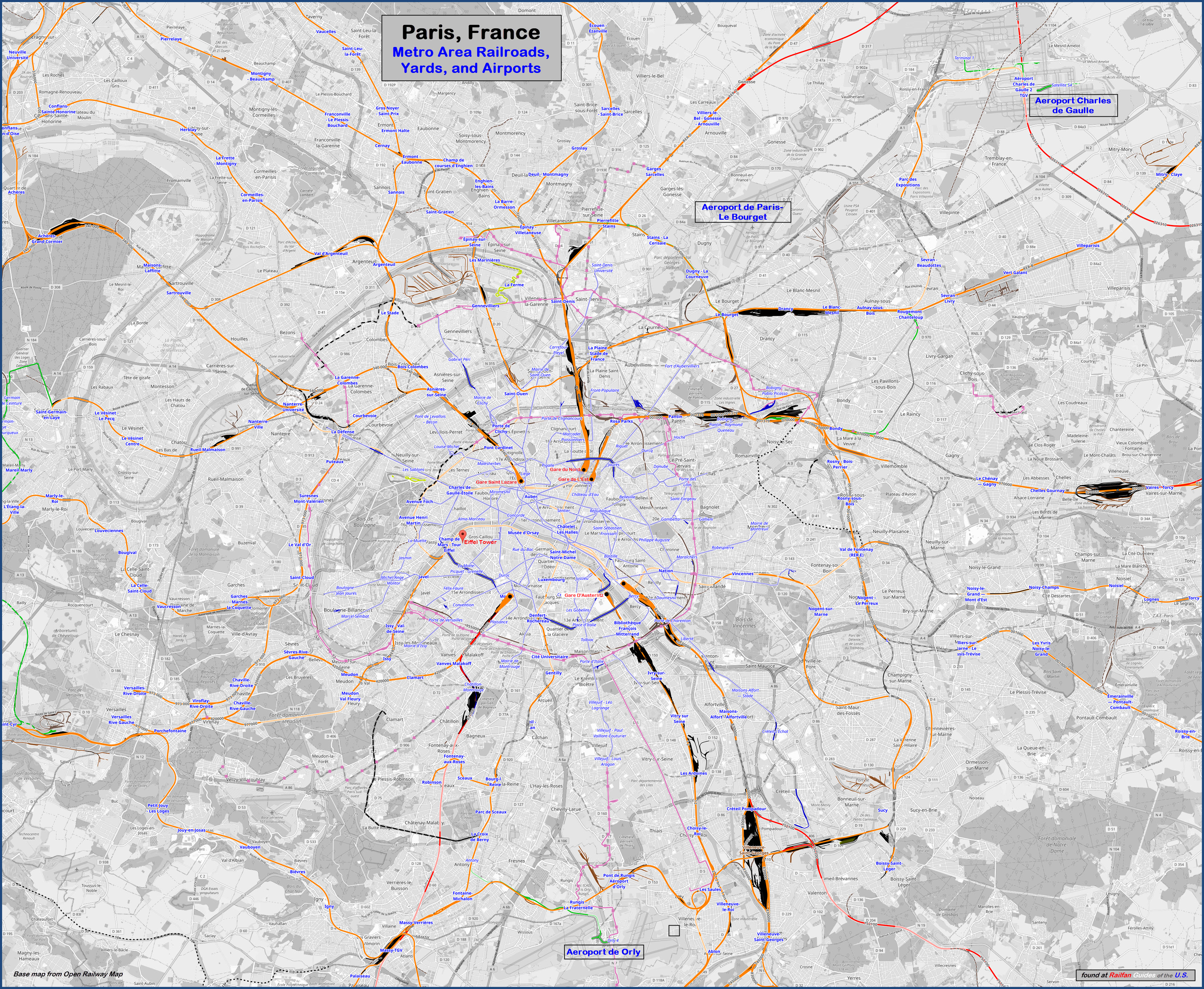
Sorry, this map is about a 4meg JPEG, and is comprised of about 40 separate
screenshots....
https://www.openrailwaymap.org/
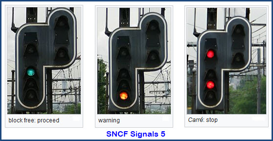
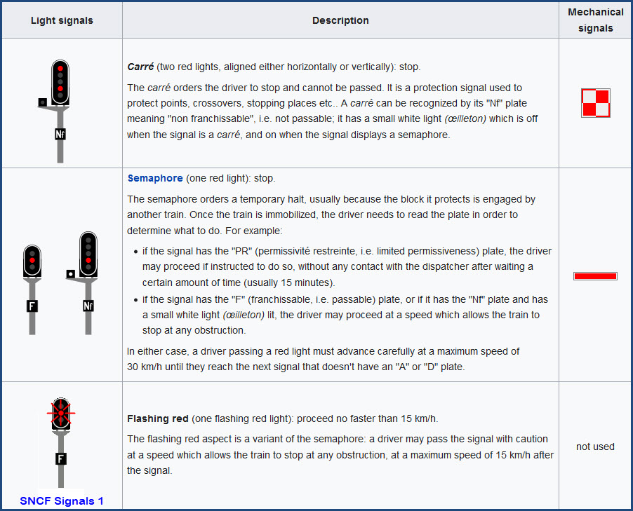
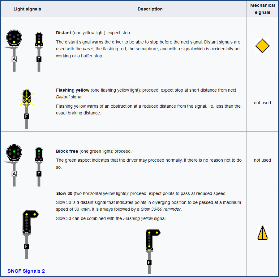
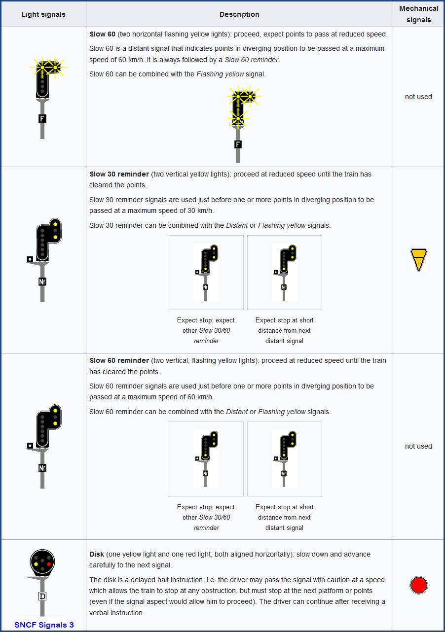
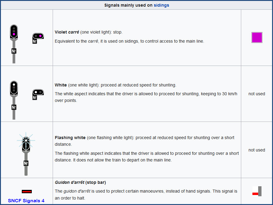
Whenever you go to a "foreign" line, you need to be able to read the signals in order to know what is going on. Although French signals loosely follow their American counterparts, there are still many differences that demand your attention. Here is a quick rundown from the Wikipedia page.
https://en.wikipedia.org/wiki/French_railway_signalling
http://www.sh1.org/sncf/index.htm
http://www.railfaneurope.net/tgv/signals.html
The SNCF in the movies....
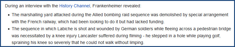
The Train:
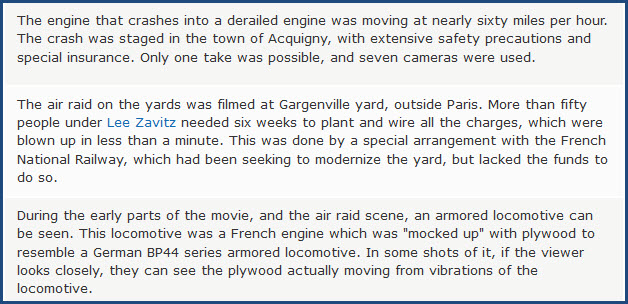
If you love trains, who has NOT seen the movie THE TRAIN? Although the movie itself itself takes place during WWII, it was filmed in 1964, after the SNCF was formed. SNCF feeling a financial crunch at the time, saw an opportunity when they wanted to "remove" the Gargenville rail yard, and let the movie producers blow up the rail yard during the filming - something that worked out for both parties.

Disclaimers:
I love trains, and I love signals. I am not an expert. My webpages reflect what I find on the topic of the page. This is something I have fun with while trying to help others.
Please Note: Since the main focus of my two websites is railroad signals, the railfan guides are oriented towards the signal fan being able to locate them. For those of you into the modeling aspect of our hobby, my indexa page has a list of almost everything railroad oriented I can think of to provide you with at least a few pictures to help you detail your pike.
If this is a railfan page, every effort has been made to make sure that the information contained on this map and in this railfan guide is correct. Once in a while, an error may creep in :-)
My philosophy: Pictures and maps are worth a thousand words, especially for railfanning. Text descriptions only get you so far, especially if you get lost or disoriented. Take along good maps.... a GPS is OK to get somewhere, but maps are still better if you get lost! I belong to AAA, which allows you to get local maps for free when you visit the local branches. ADC puts out a nice series of county maps for the Washington DC area, but their state maps do not have the railroads on them. If you can find em, I like the National Geographic map book of the U.S..... good, clear, and concise graphics, and they do a really good job of showing you where tourist type attractions are, although they too lack the railroads. Other notes about specific areas will show up on that page if known.
Aerial shots were taken from either Google or Bing Maps as noted. Screen captures are made with Snagit, a Techsmith product... a great tool if you have never used it!
By the way, floobydust is a term I picked up 30-40 years ago from a National Semiconductor data book, and means miscellaneous and/or other stuff.
Pictures and additional information is always needed if anyone feels inclined to take 'em, send 'em, and share 'em, or if you have something to add or correct.... credit is always given! Please be NICE!!! Contact info is here
Beware: If used as a source, ANYTHING from Wikipedia must be treated as being possibly inaccurate, wrong, or not true.
RAILFAN GUIDES HOME
RAILROAD SIGNALS HOME
NEW MAR16/2021
Last Modified 17-Mar-2021