RAILFAN GUIDES of the U.S.
Robert Mann's Railfan Guide to
JACKSONVILLE FL
the West Side
CSXT
/ FORMER ATLANTIC COAST LINE 'A' LINE SOUTH
In General
Getting Here
Map
Details - North Map
Details - South Map
Hotels
Floobydust
USGS Map
RAILROAD SIGNALS HOME
This guide deals with the west side of Jacksonville and the former ACL line.
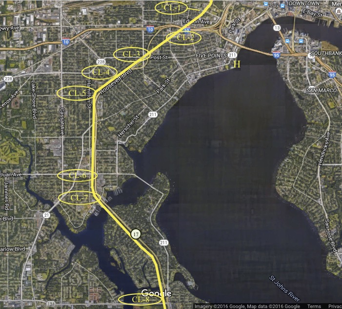
The locations below correspond with those on the map of the blue collar 'Westside' of Jacksonville, the use of the term 'CL' sets apart the areas of the city
served by the CSX on the former Atlantic Coast Line.
SAFETY
No place is perfectly safe, but my personal safety rating is based on 60+ years as a Jacksonville resident with extensive periods of time spent in such diverse
places as Medellin, Colombia; Rio De Janeiro, Brazil; Oklahoma City, Oklahoma; Portland, Oregon or Los Angeles, California, and at least an equal amount of time as a
railfan and Florida historian. While I'm certainly not claiming it's scientific or fool proof it should at the very least give you some idea of what to expect. I base it on the familiar scale of 0-10, with 0 being the
worst and 10 being the safest possible situation. I make no guarantees or promises but trust it will aid you in some way.
Acknowledgement: I would like to thank Robert Mann for taking the
time to write up this railfan guide for ya'll and sending it in to share
with everyone. I hope you especially enjoy the extra tidbits he has
thrown in so when you railfan the area, you can sound like you are from
there! It's always nice to know a little more about the area you are
in and some history about it. Especially welcome are his suggestions on where to eat and
where to stay, for most maps (including my own) only tell you where they are,
but never HOW they are!
Exit 361 from I-10 drops you off onto US 17, Roosevelt Blvd.
US 17/Roosevelt Blvd follows the right-of-way for pretty much the entire length of this guide.
Down at the south end of the guide, exit 36 from I-295 will get you off at US-17.
Details
CSXT / FORMER ATLANTIC COAST LINE 'A' LINE NORTH
 Take me to:
CL-1
CL-2
CL-3
CL-4
CL-5
CL-6
CL-7
Take me to:
CL-1
CL-2
CL-3
CL-4
CL-5
CL-6
CL-7Location CL-1
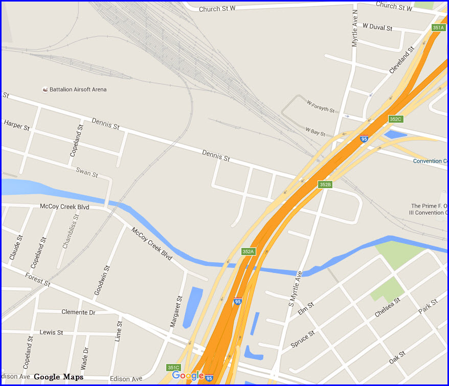
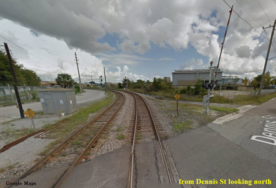
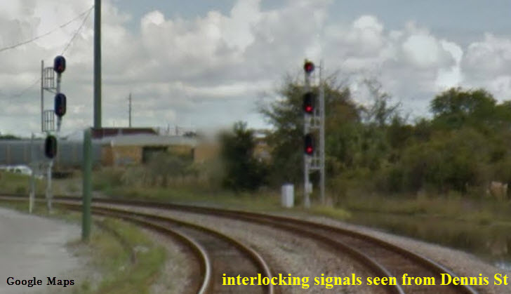
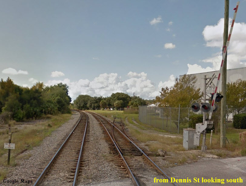
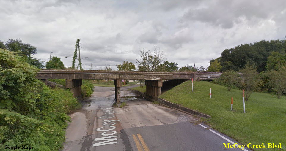
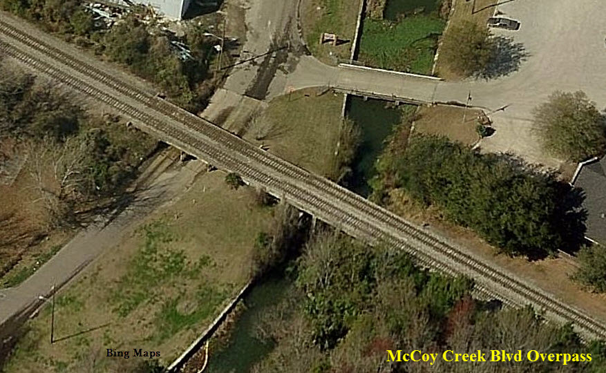
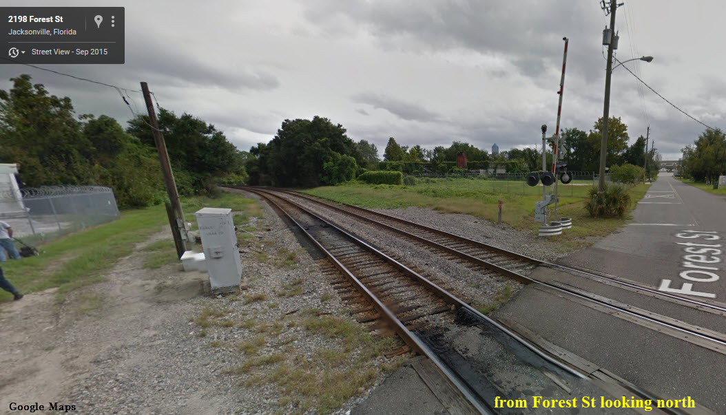
DENNIS STREET, McCOY CREEK BLVD, and FOREST STREET
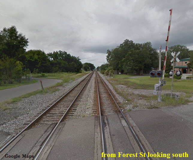
From the old Dennis Street Interlocking south three diverse locations afford photo opportunities for the careful, observant railfan group. Dennis Street itself is in the historic underbelly of Jacksonville's industrial reputation, if you're a Floridian, from the seafood on your table, to the commercial freezers it was stored in or the concrete floor you stand on, some of it likely came from within a stones throw of this district. Just to the east is the old Myrtle Avenue 'Subway', of the great Jacksonville Traction Company, it's a fun diversion but I wouldn't suggest exploring the back side of the old Terminal on foot, in short it can be deadly. At Dennis Street one can see the remaining legs of the wye into the Jacksonville Terminal, the nearby cement plant often has some unique rare power on hand and if permission is sought, they are generally friendly. At McCoy's Creek Blvd the CSX/Amtrak mainline crosses the creek on a dated and crumbling viaduct making for some fun contrast shots of old and new. By the way, you are now standing in the middle of one of Florida's little known Civil War battlefields. To the south Forest, Edison and Stockton Streets are just so-so locations probably not worth the trouble or risk. Traffic on the 'A Line,' today is rather light and long waits might be involved in catching something worth shooting, Amtrak however offers a scheduled sure shot. Lodging is no where to be seen and food is better left to a nearby historic district parking near the corner of Park and King Streets. My personal safety rating for the entire area is no better than 2-3 with the parking and trails around the old wye and subway being an easy '0' so be careful! Rule of thumb throughout the West side is closer to the St. Johns River = safer.
Location CL-2
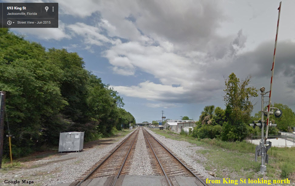
KING STREET / ROSSELLE STREET -- Back to back crossings.
This section of the former Coast Line probably looks more like the old school double track Atlantic Coast Line main then anywhere else on the Westside. These crossings being near an intersection are almost in the same location and remains of the one-time many sidings are easy to spot. The best thing this stop has going for it is 'Bold City Brewing' with a craft beer brewery and pub on King Street next to the railroad with good parking. Lodging is better found elsewhere. Safety on this end of King is still spotty and we might label it a 3-4.
 Rosselle St next crossing north
Location CL-3
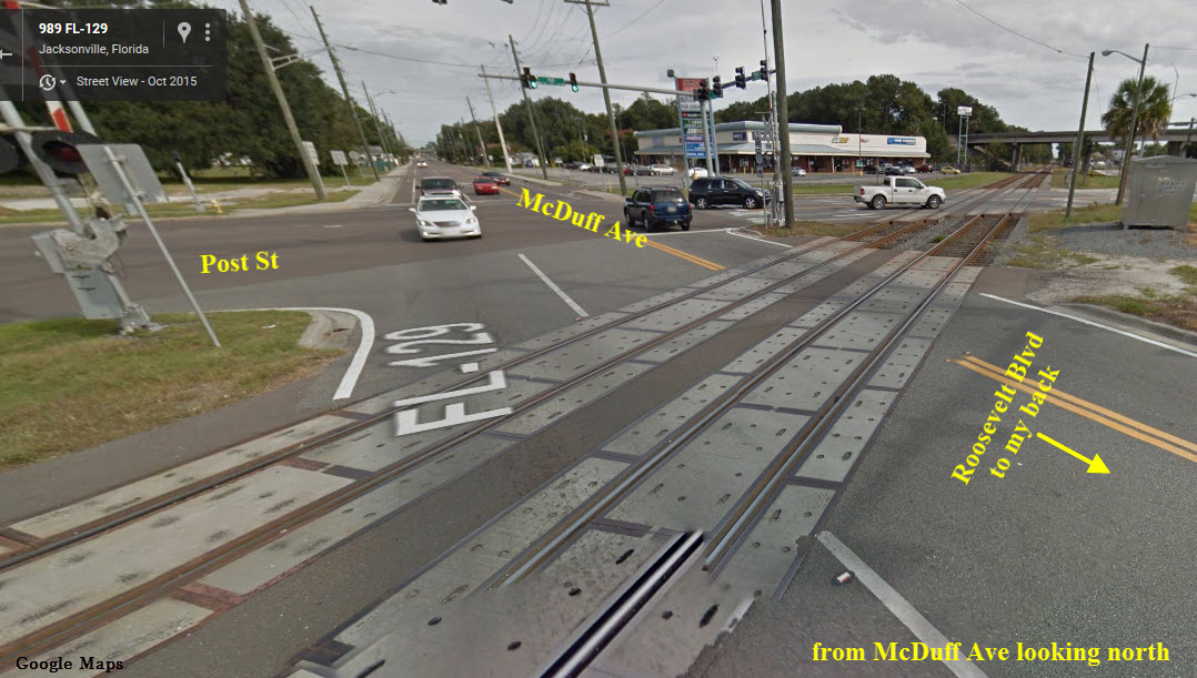
MC DUFF AVENUE (FL-129)/ POST STREET
Moving out of the inner city and into the urban streetcar suburbs the north end of Roosevelt Blvd is generally pretty sleepy but it affords lots of angles for some urban/suburban rail photography. The old Traction Company streetcar line crossed the railroad where College Street lines up with the track more or less under the overpass. The streetcars traveled down the west side of the ACL to a turning loop at Edgewood Avenue, that broad green space between Plymouth Street and the CSX mainline is easy to see, follow or photograph today. McDuff and Post Street are angled crossings with a major intersection sitting nearly under a freeway spur, when a train comes along the whole area lights up like Christmas, railfan or signal buff heaven. Lodging is still no closer than Downtown or just south in Orange Park. Food can be found in the first two blocks of Edgewood just west of Roosevelt, or at the aforesaid Park and King Street location. Safety improves as one travels south and a 4-5 rating is reasonable.
Location CL-4
EDGEWOOD AVENUE
This crossing marks the business district of the historic streetcar suburb City of Murray Hill Heights. Long since annexed by Jacksonville and known today simply as Murray Hill, it is among the newest of a steady parade of thus far successful neighborhood preservation and revival efforts. The crossing was once the site of a tiny Atlantic Coast Line way station. The Traction company reached this business district via the link between Plymouth Street and the current CSX mainline, the broad center median featuring ample parking was once the double track streetcar stop. Dining in Murray Hill can be fun for foodies as more and more mom and pop specialty outlets open along the avenue, even the Billionaire owner of the NFL Jacksonville Jaguars is in on the act. Edgewood is a good drive if one wants to make the cut-off between the historic Westside and the old Seaboard Air Line Railroad / CSXT 'S' Line or the Northwest side of town including Amtrak and the railroad various railroad yards. To the point of safety on Edgewood in the old Murray Hill shopping village it could be rated a '5' however, moving northwest on the Avenue that rating drops as precipitously as it raises going toward the St. Johns River.
Location CL-5
PLYMOUTH STREET
Still in Murray Hill, across from the Florida State College at Jacksonville is a curve that is one of two popular with the early Atlantic Coast Line advertising executives. The downside is there isn't much in the way of parking and if one parks on the College property you are forced into a dangerous game of Frogger dodging the insanely fast traffic on US-17. Nothing to eat and no where to sleep and though the curve was once popular, it wasn't the most popular photo spot. Considering the traffic I would rate this crossing a 4-5, be careful.
Location CL-6
SAN JUAN AVENUE
The buffer between Murray Hill and Lake Shore (the first automobile centered development in the city) there are plenty of places to find parking in this area. Just to the north the little 'Fishweir Creek Valley' is crossed on a fill with a bridge over Park Street. St. Johns Avenue was marked by another Atlantic Coast Line way station in years long past, even so, every train to pass by reports its passing 'St. Johns Avenue.' Again I'd advise against challenging Roosevelt Blvd (US-17) or San Juan Avenue on foot. A short move of location and there are plenty of places to eat along San Juan, Roosevelt or in the nearby Roosevelt Plaza. Safety in this area, even allowing for traffic is a strong 5-6.
Location CL-7
LAKESHORE BLVD, This is 'COAST LINE PHOTO NIRVANA!'
If you can find your way to this crossing, you are at the famed publicity photo site for the Atlantic Coast Line, Seaboard Coast Line, Family Lines and today's CSXT. The new bridge and wider highway do limit the angles a bit more than the historic setting, but it's still great for killer good photos. It's easily accessed using Roosevelt (US-17) to Wabash Avenue east to a right turn onto Lakeside Drive which becomes Lakeshore Blvd at the tracks. Parking along the side of the road or at any one of the Marina's is pretty easy. Looking down the track south of the crossing one can see the shift where the old ACL double track was pulled up and replaced with todays singe track mainline. There are also photo opportunities along the remaining portion of the old highway bridge which was retained as a fishing pier and just happens to run right alongside the mainline. Food is easily available at the Roosevelt Plaza or just south at 120th Street in Yukon and Lodging is just south in Orange Park or for military veterans at the Navy Lodge at Air Depot Jax. Those same veterans will find some excellent eating establishments on the base as well as a food court at the Navy Exchange Complex. Safety in this area is easily a 7-8.
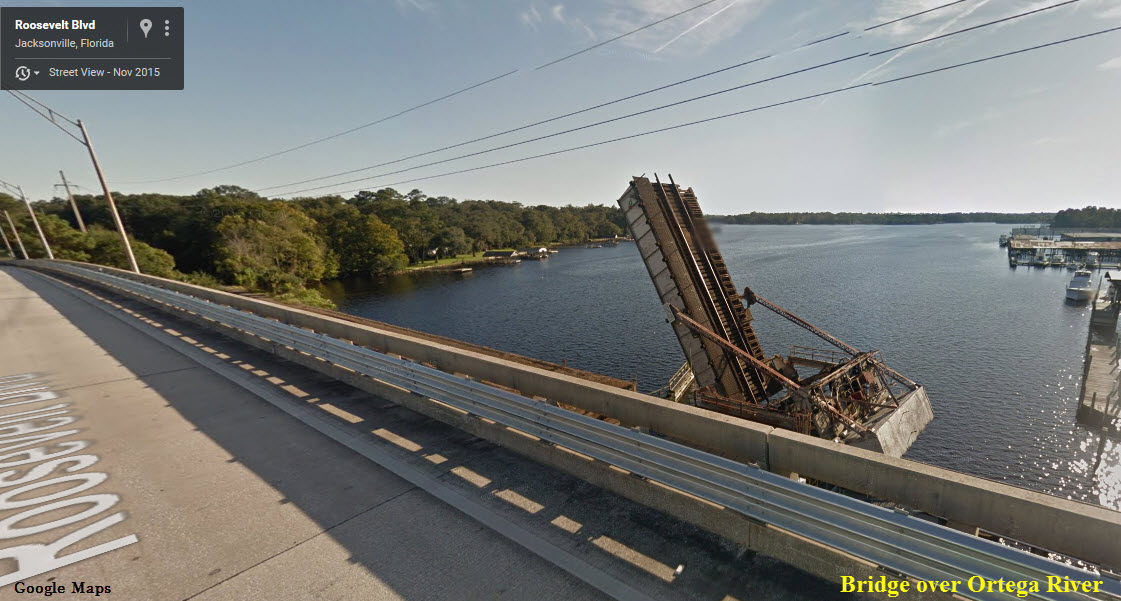
Bridge over the Ortega River
Picture is a screenshot from Google Maps. Good pictures can probably be had from one of the docks. T.
CSXT / FORMER ATLANTIC COAST LINE 'A' LINE SOUTH
 Take me to:
CL-8 CL-9
CL-10 CL-11
Take me to:
CL-8 CL-9
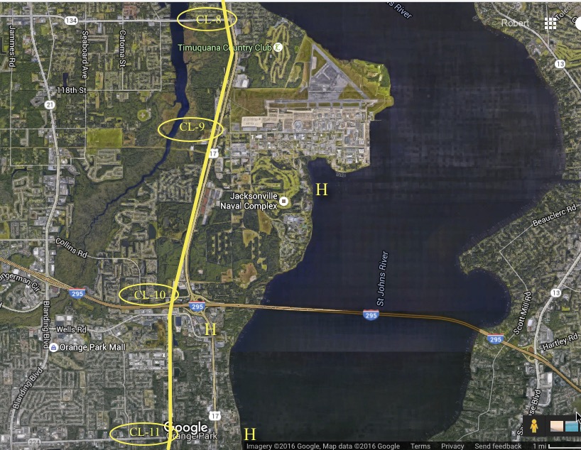
CL-10 CL-11Location CL-8
TIMUQUANA ROAD / VENETIA VILLAGE
From Roosevelt Blvd (US-17) it is possible to cross the tracks and park alongside Water Oak Lane. Respect the tracks as this is some fast and getting faster territory for Amtrak Trains to and from Central/South Florida. The only thing that sets this area apart from other stop locations is ease of parking and the fact that you can approach near enough to the track without being in somebody's yard, or in the path of some crazed driver. This is pretty classic ACL/SCL and was double track all the way from Richmond VA until the early 1960's. Food is easily available at the Roosevelt Plaza and Lodging is just south in Orange Park or for military veterans at the Navy Lodge at Air Depot Jax. Those same veterans will find some excellent eating establishments on the base as well as a food court at the Navy Exchange Complex. Safety in this area is easily a 7-8.
Location CL-9
"YUKON ROOD"
was the iconic answer to countless calls to and from the Jacksonville dispatcher. Pete Rood was something of a neighborhood fixture and the Yukon way station stayed busy through the 1960's long outliving many of it's counterparts. One reason being; if you are driving south in the far west side or slow lane of US-17 from 120th Street all the way to Ortega Hills Boulevard you are driving down the right-of-way of the former US Navy shortline railroad. Jacksonville being the location of pilot training during WWII, a myriad of aviation schools and as the Navy's number one overhaul and repair center there are massive warehouses and weapons storage on the south end of the base, these were a maze of track as aviation parts and weapons arrived or departed by rail. From the warehouse area the Navy Railroad crossed Roosevelt or US-17 across from Ortega Hills Boulevard intersection. From that point they ran outside of the base fencing up the side of US-17 including up the east side of the Yukon Station. Leaving the station after exchanging freight waybills 'The Navy Train' as it was locally known would swing back across Roosevelt and between the new hangers and the runways all the way to the waterfront where the actual maintenance work is/was performed. A connection came out of the base north of 120th Street where the current truck gate is but that was later changed to a new interchange at the Ortega Hills Boulevard end, the interchange track is still in place. Historically Yukon was also the end of the long double track mainline from Richmond. ACL/SCL often parked long lines of camp cars at Yukon and passenger trains still called occasionally until the dawn of Amtrak. The Naval base in it's prior incarnation as the Army's Camp Johnston was the end of what is probably the longest electric streetcar line to ever operate in Florida, starting in 1918 cars operated in non-stop express service between the waterfront on the base and downtown Jacksonville. Between the depot and 120th Street was a team track area that was nearly always full of equipment loading or unloading wood, gravel and other products. Railway Express trucks were also regulars at this busy station and it's freight platform was usually crowded with cargo, particularly outboard motors. Today little remains, the depot stood north of the crossing at Norman Street, entrance to Tilly Fowler Park. The Park occupies what was once the Navy housing area known as Dewey Park. 120th Street itself is the main street of Jacksonville's 'Ghost Town' known as Yukon. Prior to that this ground was the scene of the US Army's Camp Johnston and Camp Foster. It's fun to explore the abandoned roads and sidewalks of the old village. Amtrak action is very fast and quite impressive here and there are other spots along through the park where good photos can be gotten. Food is HIGHLY recommended at TRENT'S SEAFOOD at the end of 120Th Street in Yukon. Lodging is easy to find in Orange Park on Roosevelt (US-17) at I-295 and on the Navy Base if one is so entitled. Safety in this area is easily a 9-10 (Though you might think differently if you run across the Yellow Jackets I found napping under one of those old sidewalks)!
Location CL-10
COLLINS ROAD -- Orange Park/Jacksonville at the County Line.
Once again, you are along some high speed track so beware. There are several good parking places just west of the tracks. About 1/4 of a mile north is a long passing siding frequently used to hold out trains for opposing meets. There are also two cement plants either of which can be the seen of occasional switching action. Food is HIGHLY recommended at 4-Rivers BBQ near the corner of Well's Road and US-17 or at TRENT'S SEAFOOD at the end of 120Th Street in Yukon. Lodging is easy to find in Orange Park on Roosevelt (US-17) at I-295 and on the Navy Base if one is so entitled. Safety in this area is easily a 9-10 .
Location CL-11
KINGSLEY AVENUE in Orange Park
at the CSX tracks is the site of the old Orange Park, Atlantic Coast Line Station in this bustling Clay County hot spot. The Orange Park station yielded to the Yukon depot in the 1950's and until the mid 1960's, Orange Park was nothing more than a side track, a yellow flashing light (specifically at Kingsley and US-17) Setzers Market and not a whole heck of a lot more. Today the Orange Park area counts some 1/4 million people within a stones throw of that old flashing light. Today an establishment called 'Orange Park Station' is located on the north side of Kingsley at the railroad tracks is a Private Railroad Car facility. 'The Georgia,' the car used by President Obama on this campaign can usually be found there along with it's sisters sleeping under the giant oak trees. Kingsley Avenue itself is a traffic nightmare and the smaller roads that twist and snake along the railroad to the south skirting Doctors Lake, while offering a few photo locations are also the scene of constant car -v- train news stories. Lodging is easy to find in the area as is food, generally all of the Orange Park area hovers around the 6-10 safety rating but the Kingsley crossing and Private Car lot are a 9-10 except for automobile operators high on exhaust fumes.
HOTELS AND LODGING
For lodging in the CL / Coast Line Westside, I personally recommend:
CL-1 - CL-5:
RIVERDALE INN B&B - 1521 Riverside Avenue, Jacksonville FL 32204
Phone: 352-414-1020
CL-8 - CL-10:
NAVY LODGE (Military or Veterans only) - 6099 Mustin Road, Jacksonville FL 32212
Phone: 904-772-6000
CL-10:
CLUB CONTINENTAL (Bathe yourself in the real Florida) - 2143 Astor Street, Orange Park FL 32073
Phone: 844-296-1277
CL-11:
HOLIDAY INN HOTEL AND SUITES - 620 Wells Road, Orange Park FL 32073
Phone: 904-562-7400
Other Attractions in the 'CL' area:
Cummer Art Museum
Tilly Fowler Park
CL' Area Shopping:
5-Points
Park and King
Avondale
Roosevelt Plaza
NAS Jax
Orange Park Mall
Local CSX Railroad Police Warning
Railfan’s will find the CSX is quite actively unfriendly with railroad police constantly patrolling or following trains on each of the lines in and out of the City limits. My own experience as a retired railroad consultant and historian was quite funny but could have been sad if not downright stupid. I had just shot the southbound Silver Meteor at the crossing across from NAS Jax and walked up to the crossing as she passed to grab that tail end shot. Turned around and a 10’ foot tall railroad cop was standing behind me, blue lights flashing on his vehicle. “What do you think you’re doing? he said. Overcoming the urge to give him a smart ass answer I told him: “Just taking photos.” “This is private property, “Let me see your license," was his stoic reply, then he added: “How do you know you won’t get hit by another train?” “Um? Because this is single track and the train just passed?” “No! Another train! How do you know you won’t get hit by a following train?” "Well that (nearby) signal tells me there is no other train…” Then out comes the attitude; “Oh the signal told you eh? I think I know a hell of a lot more about railroads then you’ll ever know and your name is being entered in our database…” etc. So this is how I became a hardened criminal standing at a public crossing on the Southwest side of Jacksonville, gee thanks CSX, you’ve just made another friend.
CSX Honeymoon Yard
While the average Jaxson may not be familiar with an area of Jacksonville's urban core being known as "Honeymoon," most railfans will. From the crest of the Beaver Street viaduct, many have made the voyage to see one of Florida's most important railroad junctions in action. Nearly a mile in length, the Honeymoon Yard and Wye is where the CSX Transportation (CSX), Florida East Coast (FEC), and Norfolk Southern (NS) railroads converge. However, the name Honeymoon predates this important junction.
Honeymoon was the name of Colonel Lucius Augustus Hardee's home two miles west of Jacksonville's Union Terminal. It was built within close proximity of the Florida, Atlantic and Gulf Central Railroad, which opened in 1860, linking Jacksonville and Alligator Town (Lake City). Prior to the Civil War, by 1860, Hardee was one of the largest planters and slaveholders in Florida owning long staple cotton plantations in Hamilton County, FL and the 748-acre Rural Home Plantation. A soldier in the 3rd Seminole War, Hardee was the also the first Commissioned Officer from Florida in the Civil War, serving as the Captain of a group of soldiers known as Duval's Cowboys.
Hardee's Rural Home operation was destroyed during the Civil War. Employing many of his ex-slaves, Hardee built the lavishly landscaped Honeymoon residence to replace the Rural Home. Hardee and his wife, Esther C. Haddock, selected the name in honor of her brother, William Haddock, and his new wife who were the first guest at the new residence. Here, Hardee entertained several guests, including Harriet Beecher Stowe, a noted 19th century author and seasonal resident of Mandarin. Hardee also established a citrus nursery at Honeymoon, providing trees for many new orange groves in the area.
Known as a "Renaissance Man of his Time and Place," Hardee also once believed he could cure Yellow Fever. He developed a theory that the germs of the fever floated in the air, an assumption which has since been proved by the discovery that mosquitoes transmit the disease. He believed the germs could be killed by concussion.
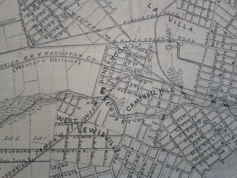
Map of Jacksonville, showing the location of Honeymoon and Campbell Hill in 1887.
Despite Hardee's triumphs and failures, rural life west of LaVilla and downtown Jacksonville was quickly coming to an end. By 1880, Jacksonville had replaced Pensacola as Florida's largest city. Five years later, Colonel Lucius Augustus Hardee died of malaria at the age of 56. The next year, his Honeymoon residence burned to the ground. The next year, in 1887, Honeymoon was annexed by the City of Jacksonville, along with neighboring LaVilla, Brooklyn, Riverside, Springfield, Durkeeville, East Jacksonville, Fairfield and Oakland. By this time, Honeymoon had platted streets named after fruits such as Lemon, Grape, Pineapple, Orange, Peach and Plum.
For more info on the plight of the urban core, click here.
Courtesy of the University of Texas Library, here for their index page. Large map. Few bridges back then, and of them, most of them were railroad bridges.
Disclaimers:
I love trains, and I love signals. I am not an expert. My webpages reflect what I find on the topic of the page. This is something I have fun with while trying to help others. My webpages are an attempt at putting everything I can find of the subject in one convenient place. There are plenty of other good websites to help me in this effort, and they are listed in the links section on my indexa page, or as needed on individual pages. Please do not write to me about something that may be incorrect, and then hound the heck out of me if I do not respond to you in the manner you would like. I operate on the "Golden Rule Principle", and if you are not familiar with it, please acquaint yourself with how to treat people by reading Mathew 7:12 (among others, the principle exists in almost every religion). If you contact me (like some do, hi Paul) and try to make it a "non-fun" thing and start with the name calling, your name will go into my spambox list! :-)
Please Note: Since the main focus of my two websites is railroad signals, the railfan guides are oriented towards the signal fan being able to locate them. For those of you into the modeling aspect of our hobby, my indexa page has a list of almost everything railroad oriented I can think of to provide you with at least a few pictures to help you detail your pike.
If this is a railfan page, every effort has been made to make sure that the information contained on this map and in this railfan guide is correct. Once in a while, an error may creep in, especially if restaurants or gas stations open, close, or change names. Most of my maps are a result of personal observation after visiting these locations. I have always felt that a picture is worth a thousand words", and I feel annotated maps such as the ones I work up do the same justice for the railfan over a simple text description of the area. Since the main focus of my website is railroad signals, the railfan guides are oriented towards the signal fan being able to locate them. Since most of us railheads don't have just trains as a hobby, I have also tried to point out where other interesting sites of the area are.... things like fire stations, neat bridges, or other significant historical or geographical feature. While some may feel they shouldn't be included, these other things tend to make MY trips a lot more interesting.... stuff like where the C&O Canal has a bridge going over a river (the Monocacy Aqueduct) between Point of Rocks and Gaithersburg MD, it's way cool to realize this bridge to support a water "road" over a river was built in the 1830's!!!
My philosophy: Pictures and maps are worth a
thousand words, especially for railfanning. Text descriptions only
get you so far, especially if you get lost or disoriented. Take
along good maps.... a GPS is OK to get somewhere, but maps are still
better if you get lost! I belong to AAA, which allows you to get
local maps for free when you visit the local branches. ADC puts
out a nice series of county maps for the Washington DC area, but their
state maps do not have the railroads on them. If you can find em,
I like the National Geographic map book of the U.S..... good, clear, and
concise graphics, and they do a really good job of showing you where
tourist type attractions are, although they too lack the railroads.
Other notes about specific areas will show up on that page if known.
Aerial shots were taken from
www.bing.com/maps. The screen
captures
from Bing are made with Snagit, a
Techsmith product... a great
tool if you have never used it!
Beware: If used as a source, ANYTHING from Wikipedia must be treated as being possibly being inaccurate, wrong, or not true.
RAILFAN GUIDES HOME
RAILROAD SIGNALS HOME
NEW
1FEB2016
Last Modified
13-Feb-2016