In General
Getting Here
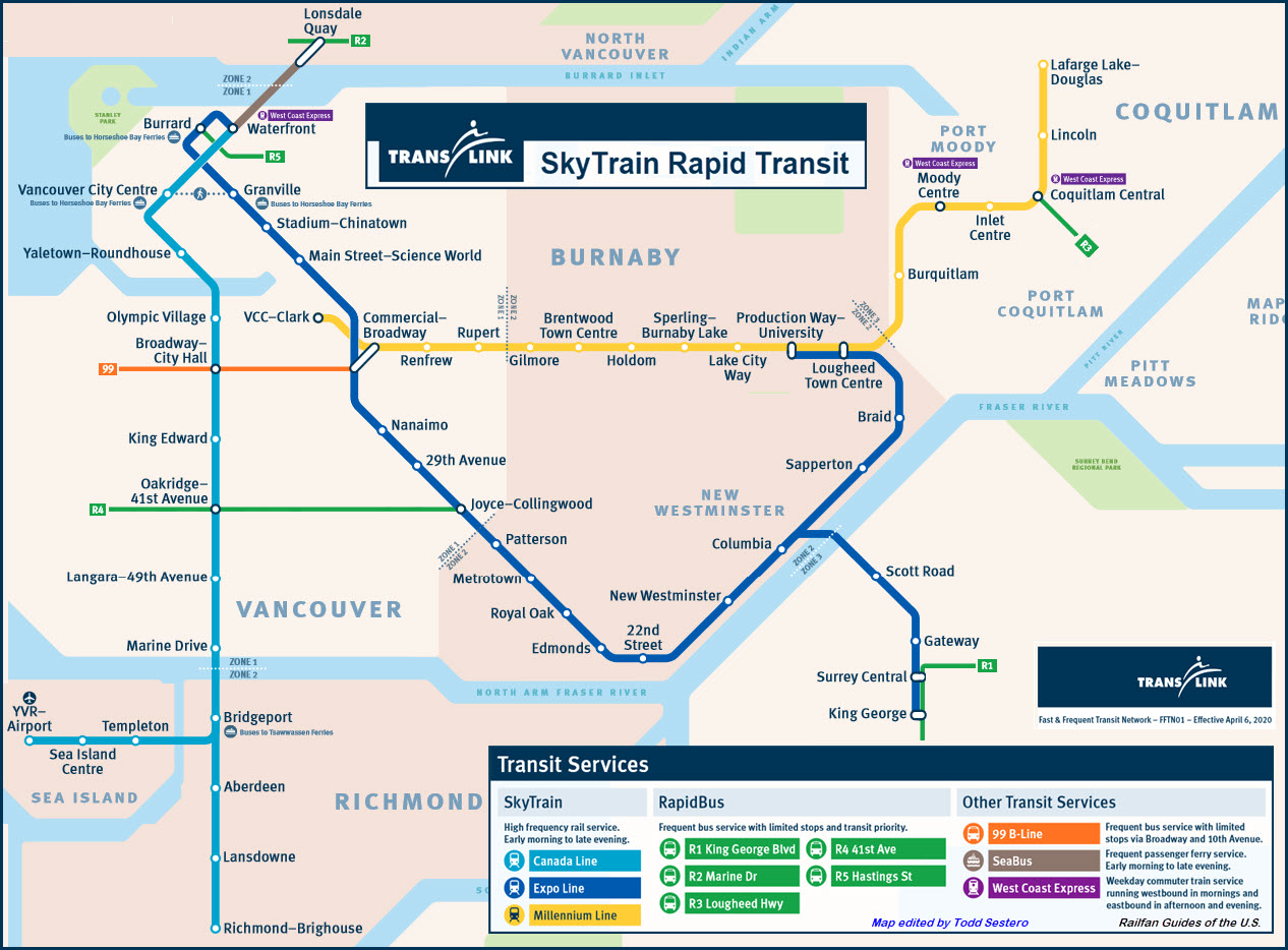
Map
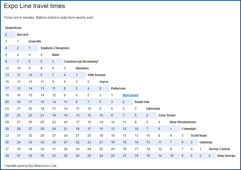
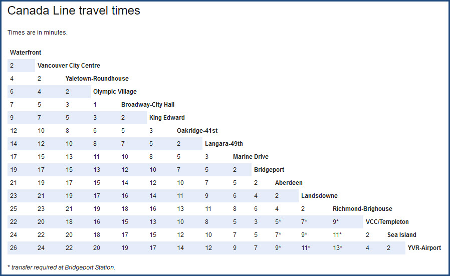
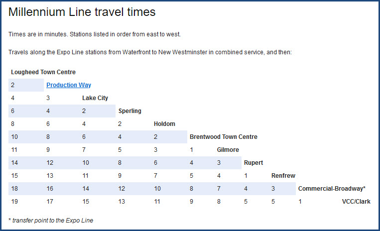
Travel Times
Pictures
Floobydust
RAILROAD SIGNALS HOME
Location / Name:
Vancouver BC
What's Here:
Skytrain Rapid Transit System
West Coast Express (Regional Commuter Rail)
Via
Amtrak
Data:
GPS Coordinates: as needed
Phone A/C: 604
ZIP: V6A 4C7 (at the Pacific Central Station)
Access by train/transit:
see above
The Scoop:
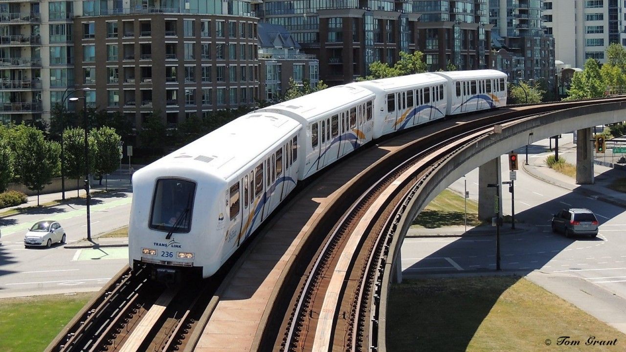
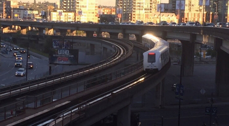
SkyTrain is the oldest and longest, fully-automated, driverless, rapid-transit system in the world. It is powered by a third rail.
There are three integrated lines:
-- The Expo Line connects Vancouver with the cities of Burnaby, New Westminster, and Surrey.
-- The Millennium Line travels from Vancouver through Burnaby into Port Moody and Coquitlam.
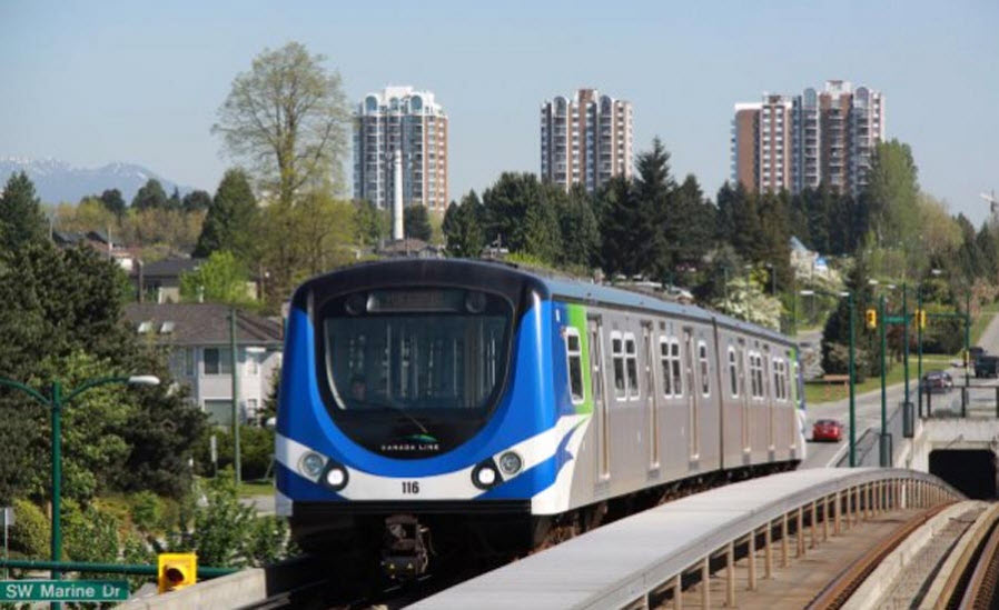
-- The Canada Line connects downtown Vancouver to the Vancouver International Airport (YVR), and the City of Richmond.
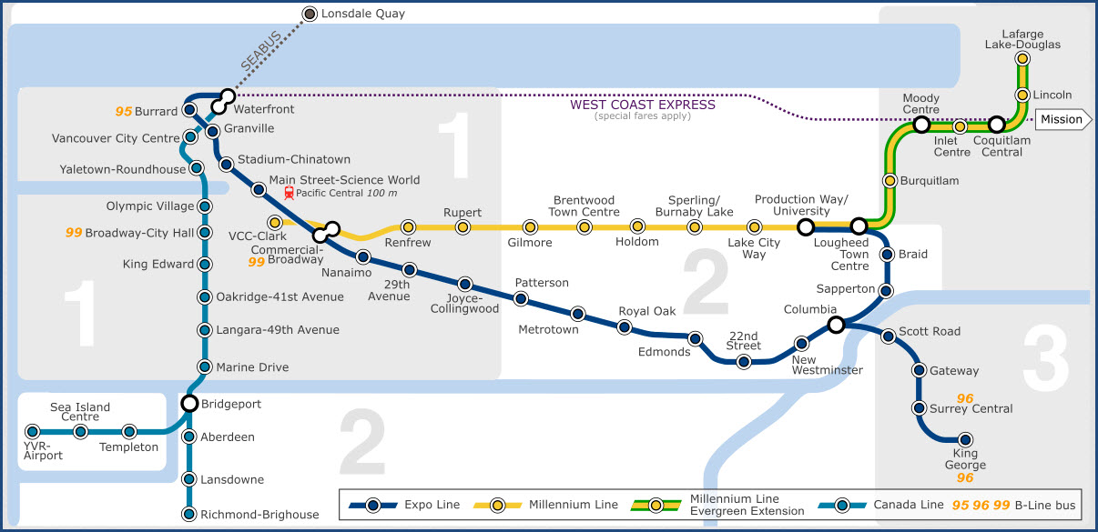
The Expo Line
The Expo Line is the oldest line of the SkyTrain rapid transit system in the Metro Vancouver region of British Columbia, Canada. The line is owned and operated by BC Rapid Transit Company, a subsidiary of TransLink, and links the cities of Vancouver, Burnaby, New Westminster and Surrey.
The line was originally known only as "the SkyTrain" from its inception in 1985 until 2002, as it was the system's only line during this time. In 2002, after the opening of the system's second line, the Millennium Line, the original line was given the name "Expo Line". The new name was in recognition of Expo 86 (the World's Fair that Vancouver hosted in 1986) as the transit system had been built in large part as a showcase and an attraction for that fair.
What is now known as SkyTrain began as a demonstration project to showcase the newly developed linear induction propulsion technology to Vancouver and other prospective cities throughout the world. Although Toronto's Scarborough RT was completed before the Expo Line in 1985, the ICTS demonstration was the first system to use SkyTrain technology. The Intermediate Capacity Transit System (ICTS) demonstration was built using the Advanced Rapid Transit (ART) technology developed by the Urban Transportation Development Corporation (now part of Bombardier). Construction began on March 1, 1982 and was completed in early 1983. The demonstration project consisted of just one station and about one kilometre of guideway with no switches. This original station was not "named" during this time as it was the only station, but then in 1985 opened as Main Street station.
Ridership on the Expo Line is continually increasing, and plans are being developed for upgrading capacity to meet future ridership levels. Several options are being considered and/or planned, including: Purchasing middle "C" cars to use with some of the Mark II/III trainsets to maximize available platform space. Current platforms can fit six-car Mark I trains and five-car Mark II/III trains. Six-car Mark I trains are more increasingly being used, but TransLink can only create two- and four-car Mark II trains with its fleet (2 or 2+2). By adding a middle "C" car to some Mark II/III couplets to create three-car trainsets, longer five-car trains can be used (2+3). As of December 2016, only the Mark-III vehicles employ the use of the middle "C" car, creating a four-car train.
Operating headway between trains during peak times is maintained at 108 seconds. SkyTrain can run at 75 second headways, which will allow for more trains to operate at peak times.
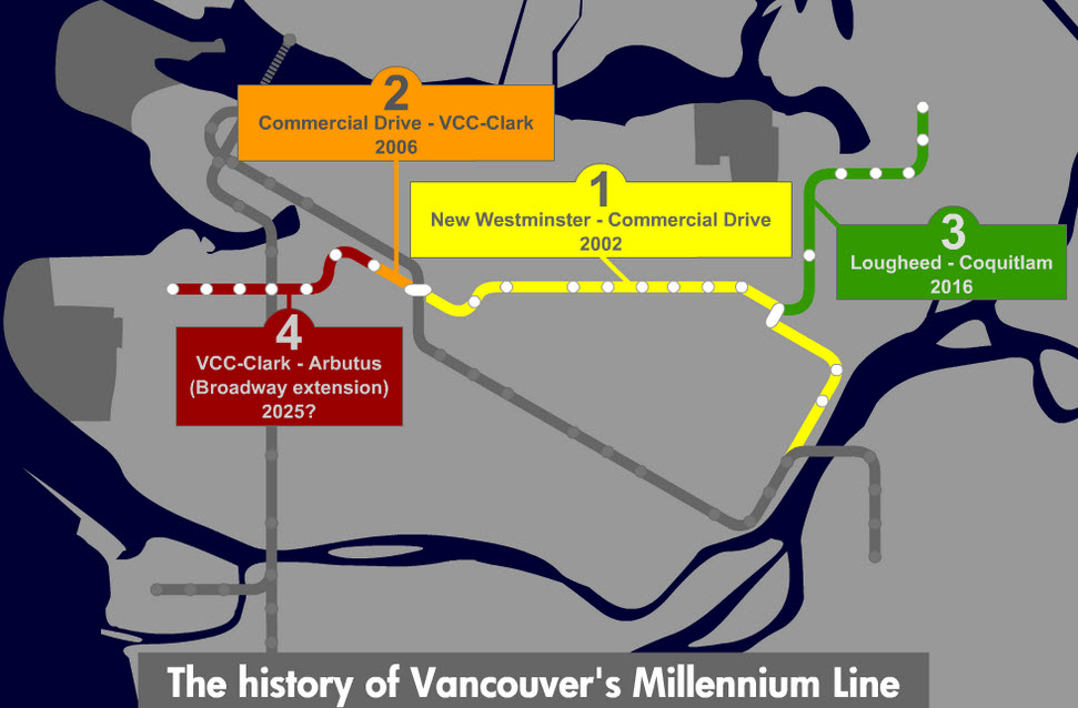
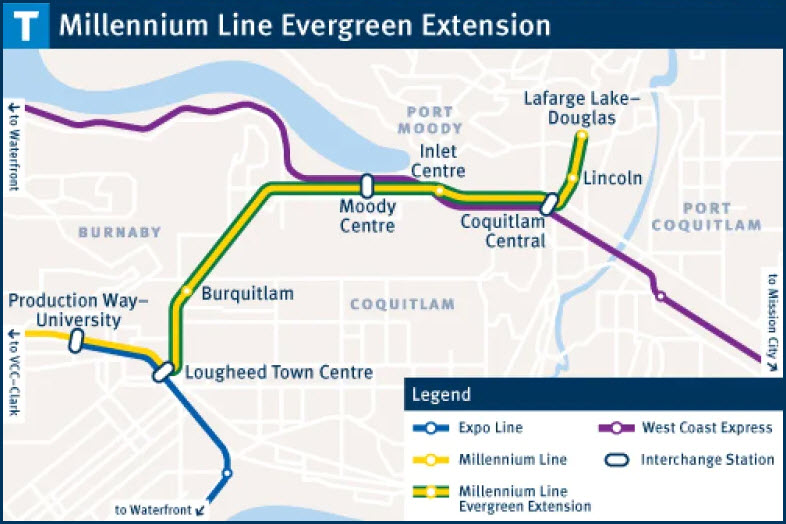
The Millennium Line
The Millennium Line connects VCC–Clark with Lafarge Lake–Douglas. The line travels along an elevated guideway for most its route with portions tunneled and at-grade. The line is 31.2 km (19.4 mi) long with 17 stations, and the line opened on January 2nd, 2002. Service runs seven days a week.
The line opened in several phases. Phase I of the Millennium Line was to be from Waterfront to Braid, which is the section that opened on January 2, 2002. Phase II, from Braid to Commercial Drive, opened on August 31, 2002. Initially, Phase II was to also include the PMC Line (Port Moody- Coquitlam Line) and service was to be from Braid to around Granville Street and 10th Avenue in Vancouver. In preparation, a third platform was constructed at Lougheed Town Centre. Following a change of government from BCNDP to BC Liberals during construction, the PMC Line was scrapped and Phase II shortened to Braid to Granville and 10th. However, due to problems with land negotiations for the construction of VCC–Clark Station, Phase II was shortened again to Commercial Drive. It wasn't until 2006 that VCC–Clark opened, but the original Phase II plan of continuing deeper into Vancouver was subsequently scrapped due to a decreased priority.
In 2003, the Lake City Way station opened after construction delays.
On October 22, 2016, the section between Waterfront and Braid was changed to the Expo Line and the Millennium Line was shortened to run between VCC–Clark and Lougheed Town Centre. On December 2, 2016, the Evergreen Extension opened, extending the Millennium Line to Lafarge Lake–Douglas.
An extension is underway, and will include an additional 5 stations. The Broadway Extension will be elevated from VCC–Clark along Great Northern Way, where it will go underground and continue along Broadway.
The Canada Line
Coloured turquoise on route maps, it operates as an airport rail link between Vancouver, Richmond, and Vancouver International Airport. The line comprises 16 stations and 19.2 kilometres (11.9 mi) of track; the main line runs from Vancouver to Richmond while a 4-kilometre (2.5 mi) spur line from Bridgeport station connects to the airport. It opened on August 17, 2009, ahead of the 2010 Winter Olympics. Each Canada Line station is slightly different in appearance, designed to blend in with the surrounding neighbourhood.
The Canada Line operates on a "Fare Paid Zone" system. Passengers are required by law to possess a valid fare when they are in Fare Paid Zones. Fare Paid Zones are clearly marked, and fares can be bought from Compass Vending Machines at all stations. Fare inspections are mostly conducted by the South Coast British Columbia Transportation Authority Police Service. Passengers who fail to pay the fare or do not have a valid fare may be fined $173 and/or removed from the station or train.
Canada Line attendants are the customer service staff for the Canada Line. They are easily identifiable by their green uniforms. They provide customer service, troubleshoot certain problems with the trains, observe and report safety issues, and check fares.
Corporate Overview:
Officially recognized as the South Coast British Columbia Transportation Authority, most simply know us as TransLink. Created in 1999, we deliver our services through contractors as well as our operating companies and subsidiaries like Coast Mountain Bus Company, British Columbia Rapid Transit Company Ltd. (SkyTrain) and West Coast Express Ltd.
Together with our partners, stakeholders and operating companies, TransLink plans and manages the region’s transportation system as a strategic whole. We are dedicated to creating and sustaining a transportation system that meets the needs of residents, businesses and goods movers in a manner that protects the environment and supports the economic and social objectives of the region.
Acknowledgements:
Tom Grant
Denver Todd
Wikipedia
Google Maps
Bing Maps
Websites and other additional information sources of interest for the area:
https://cptdb.ca/wiki/index.php/SkyTrain_Millennium_Line
https://en.wikipedia.org/wiki/Expo_Line_(SkyTrain)
https://cptdb.ca/wiki/index.php/SkyTrain_Expo_Line
https://www.enr.com/blogs/15-evergreen/post/48624-vancouvers-skytrain-takes-next-step-toward-new-extension
https://en.wikipedia.org/wiki/Canada_Line
https://cptdb.ca/wiki/index.php/SkyTrain_Canada_Line
https://bcpassport.com/public-transportation/vancouver-skytrain/
I-5 turns into Highway 99 at the border, and takes you into the downtown area. After that, you're on your own.
Trans Canada highway 1 brings you in from the east. Making a left at Hastings / 7A... looks like it will bring you into the downtown area.
Use your GPS to supplement for specific locations, there are just too many.
None for now......
Disclaimers:
New format 10/26/23: Please check out my disclaimer page for my standard dribble and contact info here
RAILFAN GUIDES HOME
RAILROAD SIGNALS HOME
NEW SEP26/2020, OCT01/2020, MAY15/2026
Last Modified 16-May-2026